Democratic Planning in the Age of Urban Freeways and Today

I finished reading two very different, but equally interesting and informative, recent urbanist-y books over Shabbat. The first is Akum Norder’s The History of Here, a fun and talented Albany writer’s look into the history of her family’s house, the people who have inhabited it, and the life of the neighborhood around it. The second is Karilyn Crockett’s People Before Highways, an ethnographic and historical look of the anti-freeway movement in the Boston area in the 1960s and ‘70s. Both books are worthy of a full-scale review that I may or may not be able to undertake at some point, but I wanted to pull out a common element that I think makes for an interesting, and very relevant, point of discussion: the question of how democratic planning should be, and how that should look.

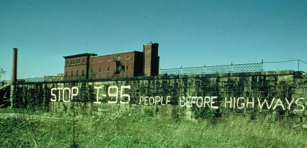
Let’s start with People Before Highways. Crockett’s work is essentially an ode to the grassroots anti-highway backlash that transformed transportation policy in Massachusetts and led to the end of freeway building inside the Route 128 beltway and the ability to “flex” federal transportation spending from highways to transit. Boston’s anti-freeway coalition was a broad–and varying at different times–group of institutions, scholars, “radical” planners like future Massachusetts Secretary of Transportation Fred Salvucci, and community members. The last element is perhaps the most interesting; participants ranged from tenant activists in public housing to Black Panthers to patricians in Brookline and Cambridge to people we would now identify as first-wave gentrifiers in the South End and my own neighborhood of Jamaica Plain. This coalition demanded not just an end to highway building, but also to the heavy-handed way in which the freeways had been planned, and significant amounts of land taken, with virtually no opportunity for public input. Crockett wastes no opportunity to remind the reader that the demands of the Boston anti-highway movement were not just specifically anti-highway, but processually radical and progressive in their insistence on the distribution of power.

Certainly, the righteousness of the Boston anti-highway, pro-public participation cause is not in dispute; it’s a difficult book to read for a professional planner. One thing that strikes me about Crockett’s work, though–and it’s a problem I’ve seen elsewhere in leftist planning thinking and writing–is that her narrative is shaped by a powerful nostalgia for the kind of grassroots planning and localist democracy that her subjects believed in, but doesn’t engage with some of the potential challenges of a highly democratic process. Indeed, some of the potential challenges with such a process show up even within her own research. In the sixth chapter of the book, Crockett profiles the planning process around the creation of the Southwest Corridor linear park, by all accounts pretty much a triumph of democratic planning that created a valuable community amenity and showpiece to this day. The cracks in the process of democratic planning, though, show through this account. Crockett shows how the South End community was able to demand that the Southwest Corridor trench through their area be roofed over to reduce noise, pollution, and vibration. This is, of course, not an unreasonable ask–but Crockett’s account makes it clear that the presence of educated, middle class people in the neighborhood, including some who we would clearly call gentrifiers today, was what got the deck built in that section, but not elsewhere in the Southwest Corridor. Why, one thinks today, is the trench not decked through Roxbury and Jamaica Plain? I lived a block from the trench for my first 10 months in Boston, and one can feel the vibrations and hear the roar from passing trains. A purely “democratic” planning process is already one that gives greater voice to those able to shout loudest–and Crockett’s account of the decking of the South End trench shows how this can lead to opportunities being available inequitably.

Crockett also narrates the process for planning the park that went on top of the South End trench, and if anything it reveals more of the cracks in the facade of democratic-planning-as-magical-cure. She writes:

By removing the railroad’s stone embankment and inserting decking along segments of each section of the Corridor, the Southwest Corridor planners knit together neighborhoods that had been physically separated for more than a century. Not every resident viewed this as social progress…The existing railroad right-of-way created a dividing line between the South End and St. Botolph neighborhoods. Though these two areas held only slightly different economic profiles, their racial and ethnic compositions could not have been more different. St. Botolph residents constituted a largely homogeneous block of white families and some professionals working in the city. Though they themselves were city dwellers, many St. Botolph residents looked askance at the idea that deck cover would allow other urban neighbors easy access to parts of their neighborhood previously blocked by the railroad. These residents used the Corridor’s public meetings to voice their opposition. (p. 187)

In other words, the residents of St. Botolph engaged in fairly standard-issue urban racism, classism, and (one would imagine, given the increasing gay population of the South End at the time) not a small amount of homophobia–and saw in the democratic Southwest Corridor planning process an opportunity to (very democratically!) write their oppressive agenda in concrete. Unfortunately, Crockett’s handling of this rather obvious challenge to the viability of democratic planning is less than inspiring. 

By listening and respecting the concerns of residents, [Southwest Corridor planners] were able to identify an architectural strategy that was responsive to the demands of St. Botolph’s residents but did not subvert the overall public planning agenda for the Corridor…[they developed] designs for a removable fence that could be unbolted at a later date should the neighborhood change its mind. Unfortunately, the design was compromised by another decision to lay granite at the base of the fencing, and when St. Botolph’s residents did, in fact, reverse their decision and requested direct access to the Corridor Park, it was no longer possible. (p. 188)

One must, I suppose, applaud the Corridor planners for their commitment to democracy, inasmuch as they were committed to listening to, to the point of acting to some extent on, an obviously bigoted agenda. To this day, many streets on the western side of the Southwest Corridor in this area dead-end at the Corridor Park with a wall or fence of some considerable height rising to prevent what should be an obvious pedestrian connection.

blackwood barrier

A democratically erected barrier preventing easy pedestrian access to the Southwest Corridor Park, Blackwood Street, Boston.

Crockett calls this “The seeming contradiction of a connective landscape needing to reconcile itself with existing race and class divisions and residents’ divergent opinions about what to do about them,” (p. 188) but–especially as one of the direct inheritors of the conflict around transportation planning in Boston–this feels like an unsatisfying resolution to me. Many of Crockett’s interviewees for the book talk about how they saw themselves as “advocacy planners,” adherents of a mid-’60s theory that planners should not be impartial experts, but advocates for the oppressed in society. It seems to me that there’s an obvious tension between this identification and engaging in a planning process that encodes racial and class injustice (literally building fences!) in the built environment in the name of “democracy.” While incredibly valuable for its documentation of the Boston anti-highway movement, and its repetition of the lesson that megalomaniacal centralized planning is generally abusive, People Before Highways would be more useful and convincing if it grappled honestly and openly with some of the shortcomings of the democratic, grassroots visions of planning that it advocates.

Akum Norder’s book, too, offers a lesson on this topic–and perhaps the juxtaposition of the two narratives can allow us to draw some conclusions about the intellectual and social milieu of participatory planning and its challenges. Norder’s book is an ode to her Pine Hills neighborhood, an absolutely lovely streetcar suburb-era area that reminds me strongly of the Westville section of New Haven where I grew up. Pine Hills originally and today is a strongly middle-class area with a strong communal identity; but it’s had its ups and downs, borders the “student ghetto,” and generally has some reasonable fear of tipping into neighborhood decline in the same way that most middle-class areas in cities that aren’t part of the overheated coastal housing markets do. As such (and seeing that many of the residents are educated, have money, or both), these neighborhoods are ripe for democratic, grassroots organizing around the issue of perceived problems–and using a democratic planning process to deal with them in a way that may work well for the neighborhood but not always for those pushed out as a result.

Norder profiles one such case (though without the slightly negative valence I’m attaching to it). She writes, on pages 204-205, of a property on the corner of North Allen and Lancaster that, at 5,921 square feet, held by the early 2000s twenty-six units. That is, of course, far more than current zoning would allow, but most of the neighborhood is nonconforming and grandfathered anyhow. Normally, such properties can continue unmolested unless the owner requests a change of use or makes major modifications; but city code allows for the property to be forced into conformance if it’s declared a nuisance property. And since the building in question does appear to have genuinely been a nuisance property, generating fights, noise, and an astonishing number of police calls, the local neighborhood association took the opportunity to force a zoning board hearing. They won, and the landlord had to empty the building to cut its units down to the allowed two.

So, on the one hand, this is a victory for a democratic planning process and for community concerns. The area residents took on a nuisance landlord, used the objective rule of law, and made their neighborhood a better place. Bully for them–we should encourage everyone to care about their neighborhoods like that. On the other hand, we’re talking about a process–a very democratic process–that led directly to the eviction of at least twenty-four people, with those who provoked it presumably taking no financial responsibility for their relocation. This being Albany, where rents are generally cheap, I think it’s reasonable to assume that few of those people were displaced from the area entirely; most were probably able to find housing relatively close, and quite possibly at not much increased rent. So the result isn’t necessarily the worst. But what if it weren’t Albany? What if this were a property in Boston, where rents are triple or quadruple what they are in Albany? Would we tolerate a neighborhood group getting together to democratically destroy what’s effectively an SRO, a vanishing resource for the very poor? How should a progressive advocacy planner react to this scenario?

I don’t have a coherent set of answers to these questions yet. But I think they’re crucially important to ask. And I think it’s important to recognize that the historical and socioeconomic context in which calls for grassroots, democratic planning came around has in many cases vanished. The type of democratic planning Kaitlyn Crockett profiles so well was a product of a city under siege, under threat of imminent literal physical destruction. Places like Albany may well still feel a lessened version of that threat. But in Boston, today, it’s gone. There is still a threat of displacement and destructive change, but it comes from the opposite end of the spectrum, from a hyperactive real estate market and the desire of many more people than the city has been willing to build housing for wanting to live here. Already in the time period that Crockett narrates privileged voices were figuring out how to use the democratic planning process to subvert planning aims of social justice and integration. We can’t, and we won’t, throw out the baby of democratic planning and extensive public outreach with the bathwater of urban renewal and highway building.  But we can, and must, recognize that there are tensions between promising all comers a democratic process and achieving egalitarian, democratic outcomes. Just this past week the Globe wrote about how Boston’s input-based sidewalk-repair system is failing poorer neighborhoods that are less likely to call in for repairs. Is it possible, one must ask, that planners again need to start putting our thumbs on the scales of justice–this time, to tip them back toward the right?

Featured image source: https://www.jphs.org/transportation/people-before-highways.html
Building Urbanism and Transit in Small Cities

I’ve been following updates from the APTA conference in the Twin Cities this past week via Twitter and a friend who works in the area. A couple of the tweets I saw really caught my eye and helped to crystallize some thoughts I’ve been having for a while, since thinking about the role of transit in smaller cities during my time in Albany.

The state of transit in the US is, generally, pretty damn poor, and this is especially true of smaller cities and towns. I’ve written a lot about cities in the size class of Albany, New Haven, or Providence, say in the 100,000-500,000 range, but I’m talking here about somewhat smaller cities, places like–to use near-Albany examples–Utica or Kingston. Generally, transit in those places is, shall we say, not particularly useful; generally it’s conceived of as a last resort, welfare transit, the kind of thing that only people with no other options use. That’s a product of mentality, but also of lack of resources.

But here’s the thing I’ve learned from exploring Upstate New York, much of New England, and a few choice parts of the Midwest: a lot of the older cities, even (in some cases especially) the smaller ones, really do have “good bones.” They are potentially salvageable as places of good, safe, walkable mixed-use urbanism. But there’s a catch–often, in my experience and observation, this is true only in one or two choice corridors. A city like Albany or New Haven might have several or numerous corridors appropriate for high-frequency transit and dense urbanism, but smaller towns may only have one. In both cases, the most urban corridor is likely underserved, because of the general terribleness of American transit; but in the smaller cities, this likely means that the city has lost any chance at transit-based urbanism at all.

In transit-planning terms, small-city transit leans quite heavily toward the coverage side of the coverage vs. ridership debate. That’s not a criticism, per se; it’s how the incentives–including funding incentives–are biased, as well as how local leadership generally directs transit agencies to operate. This is, of course, in direct conflict with the first point that Erik Landfried made in the tweets presented above–that the best practice in the transit world is to get your best corridors right first. So this post is, in part, a thought exercise about how small-city transit might look if more funding–or different funding–were available, enough to let agencies focus on intensive service on the best corridors.

It’s also a musing on the future of smaller cities. It’s not news that many of these places are struggling, facing economic marginalization and brain drain. In part–though only in part–those struggles derive from a lack of good urbanism; with terrible transit and general unwalkability, those who want or need an urban lifestyle often literally cannot find it in smaller cities. As Cap’n Transit has pointed out, these “small city exiles”–people who would have been able to stay if the good bones of smaller cities had better flesh built upon them–make up one of the gentrifying flows to larger cities. Note that this isn’t just a Creative Class follow-the-talent kind of a thing; it seems clear that smaller, fully car-dependent cities are simply inaccessible to many.

Whether Small City Exiles follow the jobs, or the jobs follow them, is of course a little bit of a chicken/egg problem, but it seems unlikely that many will return without the option of urbanism. The implication is that to have a shot at revival struggling smaller cities would do well to try to build at least one corridor where life can be conducted in a car-free (or, more realistically, car-lite) manner. Typically, discussions of urbanism, revival and/or gentrification occur at the neighborhood level, but one of the things that I think this typology of city can teach us is that the relevant unit may in fact be corridors. Not all efforts at revival have to be focused in one area; but there should be an emphasis on creating the ability to live urban daily life–with all of the uses that entails–along at least one given corridor in any city. That means frequent transit service; it means reviving or allowing mixed-use development; it means locating hospitals and schools and shops along that corridor to the extent possible. It’s the preservation, revival, or creation of these corridors that will make a small-city revival through urbanism possible. And it means that the identification and intentional development of these one or two possible transit/urbanist corridors is extremely important to the future of these cities.

What I’m aiming for here, then, is somewhere between descriptive and prescriptive; I don’t have specific infrastructural, financial, or operational ideas in mind, but I have, to illustrate, picked out a number of cities and corridors that I think fit this paradigm.

Utica’s a big enough city to have multiple viable transit corridors at some minimal frequency, but it has one that’s absolutely perfect for frequent transit and good urbanism. Genesee Street is Utica’s main commercial drag, is lined by fairly dense housing already, and is anchored on one end by Union Station–offering transfers to Amtrak and intercity buses–and on the other by a major mall. Current service is decent by small-city standards but the schedule is–typically of Centro, the operator–nearly incomprehensible.

Like Utica, the Binghamton area is big enough to support more than one transit corridor, but there’s one that really ties everything together. Stretching from Binghamton through the downtowns of the area’s several other decaying industrial cities, this corridor could, potentially, link a wide variety of different uses–although a strong system would need a link to Binghamton University too.

Kingston’s a relatively small place, but it still offers a strong corridor for building out an urban revival. Broadway links the Rondout–the somewhat touristy old port area–with the Stockade District, one of Upstate’s best remaining examples of the colonial era (and its urbanism), running in between through the good-bones Midtown area. It’s a short corridor, under 3 miles, but hey, that just means it only takes a few buses to operate frequent transit service on it!

I’ve highlighted two potential corridors in the Glens Falls area: one running north-south from the village of South Glens Falls up through the city proper to a suburban commercial strip, and the other running east-west from Glens Falls through even-more-depressed Hudson Falls to the Amtrak station and Champlain Canal trail in Fort Edward. Neither is a slam-dunk corridor for decent urbanism, but the east-west corridor especially takes advantage of the historic clustering of good-bones development along the Hudson.

Montpelier is notorious for being the smallest state capital in the country, but the area has a proud tradition of Sewer Socialism and is located in a river valley, which has the natural effect of concentrating development. There is, in fact, a little-used rail line linking the towns of the Winooski River valley, and while it’s potentially usable for transit service, it doesn’t hit some of the newer, road-based commercial development. The choice of a hilltop outside the river corridor for the area’s hospital and a major commercial development also illustrates the danger of poor planning that removes key functions from an area’s one viable transit corridor.

Cheating a tad maybe by looping in two towns and a major university, but I’ve spent a lot of time in the Pioneer Valley and have a lot of…feelings about its transit potential. The Route 9 corridor connecting Amherst and Northampton is the key transportation corridor in the area; both towns have strong downtowns, there’s a lot of travel between them, and there’s been significant commercial development along Route 9 in Hadley. As it is, though, the area remains quite expensive to live in due to limited housing supply in the historic cores of Northampton and Amherst, and Route 9 between them remains a horrid stroad. A previous study called for development of a BRT service on the corridor; while PVTA has (understandably, in my opinion) prioritized development of BRT on State Street in Springfield instead, this corridor seems ripe for some kind of consistently high-end transit, and while we’re making the investment, why not try to fill in the empty/stroadish parts with dense development and relieve the housing crunch in the process?

Michigan City has one major corridor, stretching from the waterfront through the thoroughly urbanly renewed downtown to a big suburban commercial strip on the outskirts. What sets this corridor apart from the others highlighted here is that it would actually offer connections to not one but two somewhat frequent rail services, the South Shore running literally in 11th Street and Amtrak’s Michigan corridor on the waterfront.

Many Great Plains cities and towns grew up around railroads and still cluster around their historic rights-of-way; such is the case in DeKalb and Sycamore, IL, west of Chicago. What’s added to the mix here is the presence of a midsize public university (Northern Illinois) and the fact that the commercial strip in the area has grown up along one road connecting the two downtowns. What it adds up to is quite a reasonable transit corridor, in an area that’s otherwise very auto-oriented.

There are lessons here, then, on both the transit level and the “regional priorities” level. Regions centered on a small city should seek to ensure that living an urban lifestyle is at least an option somewhere, ideally centered on a functional transit-centric corridor. And small-city operational and funding patterns should adapt to facilitate this. Perhaps it’s time to split rural and small-city transit funding into two pots: one with a coverage/welfare goal, where routes are expected to reach all those who need, but not to return huge ridership or hit specific financial goals; and another with a goal of maximizing ridership, connections to jobs, and economic benefit to the region. That would require a paradigm shift at multiple levels of government–never easy–but it’s worth thinking about. Rural and small-city transit agencies rely heavily on federal funding, but I imagine states have a role here too; would not, say, New York State have an interest in developing corridors like this in its decaying Upstate cities? With a need for both up-front capital and ongoing operational investment, there are numerous options on the table. As numerous, one might say, as the cities that could benefit from building out their transit corridors.


The Bible and Neighborhood Memory

Earlier today Lisa Schweitzer posted a short piece pointing out what she labels as the anti-NIMBY politics of a particular Biblical verse, Isaiah 5:8. You can go over to her place for a range of translations, but for my purposes I like the Hebrew text and translation offered by the essential Sefaria:

ה֗וֹי מַגִּיעֵ֥י בַ֙יִת֙ בְּבַ֔יִת שָׂדֶ֥ה בְשָׂדֶ֖ה יַקְרִ֑יבוּ עַ֚ד אֶ֣פֶס מָק֔וֹם וְהֽוּשַׁבְתֶּ֥ם לְבַדְּכֶ֖ם בְּקֶ֥רֶב הָאָֽרֶץ׃

Ah, Those who add house to house And join field to field, Till there is room for

none but you to dwell in the land

The verse is part of an extended analogy involving a vineyard and the iniquity of the people Israel (both, of course, common themes in Biblical literature, and unsurprisingly often found in close juxtaposition), but its point comes quite close to some contemporary concerns. Isaiah’s critique might easily be read as a criticism of the ancient equivalent of large-lot exclusionary zoning. His concern is essentially that the rich will enlarge their own estates–both urban and rural–at the expense of the poor. Or at least that is the understanding of Rashi:

מגיעי בית בבית. מקרבים בתיהם זה אצל זה ומתוך כך גוזלים קרקע העניים החלשים שבין ב’ הבתים וכן שדה בשדה:

Those who add house to house: They bring their houses one next to the other and in the process steal the land of the weak poor who are between the two houses; and thus also field by field. (translation mine)

The prophet’s concern is not idle; see for example the process of enclosure by which  British elites consolidated their control over the countryside. But one senses in the Isaiah passage, even as it is probably most accurately read to reflect pro-housing policies, also the roots of some of today’s most tenacious anti-housing themes: concerns of “overdevelopment” and even, absurd as it might be to retroject this idea 2,600 years into history, gentrification. So, I think, it’s worth looking a little further afield for some other Biblical texts on the topic.

Before we proceed, it is worth a caution that the Biblical corpus (and I refer to the Hebrew Bible/Old Testament, which is my area of familiarity; I claim no expertise in the New Testament) is of course composed of a huge variety of different voices, all with their own perspectives. One of my longer-term projects is a more comprehensive look at planning and development in Genesis in particular, and maybe someday the Bible generally. But, as it happens, in the Jewish calendar we just this past Shabbat read one of the many passages that has something to say  about housing policy and politics, Deuteronomy 6:8-11:

וְהָיָ֞ה כִּ֥י יְבִיאֲךָ֣ ׀ יְהוָ֣ה אֱלֹהֶ֗יךָ אֶל־הָאָ֜רֶץ אֲשֶׁ֨ר נִשְׁבַּ֧ע לַאֲבֹתֶ֛יךָ לְאַבְרָהָ֛ם לְיִצְחָ֥ק וּֽלְיַעֲקֹ֖ב לָ֣תֶת לָ֑ךְ עָרִ֛ים גְּדֹלֹ֥ת וְטֹבֹ֖ת אֲשֶׁ֥ר לֹא־בָנִֽיתָ׃ וּבָ֨תִּ֜ים מְלֵאִ֣ים כָּל־טוּב֮ אֲשֶׁ֣ר לֹא־מִלֵּאתָ֒ וּבֹרֹ֤ת חֲצוּבִים֙ אֲשֶׁ֣ר לֹא־חָצַ֔בְתָּ כְּרָמִ֥ים וְזֵיתִ֖ים אֲשֶׁ֣ר לֹא־נָטָ֑עְתָּ וְאָכַלְתָּ֖ וְשָׂבָֽעְתָּ׃ הִשָּׁ֣מֶר לְךָ֔ פֶּן־תִּשְׁכַּ֖ח אֶת־יְהוָ֑ה אֲשֶׁ֧ר הוֹצִֽיאֲךָ֛ מֵאֶ֥רֶץ מִצְרַ֖יִם מִבֵּ֥ית עֲבָדִֽים׃

When the LORD your God brings you into the land that He swore to your fathers, Abraham, Isaac, and Jacob, to assign to you—great and flourishing cities that you did not build, houses full of all good things that you did not fill, hewn cisterns that you did not hew, vineyards and olive groves that you did not plant—and you eat your fill, take heed that you do not forget the LORD who freed you from the land of Egypt, the house of bondage.

On the one hand, this is the admonishment of a conquering people, about to take possession of the cities and infrastructure built by their vanquished enemies. On the other hand, this passage offers, like President Obama, a reminder that you didn’t build that, that structural forces of time, history, and economics exist. And it’s a reminder that the housing policy debate sorely needs.

To a certain extent, Moses’ admonishment to “remember where you and your neighborhood came from!” is a warning against the development of what Daniel Hertz has called the “immaculate conception theory of neighborhood origins,” the idea that homes and neighborhoods just magically appear and it’s only new development that’s greedy and not community-oriented. I’ve labeled a related, but somewhat different phenomenon by which neighborhood activists claim all credit for a neighborhood’s success, therefore ignoring structural factors and spatial economics, the “Bootstrap theory of urban development”; fundamentally the two concepts share roots in a deep denial of history.  

As Daniel says:

The problem with the immaculate conception theory is that, like parents swearing that they would never have behaved the way their kids do, it is conveniently forgetful about what actually happened in the past. Taking, just as an example, the kind of housing that Berger romanticizes—the early 20th century bungalow boom—a closer look reveals that it was defined not by mass affordability, efficiency, and respect for traditional communities, but something very nearly the opposite.

This, then, is Deuteronomy’s critique (although, admittedly, it is glorifying as much as remembering with regret a violent, colonialist history): to forget the history, the predominant factors, that got your built environment to where it is today is to become deeply corrupted. Indeed, a couple of chapters later Deuteronomy sharpens this point to include an explicit critique of the idea that כֹּחִי֙ וְעֹ֣צֶם יָדִ֔י עָ֥שָׂה לִ֖י אֶת־הַחַ֥יִל הַזֶּֽה׃,  “My power and the strength of my hand have made this glory for me” (Deut. 8:17, my translation). It would not, I think, be out of line to suggest that somewhere in the ancient tangle of texts and morals interacting with each other Isaiah’s admonishment of the wealthy who use housing and fields to squeeze out the vulnerable is explicitly directed at those who had, indeed, forgotten this exact point.  An ancient lesson, perhaps, but what is the Bible if not a timeless text? Neighborhoods: remember where they came from, always.

Illustration source: http://biblicalwatersystem.weebly.com/cisterns.html. Picked because it’s an example of a cistern in a famous Israelite site that, most likely, the Israelites did not build.

A Walk in the Neighborhood and Urban Albany

It’s drop-dead gorgeous out today, and Wednesday is my day off of classes, so it was time for a walk around the neighborhood. Since the sun is out (finally) I figured now would be a good time to showcase Albany a little bit and comment on some of the (positive and negative) aspects of urban design, planning, and urbanism in the downtown area. All pictures are taken within a mile of my apartment.

Tree budding, Hudson Ave. just east of Lark

Tree budding, Hudson Ave. just east of Lark

One of the the surprising things about Albany is that some of the monumental architecture can make it feel like a much bigger city than it really is (~97,000 people, down from a high of 135,000). Here the towers of the Empire State Plaza–the larger one, the Corning Tower, is 42 stories, and the Agency Buildings are about 20 stories shorter–pop up over the mid-rise apartment buildings occupying the valuable real estate adjacent to Washington Park as we look east down Hudson Avenue. The towers are cleverly tucked into the slope down to the Hudson so that their full height isn’t apparent, but they do put the low-rise Center Square neighborhood into perspective.

wpid-20150429_134900.jpg

Olmstedian (though not designed by Olmsted himself) Washington Park is one of the true joys of living in downtown Albany. Here, the sun shines over the lake that is one of the park’s central features, and over the odd-duck Lake House (now mainly used as a theater), one of a very few Spanish Revival-styled buildings in the area.

wpid-20150429_135424.jpg


Who says modern builders can’t imitate historic styles? I don’t usually walk on the block of Madison between New Scotland and Robin, so while scooting by on the bus I’ve never actually noticed that this townhouse is a relatively recent fake:

wpid-20150429_135638.jpg

Albany has several other infill projects that are well-done imitations of historic styles; it’s something that the city does well. If that offers hope, turning the corner offers despair:

wpid-20150429_135926.jpg

This was really the point of my walk today. The Park South Urban Renewal Plan–yes, we still use that phrase here in Albany–driven by Albany Medical Center has (just since I moved here less than two years ago!) wiped out two whole blocks of homes to put up a new mixed-use development (but mainly just parking). Just months ago, this view would have looked like this:

robin dana

The plans certainly aren’t the worst, but they’re certainly not the most urban-feeling plans either. What makes the project–the beneficiary of state tax credits–particularly outrageous is that the enormous, 800-1000 car garage (the exact size seems to keep changing) you can see under construction in the picture above is completely unnecessary.

More garage, in case you weren't convinced enough of the scale.

More garage, in case you weren’t convinced enough of the scale.

Somehow, a single daffodil survives between concrete, construction materials, and insulation material that's been left out. It's almost TOO #$@#$ poetic.

Somehow, a single daffodil survives between concrete, construction materials, and insulation material that’s been left out. It’s almost TOO #$@#$ poetic.


No seriously, it's really huge.

No seriously, it’s really huge.

What was here before clearance? Nothing particularly special, a few low-rise middle-class homes:

Looking west on Dana about halfway between New Scotland and Robin

Looking west on Dana about halfway between New Scotland and Robin

The Park South neighborhood has been in a rut for a while; many of the houses, including the ones that have survived the renewal project, are in poor shape, and this was never an upper-class neighborhood to begin with. That being said, AMC owns much of the real estate in the area and has been patiently awaiting its opportunity at redevelopment. And major institutions, for-profit or not, that hold on to large swaths of land for a promise of future development over long periods of time are virtually never good stewards; if you haven’t read my early post on Chicago’s The Valley neighborhood, go do so. Granted, it’s an extreme example, but it’s illustrative of the dangers of long-term planning for megablock development.

We’ll close the tour with a picture of something more hopeful, a new mixed-use building (retail on the first floor and apartments above) on the corner of Lark, Delaware, and Madison.

wpid-20150429_141420.jpg

I could’ve gone with two or three more stories of apartments on top, but it’s certainly nothing to sniff at…and there’s no added parking! (the building will share with the condoized historic police station next door on Madison)

Amazing how many issues come up on a brief (1.5 miles total) stroll around the neighborhood sometimes.

Notes on Long Transit and Diagonal Streets

Between school, Passover, and life, I’ve been extremely short on time and (especially) focus to write recently (though I did do a Twitter series about Amtrak reform, Storified here), but I do want to get something up.

Jake Blumgart has a post in the Philly Voice about SEPTA’s fabled Route 23,  the former-trolley-now-bus that connects tony Chestnut Hill in the city’s Northwest with Center City and South Philadelphia. Route 23 has been acclaimed as the world’s longest trolley route, a claim I’m skeptical of, if only because Chicago’s Route 49 (Western Ave.) has run up to 20 miles at times. It’s also a flashpoint of the bus-trolley wars, with some romantics consistently calling for the return of the trolleys that were taken off the route in 1992 (much of the rail infrastructure remains in place). The problem is that, as Blumgart notes in his piece, “When trolleys rumbled along the 23, an end-to-end ride took more than three hours; the bus takes about half of that time.” (I believe that number is somewhat exaggerated–Blumgart got it from long-time riders of the route–but there’s little doubt that the trolleys were indeed slower than buses that can pull into and out of traffic)

Route 23 intrigues me because it combines two particular challenges of urban transportation planning: super-long mixed-traffic transit routes and diagonal streets that cut across the city grid.

Route 23 map from SEPTA's schedule packet--so long it needed to be split into two images!

Route 23 map from SEPTA’s schedule packet–so long it needed to be split into two images!

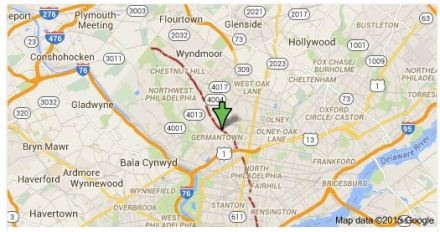
As you can see from the map, Route 23 runs largely in a two-way pairing on 11th and 12th Streets from its terminus in South Philadelphia through Center City, then switches onto the diagonal Germantown Avenue, running northwest to the tony Chestnut Hill neighborhood. The route is also very long for a local bus, almost 14 miles. As a result of the length and Philly’s notoriously narrow and congested streets, Route 23’s on-time performance in 2012 was only 64%, fairly atrocious by transit standards. As a result, SEPTA is considering splitting the historic route in two, with one branch running from Center City to Chestnut Hill and the other from Center City south. Since–as Blumgart documents–virtually no riders use the whole route, there seems to be little opposition to this change.

And that leads me to thinking about the viability of super-long local bus routes in other places. I used to commute on the Chicago Transit Authority’s #49 bus, the core service on Chicago’s uber-long (24ish miles) Western Avenue. Where Route 23 is scheduled to cover its 13.8 miles in about 1:15, for an average speed of roughly 11 mph, CTA’s 49 is even slower, scheduled to cover its 15.7 or so miles in 1:30, for an average speed just under 10.5 mph. Aside: this means that the CTA 49–which has, in the past, extended past its current terminal at Berwyn all the way to the Evanston Line, about 3 more miles–is both longer and slower than the much-maligned Route 23. Unsurprisingly, the 49 is a massively unreliable route, with bunching common. Since the cancellation of the former X49 limited a few years ago, it is the only transit option in the corridor, and one of the most popular routes in the city, carrying even more people than the 23.

The problem with the 49 is that, unlike the 23, there is no especially convenient place to split the route in the middle. I’m sure relatively few people ride the route from end to end, but there’s no point where the entire bus empties out and exits, as happens to the 23 in Center City. Additionally, I will personally testify that having more splits in the route would be a massive pain in the ass, since having to transfer from the 49A and 49B extensions to the core route in order to continue a linear journey is already a major problem. The 49’s reliability problems can’t be dealt with by cutting the route in half, so what options are left for the CTA and other operators faced with similar long-route challenges? (that’s a genuine question!)

The other thing that’s intriguing about Route 23, of course, is that its northern half runs along Germantown Avenue, a diagonal street that once connected that neighborhood to the Philly waterfront. Though Philly’s grid isn’t as regular as, say, Chicago’s, Germantown Ave. still stands out as an oddity on its generally northwest-southeast path.

Germantown Ave. highlighted, from Google Maps

Germantown Ave. highlighted, from Google Maps

Germantown Ave.’s odd alignment–and its Phillyish narrowness–makes it a challenge for fast, efficient transit–but an opportunity for other things, as James Kennedy of Transport Providence, a Philly native, pointed out:

https://twitter.com/TransportPVD/status/590903506439122944

https://twitter.com/TransportPVD/status/590904084925931520

https://twitter.com/TransportPVD/status/590910894193913856

This is a question that intrigues me, since Chicago’s notorious diagonal streets have proven to be a major challenge for traffic of all types in that city. Of course, Chicago’s diagonals are more regular, such that they often cross two other arterials in a nightmarish six-way intersection. Witness Lincoln, Damen, and Irving Park:

Or Lincoln, Ashland, and Belmont:

Among other terribleness, the new Google Maps is temperamental about embedding, so you get a JPEG for this one.

Among other terribleness, the new Google Maps is temperamental about embedding, so you get a JPEG for this one.

These intersections are horrible for pedestrians, create massive traffic jams, and just generally suck. And there’s not too much the city can do about them. The problems at the intersection of Damen, Fullerton, and Elston are so bad that the city is spending millions to realign the intersection, but low-value industrial land isn’t usually available to do that.

Chicago DOT's graphic explanation of the Damen-Elston-Fullerton realignment.

Chicago DOT’s graphic explanation of the Damen-Elston-Fullerton realignment.

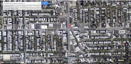
Perhaps the boldest initiative Chicago has ever undertaken to tame one of its diagonals was the 1978 pedestrianization of a short stretch of Lincoln Avenue (no, not all of the horrible intersections involve Lincoln, but it does have many of them) southwest of the intersection with Lawrence and Western, creating the Lincoln Square (mostly) pedestrian mall, the core of one of the city’s hottest real estate markets:

western lawrence

Perhaps the Lincoln Square mall has been buoyed (and to tell the truth, it hasn’t exactly been a smashing success) by being next to the busy Western Brown Line station. But it might also represent the potential of a new approach to those problematic diagonal streets. The luxury of a grid is that it often works best without diagonal streets cutting through it at angles that are either random (Germantown) or too regular (most of Chicago’s diagonals). Surely, the idea of making these streets into a transit, bike, and pedestrian mall is radical. But it may be a really good idea.

Searching for a Good Albany-Area Amtrak Station Site

Albany has a train station problem.

Surprising, maybe, considering the beautiful and (by train station standards) more or less brand new (opened 2002) Albany-Rensselaer station, which typically ranks 9th or 10th out of all Amtrak stations in annual ridership. But true nonetheless.

A few days ago I got into a brief Twitter discussion with the illustrious Cap’n Transit about the state of the Albany train station:

https://twitter.com/yaquinaboy/status/483288333729398784

This is, of course, an entirely theoretical discussion. Amtrak and CDTA, which owns the station, are heavily invested in the current Albany-Rensselaer station, and moving it at this point would be a waste of relatively recently spent infrastructure dollars.  In Albany, of course, politics plays into everything; the Rensselaer station is, to a large extent, one of the many fruits of that notorious porkmaster, former State Senate Majority Leader Joseph Bruno. It is, however, exceptionally difficult to get to by any mode other than driving, despite being only a mile and a half from downtown Albany (if you don’t believe me, just read the comments on this Times-Union blog post). CDTA buses arrive only four times an hour at most, and rather than coming into the station as originally planned they stop on the street outside, in a completely non-intuitive location. Walking what should be a decent distance to downtown Albany or the Empire State Plaza requires crossing the Hudson on the concrete hellscape of the Dunn Memorial Bridge, itself a monument to highway plans that would have done irreparable damage to Albany had they gone through fully.

So the location of Albany’s train station, not to put too fine of a point on it, sucks. The question of moving it may be entirely theoretical at this point, but it’s an interesting question nonetheless. If I were given significant power to physically reshape the Capital Region (like, say, Nelson Rockefeller in the ’60s), where would I put the crown jewel of the region’s non-automobile transportation system?

Albany, of course, once had the downtown station that the Cap’n and I both wish could still exist. The building, in fact, still exists, and it is quite stately:

via Wikimedia Commons

via Wikimedia Commons

Abandoned as a railroad building in 1968, Union Station has seen use as a bank headquarters, and after sitting empty for a while is now being converted into something called “the SUNY College of Nanoscale Science and Engineering’s Smart Cities Technology Innovation Center, or SCiTI.” Once upon a time, New York Central trains (Delaware & Hudson was the other major tenant) reached Union Station from Rensselaer via the Maiden Lane Bridge, like so:

Today (well, as of 1968), the Maiden Lane Bridge is gone, and the area behind the Union Station building, which once held coach yards and two levels of platforms, looks like this:

The approach to the old Union Station, like the rest of the Albany waterfront, has been entirely amputated by I-787, with the only remaining rails, the old D&H Colonie Main, relocated to the middle of the freeway, completely inaccessible from the street. The old platform canopy now shades (a little) a parking garage.

The issue with a downtown station, then, is that not only is the old site unavailable, but so are any other potential sites along the waterfront–that is, any site close to downtown Albany.  So, where CAN one put a station in Albany proper?

One possibility is near the  much dreamed-upon Central Warehouse (proposals for reuse have included an aquarium. Yes, an aquarium), just west of the Livingston Avenue Bridge across the Hudson, on the northern fringes of Albany. The station could occupy the site currently used by the burnt-out hulk, or the short straightaway a little to the west between Broadway and Pearl. The site looks like this:

This wouldn’t move the station very far, of course, but it would get it across the Hudson and into an area with better transit service. The area around the Central Warehouse is seeing a limited revival as part of a brewery neighborhood, but is clearly in need of significant revitalization that a train station could bring. That being said, it’s still pretty far from downtown (about 7/1oths of a mile), and there are a few engineering challenges: platforms couldn’t be very long because of the curves, and it’s not at all clear that the necessary four tracks could be squeezed into the existing right-of-way.

The truth is, though, if we’re looking for a station location that will attract the most ridership, downtown Albany may not offer the most potential in any case. The 2012 ACS numbers show only around 1,100 people living in the census tract that covers Downtown, and while the city has been doing a good job of trying to attract high-end residential conversions to the area, that process had been going very slowly. When I get off my bus coming home from school in the evenings (in Center Square, a little up the hill), I’m always surprised to see that I’m one of the last 2 or 3 people on the bus; non-commute demand to downtown is just exceptionally weak. The truth is that most Albany transportation demand resides uptown, in the dense neighborhoods along Central Avenue, and the more suburbanized areas near the uptown SUNY campus.

Is there, then, a fringe station location that might have something to offer? The idea of a station in suburban Albany is not new; one existed in the large suburb of Colonie for a number of years in the ’60s and ’70s (I can’t seem to find a source for an exact opening date), closing in 1979.  Technically called Schenectady-Colonie, since due to cost-cutting measures it replaced the downtown Schenectady station, this little stop sat about halfway down the passenger main between Albany and Schenectady, very much in the middle of suburban nothingness:

Needless to say, the Schenectady-Colonie station was a ridership disaster from the beginning. (click on the linked article–come for the vintage-1979 Turboliner picture, stay for the speed and trip-time promises that are remarkably similar to today’s!) After hemorrhaging riders for years, the Schenectady-Colonie station closed for good when enough government money became available to build the existent Schenectady station, which sits on the remains of the one that was torn down under Penn Central, and is now slated for replacement itself. In any case, the Schenectady-Colonie station building still exists; the building in this picture is clearly the same one visible at center if you zoom in the map above far enough.  Of course, no station will ever be built there again; it has zero access to public transit, is in the middle of nowhere, and sits smack dab in the center of a long tangent that allows trains to exercise their full 110-mph speed.

So is there a single location for an Albany-area station that I think might be better than the current one? Given the paucity of options, I’m not sure that anything short of a total rebuilding of the Albany waterfront that brings trains back and eliminates I-787 (something I’m for, by the way) can really do the job to full satisfaction. There is one site, though, that might, to some extent, bring benefits greater than the current setup. If it were up to me, I would put Albany’s intercity train station in the empty triangle of land described by Central Avenue, the tracks, and the borders of the Railroad Avenue industrial district, just across the city boundary in Colonie:

This site has room for four tracks, is adjacent to Central Avenue, the area’s main drag, with its BRT-lite BusPlus service (as well as local service), and offers potential for development. It’s also not far from the UAlbany campus, which is a major ridership generator. It’s also just past the top of the slow, curvy climb out of the Hudson Valley, and thus stopping there won’t cost trains as much time as slowing in the middle of the sprint from or to Schenectady. The site is also a brownfield, formerly home to a National Lead plant that was shut down by the state courts in 1984 for polluting; amazingly enough given its proximity to homes, the plant was found to have been using depleted uranium and other radioactive materials in its work, and so the site has for the last 30 years been under the stewardship of first the federal Department of Energy and then the Army Corps of Engineers. With its rather notorious history, the prospect of redeveloping the National Lead site as housing is probably unappealing. But the site is transit-accessible, central, and offers the prospect of being the lever that can bring the Central Ave. corridor in Colonie into a more urban future. If magically the prospect of moving the Albany train station becomes realistic, this location has my vote.


Existing Parking Under-Utilized? Add More! The Story of Albany’s Park South Redevelopment

A couple of months ago I wrote a post about the parking crater that dominates the area around Albany Medical Center. Blaming the sacrifice of so much potentially valuable urban land to parking lots, I wrote a paragraph I’m now quite proud of:

What makes the Park South project even more galling is the presence of so much other essentially empty land around AMC and its sister institutions. If anyone were able to unite land-use planning for all of the parcels now used as parking, AMC could avoid ripping out old buildings in Park South and share with the other institutions an enormous parking structure (if it’s even needed!) that’s nowhere near residential areas. Instead, it appears that the city has declined to force the various institutions in the area to cooperate, and instead allowed institutionally individualized, and therefore wasteful, land-use plans to go into action.

I went on to argue that Albany should be encouraging redevelopment of those vast parking lots as a real, walkable urban neighborhood. I stand by that assertion, but in this post I want to focus more on the questions I raised in the above paragraph. The impetus is the release of a City of Albany-commissioned report on parking and transportation demand management (PTDM) in the area, focusing in particular on Albany Med’s plans for urban-renewing a large swath of the adjacent Park South neighborhood.

Let’s begin with the question of whether the planned Park South garage (now planned for almost 1,000 spaces) is even necessary. Without saying so explicitly, report contractors Nelson/Nygaard, a prominent planning and transportation consulting firm, say pretty firmly that the demand just doesn’t exist. Looking at the area within five minute’s walking time of the proposed project area, the consultants measured existing parking capacity and utilization thus:

PTDM Report, p. 9

PTDM Report, p. 9

Even at the peak time of 11:00 AM, there were more than 1,500 empty spaces within a 5-minute walk of the Park South project area. And that’s not including the AMC-owned “satellite” lots, which are located less than a ten-minute walk away (there’s also a shuttle bus). Those hold almost another 1,500 cars, and, according to the TDM report, always have excess capacity. As for added demand from the new office and residential buildings proposed for the Park South project, even the most conservative assumptions, derived from the Institute of Transportation Engineers (ITE)’s suburban-style standards, assume at most 822 new spaces would be needed (and remember, the developer and AMC are planning nearly 1,000).

The clear implication is that if one looks at the AMC/Park South neighborhood as a whole, rather than just considering the institutional resources and perceived needs of AMC itself, the added parking from a massive new garage in the Park South project would be entirely unnecessary; any added parking demand could be easily satisfied by existing excess capacity. Even if, as predicted by ITE guidelines, 822 more cars magically materialized as a result of the Park South development at 11 AM every morning, parking occupancy in the area would still be just 88%–within industry accepted standards of 85-90%. If the satellite lots are included (as they should be), the figure would be even lower, though exact numbers seem unavailable. Of course, if proper measures are taken, new demand won’t come close to 822 new cars every day, according to Nelson/Nygaard’s report: “If the development has a TDM program (as recommended below), the parking demand would be about 515 parking spaces (plus valet), which would translate to a supply of about 640 spaces – about 280 less than proposed. This assumes a 20% internal capture rate and a 15% TDM program reduction.” These smaller numbers, obviously, would be even more easily accommodated by existing parking in the area.

Alas, looking at the AMC area as a whole, rather than as atomized parts, has clearly long been the bane of Albany’s land-use and parking policy. In my previous blog post, I used a capture of a segment from Albany’s handy-dandy institutional land-use ownership map to demonstrate the fragmentation of land ownership, and therefore coordination, in the area:

AMC ownership

Ouch, right? Predictably (via the TDM report), this fragmentation leads to total lack of coordination in parking, with different parking lots in the area owned by several different institutions, and no attempts at cooperation:

parking_fragmentation

When the companies involved in the redevelopment project assert that the project is infeasible without adding the garage, they’re considering the issue only from the perspective of the resources available to AMC, not to the area as a whole. And that’s the kind of mistake that can be disastrous for a city.

The policy implications of the TDM study, then, are pretty darn clear. When neighborhood context (and not the kind that implies “everything in the neighborhood must look alike”) is taken into account, there is more than enough parking supply in the neighborhood to meet peak current and any expected future demand, even if the Park South project is fully built out. The massive parking garage planned for Myrtle Avenue is completely unnecessary, and reflects the worst pathologies of midcentury American urban design: atomized institutional self-interest, accommodation of perceived rather than actual parking demand, no attempts to conceive of alternative ways of accommodating growth in transportation demand.

That being said, “don’t build the garage” isn’t a full policy response.

The primary challenge to parking management in the AMC area is the fragmentation of land-use policy and lack of cooperation between the area’s resident institutions. The City of Albany should establish a commission or task force to regulate transportation management in the area, with representatives from each of the major institutions in the area (AMC, CDPC, the VA Hospital, Sage College, Albany Law—I’m sure I’m missing some), the city planning department, and neighborhood residents. This body should be given power over (if not actual ownership of) ALL of the parking resources in the area, with a mandate to streamline and unify management and control.

The savings from not building the garage stand to be considerable, and should be able to fund a kick-ass TDM program for years to come. At national average costs of around $15,000/space, the cost for the proposed parking garage is probably approaching $15 million, a significant chunk of the overall $110 million project cost. The TDM study mentions that the developers and AMC have agreed to a $70,000/year Memorandum of Understanding with local transit authority CDTA, with one possible way of spending that money being for the agency to operate 2 additional buses on Route 13 (the primary route serving the hospital) at peak hours, enough to increase frequency significantly. Imagine what CDTA could do with payments of, say, half a million dollars a year to increase service on all of the routes serving Park South and AMC (see below for more transit analysis). Devoting some of the costs that could be saved by canceling or considerably reducing the size of the garage to transit and other alternative modes seems like a win for everyone.

That the Park South project has gone as far as it has without examination of these fundamental points about parking and transportation demand is a signal of the kind of desperation that economically depressed, fiscally desperate cities can sometimes show. Albany can do better. It’s time to stop wasting valuable taxable land and inviting more cars into Albany.

A Few Additional Points

  • The report makes at least one assumption that is likely to be politically controversial: it counts on-street parking spots on many streets in Park South that are currently mandated for residential permit parking as available resources. Given that the biggest parking problems residential neighborhoods in downtown Albany currently face are at night, and the vast majority of AMC demand seems to be gone by 4 PM, one imagines that residents in the area might be willing to trade their permit protections for the garage not being built, thus adding the spaces on their streets to the overall supply. Alternatively, AMC and the city could work out a deal where AMC workers could pay for on-street permit passes; many small businesses in the adjacent Center Square neighborhood own parking permits, and the point of Albany’s permit parking program is to keep out state workers in the Empire State Plaza anyhow.
  • The report mentions that as of 2008, only 2% of AMC employees took transit to work, a shockingly low number for a medical center in an urban area (though that number has probably gone up since the establishment of Route 100, connecting the city’s poor South End to AMC). Truth be told, AMC isn’t in the best location for transit; it’s around a mile from the city’s biggest transit hub near the corner of Lark and Central, just far enough to be inconvenient.  The report recommends re-routing the only “trunk” route (it still doesn’t run very frequently) serving the area, the 13, away from Holland Avenue to serve all of New Scotland; this seems like a good idea. Increasing the frequency of the #114, which currently runs twice an hour, and straightening it out so it runs down the length of Western and Madison seems like a good idea as well. According to the map (by zip code) provided in the report, which local blog-of-record All Over Albany correctly emphasized as one of the most interesting parts of the entire report, the heaviest concentrations of AMC employees are in neighborhoods centered on Western Avenue, which currently does not have an all-day direct bus link to AMC; re-routing the 114 from Washington to Western would provide this link.  Via Park South councilwoman Leah Golby, who has doggedly fought for transparency and good urbanism in the redevelopment process, it appears that AMC is preparing to enter into a Universal Access Agreement with the CDTA, which was also one of the report’s recommendations; that’s a good first step.
  • Report consultants Nelson/Nygaard also call out AMC for, essentially, not providing remotely adequate facilities for employees biking to work. That seems like a no-brainer, but it’s sadly typical of the unthinking attitude most Albany institutions seem to take towards biking (and I say this as someone who has never learned to ride a bike).  AMC is just two blocks from Albany’s first proposed road diet, which would provide the city’s first real bike lanes; it’s an obvious connection.
  • As I said on Twitter, Nelson/Nygaard deserve huge props for an unstinting, well-researched, and above all honest study, as do the members of the Albany Common Council who pushed for it. At a certain point, Albany has to start looking out for itself rather than submitting to the (often 40 years out of date) viewpoints of the institutions that call the city home. Hopefully—just maybe–this is a turning point.