Some Updates

Well, it’s been a long time! I haven’t had much time or motivation to write, but hopefully that will begin to change some time soon. Famous last words.

Alert observers who for some reason follow me extremely closely may have noticed that my employer has a job listed that covers my major responsibilities–namely, managing the Boston MPO’s federally required budget plan. That doesn’t mean that I’m leaving Boston or MPO work, though! I’ve been at CTPS for almost five years, and I’m taking on some new responsibilities that I’m very excited about, and that I’ll get to in a moment. But first, apply for the position! It says you’d spend 60% of your time working on the UPWP (roughly accurate, though it’s highly concentrated in the January-June band) and 40% as a resilience planner. There’s likely some flexibility in the second element, but it’s a skillset we need on staff badly. I’m happy to answer questions from anyone who’s interested; you can find me on Twitter or through the contact page on this site. The position is open until October 28.

We’re also hiring for two other positions in my work group, both related to outreach and communications:

Manager of Outreach and Communications, a newly created position, will oversee a small department. This position is open until October 20.

Public Outreach Coordinator will work for the new manager and pick up much of our important outreach work, in partnership with other staff members.

As for me: I’ll be taking over lead management of the MPO’s Transit Working Group (next meeting on October 12!) and transitioning into the role of being the MPO’s freight planner. Neither of those is a full-time job and I’ll be doing other things, too, but those will be my core responsibilities. Freight in particular is something that, while I’ve had a long-standing interest in it, is relatively new to me, so please send along resources. Anything on general freight and logistics is welcome (I already know a lot about freight rail, which is a relatively minor player in the Boston area these days), but I’m especially interested in examples of public-sector freight planning.

Gratuitous Pretty Picture

The picture at the top of the post features the old Niskayuna, NY train station, built in the 1840s by the Troy & Schenectady. Now an artist’s studio next to the very popular Mohawk-Hudson Bike-Hike Trail. Picture taken in August.

Democratic Planning in the Age of Urban Freeways and Today

I finished reading two very different, but equally interesting and informative, recent urbanist-y books over Shabbat. The first is Akum Norder’s The History of Here, a fun and talented Albany writer’s look into the history of her family’s house, the people who have inhabited it, and the life of the neighborhood around it. The second is Karilyn Crockett’s People Before Highways, an ethnographic and historical look of the anti-freeway movement in the Boston area in the 1960s and ‘70s. Both books are worthy of a full-scale review that I may or may not be able to undertake at some point, but I wanted to pull out a common element that I think makes for an interesting, and very relevant, point of discussion: the question of how democratic planning should be, and how that should look.

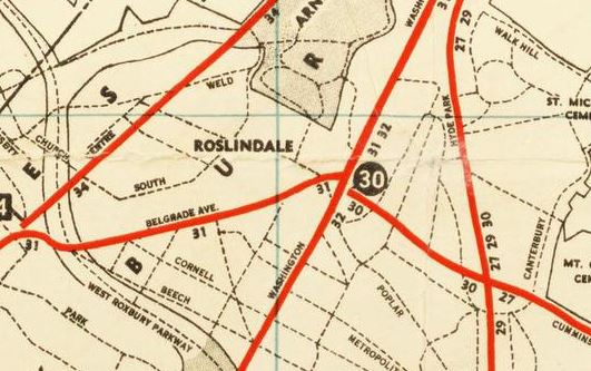
Let’s start with People Before Highways. Crockett’s work is essentially an ode to the grassroots anti-highway backlash that transformed transportation policy in Massachusetts and led to the end of freeway building inside the Route 128 beltway and the ability to “flex” federal transportation spending from highways to transit. Boston’s anti-freeway coalition was a broad–and varying at different times–group of institutions, scholars, “radical” planners like future Massachusetts Secretary of Transportation Fred Salvucci, and community members. The last element is perhaps the most interesting; participants ranged from tenant activists in public housing to Black Panthers to patricians in Brookline and Cambridge to people we would now identify as first-wave gentrifiers in the South End and my own neighborhood of Jamaica Plain. This coalition demanded not just an end to highway building, but also to the heavy-handed way in which the freeways had been planned, and significant amounts of land taken, with virtually no opportunity for public input. Crockett wastes no opportunity to remind the reader that the demands of the Boston anti-highway movement were not just specifically anti-highway, but processually radical and progressive in their insistence on the distribution of power.

Certainly, the righteousness of the Boston anti-highway, pro-public participation cause is not in dispute; it’s a difficult book to read for a professional planner. One thing that strikes me about Crockett’s work, though–and it’s a problem I’ve seen elsewhere in leftist planning thinking and writing–is that her narrative is shaped by a powerful nostalgia for the kind of grassroots planning and localist democracy that her subjects believed in, but doesn’t engage with some of the potential challenges of a highly democratic process. Indeed, some of the potential challenges with such a process show up even within her own research. In the sixth chapter of the book, Crockett profiles the planning process around the creation of the Southwest Corridor linear park, by all accounts pretty much a triumph of democratic planning that created a valuable community amenity and showpiece to this day. The cracks in the process of democratic planning, though, show through this account. Crockett shows how the South End community was able to demand that the Southwest Corridor trench through their area be roofed over to reduce noise, pollution, and vibration. This is, of course, not an unreasonable ask–but Crockett’s account makes it clear that the presence of educated, middle class people in the neighborhood, including some who we would clearly call gentrifiers today, was what got the deck built in that section, but not elsewhere in the Southwest Corridor. Why, one thinks today, is the trench not decked through Roxbury and Jamaica Plain? I lived a block from the trench for my first 10 months in Boston, and one can feel the vibrations and hear the roar from passing trains. A purely “democratic” planning process is already one that gives greater voice to those able to shout loudest–and Crockett’s account of the decking of the South End trench shows how this can lead to opportunities being available inequitably.

Crockett also narrates the process for planning the park that went on top of the South End trench, and if anything it reveals more of the cracks in the facade of democratic-planning-as-magical-cure. She writes:

By removing the railroad’s stone embankment and inserting decking along segments of each section of the Corridor, the Southwest Corridor planners knit together neighborhoods that had been physically separated for more than a century. Not every resident viewed this as social progress…The existing railroad right-of-way created a dividing line between the South End and St. Botolph neighborhoods. Though these two areas held only slightly different economic profiles, their racial and ethnic compositions could not have been more different. St. Botolph residents constituted a largely homogeneous block of white families and some professionals working in the city. Though they themselves were city dwellers, many St. Botolph residents looked askance at the idea that deck cover would allow other urban neighbors easy access to parts of their neighborhood previously blocked by the railroad. These residents used the Corridor’s public meetings to voice their opposition. (p. 187)

In other words, the residents of St. Botolph engaged in fairly standard-issue urban racism, classism, and (one would imagine, given the increasing gay population of the South End at the time) not a small amount of homophobia–and saw in the democratic Southwest Corridor planning process an opportunity to (very democratically!) write their oppressive agenda in concrete. Unfortunately, Crockett’s handling of this rather obvious challenge to the viability of democratic planning is less than inspiring. 

By listening and respecting the concerns of residents, [Southwest Corridor planners] were able to identify an architectural strategy that was responsive to the demands of St. Botolph’s residents but did not subvert the overall public planning agenda for the Corridor…[they developed] designs for a removable fence that could be unbolted at a later date should the neighborhood change its mind. Unfortunately, the design was compromised by another decision to lay granite at the base of the fencing, and when St. Botolph’s residents did, in fact, reverse their decision and requested direct access to the Corridor Park, it was no longer possible. (p. 188)

One must, I suppose, applaud the Corridor planners for their commitment to democracy, inasmuch as they were committed to listening to, to the point of acting to some extent on, an obviously bigoted agenda. To this day, many streets on the western side of the Southwest Corridor in this area dead-end at the Corridor Park with a wall or fence of some considerable height rising to prevent what should be an obvious pedestrian connection.

blackwood barrier

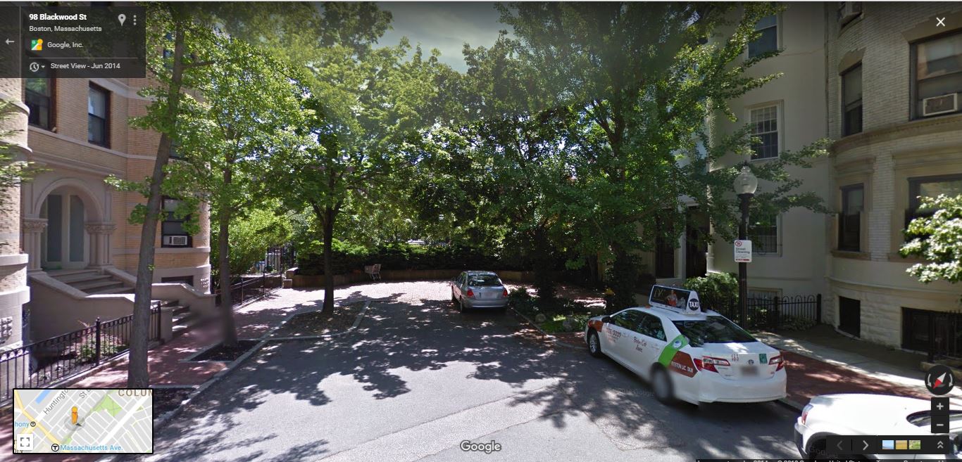
A democratically erected barrier preventing easy pedestrian access to the Southwest Corridor Park, Blackwood Street, Boston.

Crockett calls this “The seeming contradiction of a connective landscape needing to reconcile itself with existing race and class divisions and residents’ divergent opinions about what to do about them,” (p. 188) but–especially as one of the direct inheritors of the conflict around transportation planning in Boston–this feels like an unsatisfying resolution to me. Many of Crockett’s interviewees for the book talk about how they saw themselves as “advocacy planners,” adherents of a mid-’60s theory that planners should not be impartial experts, but advocates for the oppressed in society. It seems to me that there’s an obvious tension between this identification and engaging in a planning process that encodes racial and class injustice (literally building fences!) in the built environment in the name of “democracy.” While incredibly valuable for its documentation of the Boston anti-highway movement, and its repetition of the lesson that megalomaniacal centralized planning is generally abusive, People Before Highways would be more useful and convincing if it grappled honestly and openly with some of the shortcomings of the democratic, grassroots visions of planning that it advocates.

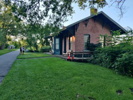
Akum Norder’s book, too, offers a lesson on this topic–and perhaps the juxtaposition of the two narratives can allow us to draw some conclusions about the intellectual and social milieu of participatory planning and its challenges. Norder’s book is an ode to her Pine Hills neighborhood, an absolutely lovely streetcar suburb-era area that reminds me strongly of the Westville section of New Haven where I grew up. Pine Hills originally and today is a strongly middle-class area with a strong communal identity; but it’s had its ups and downs, borders the “student ghetto,” and generally has some reasonable fear of tipping into neighborhood decline in the same way that most middle-class areas in cities that aren’t part of the overheated coastal housing markets do. As such (and seeing that many of the residents are educated, have money, or both), these neighborhoods are ripe for democratic, grassroots organizing around the issue of perceived problems–and using a democratic planning process to deal with them in a way that may work well for the neighborhood but not always for those pushed out as a result.

Norder profiles one such case (though without the slightly negative valence I’m attaching to it). She writes, on pages 204-205, of a property on the corner of North Allen and Lancaster that, at 5,921 square feet, held by the early 2000s twenty-six units. That is, of course, far more than current zoning would allow, but most of the neighborhood is nonconforming and grandfathered anyhow. Normally, such properties can continue unmolested unless the owner requests a change of use or makes major modifications; but city code allows for the property to be forced into conformance if it’s declared a nuisance property. And since the building in question does appear to have genuinely been a nuisance property, generating fights, noise, and an astonishing number of police calls, the local neighborhood association took the opportunity to force a zoning board hearing. They won, and the landlord had to empty the building to cut its units down to the allowed two.

So, on the one hand, this is a victory for a democratic planning process and for community concerns. The area residents took on a nuisance landlord, used the objective rule of law, and made their neighborhood a better place. Bully for them–we should encourage everyone to care about their neighborhoods like that. On the other hand, we’re talking about a process–a very democratic process–that led directly to the eviction of at least twenty-four people, with those who provoked it presumably taking no financial responsibility for their relocation. This being Albany, where rents are generally cheap, I think it’s reasonable to assume that few of those people were displaced from the area entirely; most were probably able to find housing relatively close, and quite possibly at not much increased rent. So the result isn’t necessarily the worst. But what if it weren’t Albany? What if this were a property in Boston, where rents are triple or quadruple what they are in Albany? Would we tolerate a neighborhood group getting together to democratically destroy what’s effectively an SRO, a vanishing resource for the very poor? How should a progressive advocacy planner react to this scenario?

I don’t have a coherent set of answers to these questions yet. But I think they’re crucially important to ask. And I think it’s important to recognize that the historical and socioeconomic context in which calls for grassroots, democratic planning came around has in many cases vanished. The type of democratic planning Kaitlyn Crockett profiles so well was a product of a city under siege, under threat of imminent literal physical destruction. Places like Albany may well still feel a lessened version of that threat. But in Boston, today, it’s gone. There is still a threat of displacement and destructive change, but it comes from the opposite end of the spectrum, from a hyperactive real estate market and the desire of many more people than the city has been willing to build housing for wanting to live here. Already in the time period that Crockett narrates privileged voices were figuring out how to use the democratic planning process to subvert planning aims of social justice and integration. We can’t, and we won’t, throw out the baby of democratic planning and extensive public outreach with the bathwater of urban renewal and highway building.  But we can, and must, recognize that there are tensions between promising all comers a democratic process and achieving egalitarian, democratic outcomes. Just this past week the Globe wrote about how Boston’s input-based sidewalk-repair system is failing poorer neighborhoods that are less likely to call in for repairs. Is it possible, one must ask, that planners again need to start putting our thumbs on the scales of justice–this time, to tip them back toward the right?

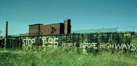
Featured image source: https://www.jphs.org/transportation/people-before-highways.html

Ironies of Highest and Best Use

I went to the Roslindale Square/Village RMV to convert my NY license to a MA one yesterday. While I successfully converted the license, the trip was a pain because a) I was available to do it because I was home sick from work and b) the RMV has clearly not learned the lesson I keep tweeting at transit agencies, that inaccurate real-time estimates are worse than none at all (I was given an estimate of zero wait and ended up being there for 45 minutes, standing the whole time in a room that was incredibly hot and smelled strongly of pot and people). It did, however, give me a chance to check out the area some, and in particular (the exterior of) a building I had wanted to see, the former Boston Elevated Railway Company substation at the corner of Washington Street and Cummins Highway.

A substation, you might think, would be a boring and utilitarian building. Not so! Remnants of traction systems past–and there are many, since the power systems (as opposed to the tracks) tended to be heavily built–were in fact often elaborate in design and construction.

wp-1488927803337.jpg

The Roslindale Substation, from Adams Park across the street.

The Roslindale substation features beautiful brick construction and high, arching windows; while it’s clearly a building with an industrial history, it’s the furthest thing from today’s functional but ugly boxes. Most interestingly, perhaps, the substation occupies a place of honor and importance in Roslindale, at the intersection of two busy streets (and transit corridors) and in the absolute center of the neighborhood.

rozzie

On the one hand, this makes sense, since several trolley routes historically converged at this corner, as seen in a 1936 map:

ros square substation 36

On the other hand, it seems like placing a substation–as opposed to, say, storefronts–on such an important corner would have been a terrible violation of the zoning/real estate principle of highest and best use, although it should be said that the substation was built in 1911, before zoning swept America. To a certain extent, surely, the substation’s location was the product of a disconnect between transportation and land use; from their own perspective, it made perfect sense for BERy to place it there in 1911. And for much of the building’s history, demand for land in Roslindale Square was relatively low; it was, after all, vacant for 45 years, until just this year. But–and here’s the irony the title of this piece refers to–the area is now somewhat up-and-coming, and the substation is now in the process of being converted to commercial use (an already-open craft beer store and a restaurant to be called the Third Rail), with the remainder of the lot taken up by new apartments. As the planner’s proverb that I just made up goes, every lot finds its highest and best use, sometimes it just takes 106 years.

Interestingly, much the same story unfolds just a few miles down Washington Street toward downtown Boston, with BERy’s former Egleston Square substation.

Egleston substation walgreens

Like Roslindale Square, Egleston Square historically represented the convergence of several transit lines, and was thus a logical place to put a substation. Unlike the Roslindale substation, this one served both streetcars and the Elevated, and thus remained in service until the closure of the latter in 1987. Like its more southerly counterpart, though, it fell into abandonment and ruin thereafter, until being resuscitated in 2008 to serve as the studios of Boston Neighborhood Network Television. As you can see from the Streetview capture above, the building is a remarkable contrast to the low-slung, suburban-style Walgreens next door–the high-quality architecture of a century ago continuing to pay dividends. While Egleston Square as a whole is not the world’s most urban-feeling built environment, the substation should–after nearly a century of life as an industrial building–be able to help anchor its rebirth in its new role.

If there’s a point to this post, other than that people do interesting things with old trolley substations, it’s that good architecture endures and tends to lend itself to a positive use in the long run. Like life, land-use dynamics are unpredictable and changeable, which is (part of) why locking uses and styles forever, as American zoning slanted toward single-family uses typically does, is a bad idea. Did the architects who designed the Egleston and Roslindale substations in 1909 and 1911 ever imagine the buildings being adaptively reused for another purposes? Unlikely, although they were clearly built to last. This is not to say that every abandoned building can or should be reused, but it’s a useful reminder of the way demand for land can change over the course of a century. And who knows? The Go Boston 2030 transportation plan, released just today, calls for rapid bus lines to pass both substations. Though they’ll most likely never power trolleys again, both substations could again serve an important transit-oriented use (as they do relative to local bus service today), as attractions drawing people to their neighborhoods along the transit corridors of the 21st century.


Notes on Central Florida

I spent last week on vacation in the exurbs of Orlando (well, really Kissimmee) with my partner’s extended family. Since theme parks are, well, really not my thing, I spent a decent amount of time thinking about the planning and urbanist implications of an area that I found frankly fairly miserable from a built environment perspective. I don’t so much have an overarching argument here as a series of notes on a few things I found interesting.

Pod-based building

We were based at a resort called the Vacation Village at Parkway, off the arterial Irlo Bronson Memorial Highway (US 192) west of downtown Kissimmee. In many ways, the sprawling urban form along that road is typical of suburban land use across the country, though perhaps in an exaggerated form. Developments occur in pods, completely disconnected from one another along property lines. Take, for example, this pathetic excuse for a pedestrian crossing from “our” resort to the strip mall and resort next door:

wp-1483453028351.jpg

Mind you, one has to traverse this after crossing four lanes and a median of road without a crosswalk of any sort.

The area in which our resort was located is also cut off from its surroundings in a more profound way. It shares a triangle of land with several other developments; the sides of the triangle are defined by I-4 on the west, Bonnet Creek on the east, and 192 on the south. But grid connections–and ways to exit–exist ONLY on the southern side, to 192.

vacation-villages

That turns what could be an easy stroll over to the as-the-crow-flies-neighboring Gaylord Palms into a 1.8-mile odyssey along high-speed arterials:

vacation-villages-gaylord-palms

such that Google Maps literally cannot calculate walking directions between the two. This area of Kissimmee is to the south of most of the major Orlando-area attractions, so this kind of thing also lengthens the (many) car trips taken between resorts and said attractions, resulting in even more congestion in an already congested region. It’s just thoughtless–and the result of a zoning regime that emphasizes massive parking lots and setback at the expense of all else, including common sense.

Latent demand for car-free vacations

Despite a built environment that seems to invite, or even mandate, car use at every opportunity, it’s clear to me that there is a latent demand for car-free travel from tourists that could be better met. Transit service in this part of Kissimmee is not completely hopeless, but it’s far from perfect. You can catch a bus to Lynx’s Kissimmee hub four times an hour from the corner of Irlo Bronson and Celebration Boulevard, and they’re even nicely spaced much of the time.  The bus stops are nice too:

bonnet-creek-station

But service on one of the lines stops by 10 PM.

There’s also a whole network of resort-contracted shuttles that ferry people to and from theme parks, shopping, and entertainment. The vaguely vintage-styled coaches of Disney’s Magical Express, connecting their resorts to the airport, were ubiquitous on the highways, for example. Vacation Village provides shuttles to theme parks, as well as more local destinations.

wp-1483453716583.jpg

At the same time, the entire built environment–from single-use zoning to massive setbacks to street and grid geometry–basically mandates car use for the vast majority of trips. I’ve spent more of my life in sprawly suburbia than I really would like, but I got a sense for a latent demand for less autocentricity here more than anywhere else.

Celebration is…Weird

Vacation Village is basically across the street from Disney’s much-debated attempt at New Urbanism. Celebration occupies a bizarre place on all kinds of spectra: more small town than suburb, more private than public, kind of an independent governmental entity but not entirely. I didn’t spend much time there (really just one lunch that was mostly spoiled by rain), but it’s…weird. The built environment blows most of the rest of Central Florida out of the water just by dint of having been thought through even a little bit, but the materials used in the construction of the buildings doesn’t really seem much better than your typical suburb; I saw a lot of sagging gutters and cheap-looking vinyl siding. The main street, such as it is, is touristy but reasonably nice; parking is tucked behind the buildings per standard New Urbanist practice, but it’s still abundant and free. Though not a grid, the street geometry makes more sense than most suburbs. A couple of things jumped out at me, though. This is the main drag carrying cars into Celebration, creatively named Celebration Avenue:

celebration-ave

The speed limit drops to 25 mph as soon as you enter the residential part of Celebration–which is nice–but it struck me that despite a nice, wide ROW Celebration Avenue still has very wide travel lanes (much wider than one would expect for a 25 mph speed limit), and no provision for bike lanes.

The other thing that struck me about Celebration? It has zero transit.

Oh, sure, Lynx’s #56 circles through the much more suburb-y single-use commercial section ever half an hour:

But that’s, like, really far from the commercial and residential parts of Celebration:

celebration-map

Celebration is better than other suburbs, sure, but it’s hard for me to accept the word “urbanist” anywhere in proximity to an area that entirely lacks transit service. I suspect the omission is intentional; simply because of the quality of design, Celebration is extremely expensive, and places like that tend not to welcome transit. Do better.

Toll Roads

I don’t want to comment on this too much without reading up more on the background of transportation planning in Central Florida, but the prevalence of toll roads was a common topic of discussion among the extended family. Certainly, it’s annoying that Florida’s extensive toll road network doesn’t accept the EZPass technology common in other parts of the country; outsiders get fleeced by paying higher tolls, in cash. The tolls didn’t seem especially high but the frequency of booths seems potentially counterproductive. I do wonder if a willingness to toll the roads has led to overbuilding of the network, since they may be less of a drag on gas tax revenues and the general fund.

The Great Sucking Sound

We had an enjoyable side trip to Lake Wales, FL, where my grandfather grew up and my great-grandparents and a great-aunt are buried. It’s a very pretty area made famous by the Bok Tower Gardens, but it’s also a struggling agricultural region whose citrus industry–Florida’s Natural is headquartered in Lake Wales–is not exactly at its peak of glory. Consequentially, downtown Lake Wales is struggling to a certain extent. As elsewhere in the country, that struggle is exacerbated by sprawl, particularly the sucking of retail out to low-rent districts on suburban arterials. 6-lane US 27 is the main north-south artery along the Lake Wales Ridge, and it’s characterized by on-and-off clusters of commercial development that become more consistent as one drives north, approaching the Orlando metro. Just outside of Lake Wales, however, the Eagle Ridge Mall stands virtually alone, isolated among cow pastures and citrus groves.

eagle-ridge-isolated

It’s precisely this kind of thing that kills the functional downtowns smaller towns like Lake Wales need to survive in 2016. And the mall’s 20-year history is full of sinkholes and bankruptcies, so it’s not like the competition is going anyone any favors. The mall’s struggles are likely due to its odd, middle-of-nowhere location (I suspect it was placed so as to draw from both Lake Wales and nearby Winter Haven, but it seems to be doing neither). It’s the kind of sloppy economic development and land use policy that has landed so many places like Lake Wales in trouble.

They Paved Paradise and Put Up a Parking Lot

More than anything else, this is the overwhelming experience of Central Florida:

20161226_142626_hdr.jpg

Just out the back door of our building at the resort. 

That’s a high-rise looming out of a wetlands, which is cynically preserved to be pretty at right. Just beyond the fence, there’s a short drop to very muddy and wet land; the entire building must be built on a slab of concrete or else it would sink into the muck. It’s hard to go anywhere in the area without thinking of Joni Mitchell’s “Big Yellow Taxi.”  Florida’s selling point is, to a large extent, its spectacular natural environment; but its growth as a tourist and retirement destination has been largely premised on the destruction of that environment. I’m hardly the first to point out that paradox, and as someone with training in archaeology, I recognize that destruction is sometimes inevitable. But my overwhelming takeaway from this trip is that there’s a lot of opportunity to just correct things that are sloppy, should political and public will exist. Or, you know, maybe the whole state will just slide into the ocean. That’s always a possibility.

A Walk in the Neighborhood and Urban Albany

It’s drop-dead gorgeous out today, and Wednesday is my day off of classes, so it was time for a walk around the neighborhood. Since the sun is out (finally) I figured now would be a good time to showcase Albany a little bit and comment on some of the (positive and negative) aspects of urban design, planning, and urbanism in the downtown area. All pictures are taken within a mile of my apartment.

Tree budding, Hudson Ave. just east of Lark

Tree budding, Hudson Ave. just east of Lark

One of the the surprising things about Albany is that some of the monumental architecture can make it feel like a much bigger city than it really is (~97,000 people, down from a high of 135,000). Here the towers of the Empire State Plaza–the larger one, the Corning Tower, is 42 stories, and the Agency Buildings are about 20 stories shorter–pop up over the mid-rise apartment buildings occupying the valuable real estate adjacent to Washington Park as we look east down Hudson Avenue. The towers are cleverly tucked into the slope down to the Hudson so that their full height isn’t apparent, but they do put the low-rise Center Square neighborhood into perspective.

wpid-20150429_134900.jpg

Olmstedian (though not designed by Olmsted himself) Washington Park is one of the true joys of living in downtown Albany. Here, the sun shines over the lake that is one of the park’s central features, and over the odd-duck Lake House (now mainly used as a theater), one of a very few Spanish Revival-styled buildings in the area.

wpid-20150429_135424.jpg


Who says modern builders can’t imitate historic styles? I don’t usually walk on the block of Madison between New Scotland and Robin, so while scooting by on the bus I’ve never actually noticed that this townhouse is a relatively recent fake:

wpid-20150429_135638.jpg

Albany has several other infill projects that are well-done imitations of historic styles; it’s something that the city does well. If that offers hope, turning the corner offers despair:

wpid-20150429_135926.jpg

This was really the point of my walk today. The Park South Urban Renewal Plan–yes, we still use that phrase here in Albany–driven by Albany Medical Center has (just since I moved here less than two years ago!) wiped out two whole blocks of homes to put up a new mixed-use development (but mainly just parking). Just months ago, this view would have looked like this:

robin dana

The plans certainly aren’t the worst, but they’re certainly not the most urban-feeling plans either. What makes the project–the beneficiary of state tax credits–particularly outrageous is that the enormous, 800-1000 car garage (the exact size seems to keep changing) you can see under construction in the picture above is completely unnecessary.

More garage, in case you weren't convinced enough of the scale.

More garage, in case you weren’t convinced enough of the scale.

Somehow, a single daffodil survives between concrete, construction materials, and insulation material that's been left out. It's almost TOO #$@#$ poetic.

Somehow, a single daffodil survives between concrete, construction materials, and insulation material that’s been left out. It’s almost TOO #$@#$ poetic.


No seriously, it's really huge.

No seriously, it’s really huge.

What was here before clearance? Nothing particularly special, a few low-rise middle-class homes:

Looking west on Dana about halfway between New Scotland and Robin

Looking west on Dana about halfway between New Scotland and Robin

The Park South neighborhood has been in a rut for a while; many of the houses, including the ones that have survived the renewal project, are in poor shape, and this was never an upper-class neighborhood to begin with. That being said, AMC owns much of the real estate in the area and has been patiently awaiting its opportunity at redevelopment. And major institutions, for-profit or not, that hold on to large swaths of land for a promise of future development over long periods of time are virtually never good stewards; if you haven’t read my early post on Chicago’s The Valley neighborhood, go do so. Granted, it’s an extreme example, but it’s illustrative of the dangers of long-term planning for megablock development.

We’ll close the tour with a picture of something more hopeful, a new mixed-use building (retail on the first floor and apartments above) on the corner of Lark, Delaware, and Madison.

wpid-20150429_141420.jpg

I could’ve gone with two or three more stories of apartments on top, but it’s certainly nothing to sniff at…and there’s no added parking! (the building will share with the condoized historic police station next door on Madison)

Amazing how many issues come up on a brief (1.5 miles total) stroll around the neighborhood sometimes.

Notes on Long Transit and Diagonal Streets

Between school, Passover, and life, I’ve been extremely short on time and (especially) focus to write recently (though I did do a Twitter series about Amtrak reform, Storified here), but I do want to get something up.

Jake Blumgart has a post in the Philly Voice about SEPTA’s fabled Route 23,  the former-trolley-now-bus that connects tony Chestnut Hill in the city’s Northwest with Center City and South Philadelphia. Route 23 has been acclaimed as the world’s longest trolley route, a claim I’m skeptical of, if only because Chicago’s Route 49 (Western Ave.) has run up to 20 miles at times. It’s also a flashpoint of the bus-trolley wars, with some romantics consistently calling for the return of the trolleys that were taken off the route in 1992 (much of the rail infrastructure remains in place). The problem is that, as Blumgart notes in his piece, “When trolleys rumbled along the 23, an end-to-end ride took more than three hours; the bus takes about half of that time.” (I believe that number is somewhat exaggerated–Blumgart got it from long-time riders of the route–but there’s little doubt that the trolleys were indeed slower than buses that can pull into and out of traffic)

Route 23 intrigues me because it combines two particular challenges of urban transportation planning: super-long mixed-traffic transit routes and diagonal streets that cut across the city grid.

Route 23 map from SEPTA's schedule packet--so long it needed to be split into two images!

Route 23 map from SEPTA’s schedule packet–so long it needed to be split into two images!

As you can see from the map, Route 23 runs largely in a two-way pairing on 11th and 12th Streets from its terminus in South Philadelphia through Center City, then switches onto the diagonal Germantown Avenue, running northwest to the tony Chestnut Hill neighborhood. The route is also very long for a local bus, almost 14 miles. As a result of the length and Philly’s notoriously narrow and congested streets, Route 23’s on-time performance in 2012 was only 64%, fairly atrocious by transit standards. As a result, SEPTA is considering splitting the historic route in two, with one branch running from Center City to Chestnut Hill and the other from Center City south. Since–as Blumgart documents–virtually no riders use the whole route, there seems to be little opposition to this change.

And that leads me to thinking about the viability of super-long local bus routes in other places. I used to commute on the Chicago Transit Authority’s #49 bus, the core service on Chicago’s uber-long (24ish miles) Western Avenue. Where Route 23 is scheduled to cover its 13.8 miles in about 1:15, for an average speed of roughly 11 mph, CTA’s 49 is even slower, scheduled to cover its 15.7 or so miles in 1:30, for an average speed just under 10.5 mph. Aside: this means that the CTA 49–which has, in the past, extended past its current terminal at Berwyn all the way to the Evanston Line, about 3 more miles–is both longer and slower than the much-maligned Route 23. Unsurprisingly, the 49 is a massively unreliable route, with bunching common. Since the cancellation of the former X49 limited a few years ago, it is the only transit option in the corridor, and one of the most popular routes in the city, carrying even more people than the 23.

The problem with the 49 is that, unlike the 23, there is no especially convenient place to split the route in the middle. I’m sure relatively few people ride the route from end to end, but there’s no point where the entire bus empties out and exits, as happens to the 23 in Center City. Additionally, I will personally testify that having more splits in the route would be a massive pain in the ass, since having to transfer from the 49A and 49B extensions to the core route in order to continue a linear journey is already a major problem. The 49’s reliability problems can’t be dealt with by cutting the route in half, so what options are left for the CTA and other operators faced with similar long-route challenges? (that’s a genuine question!)

The other thing that’s intriguing about Route 23, of course, is that its northern half runs along Germantown Avenue, a diagonal street that once connected that neighborhood to the Philly waterfront. Though Philly’s grid isn’t as regular as, say, Chicago’s, Germantown Ave. still stands out as an oddity on its generally northwest-southeast path.

Germantown Ave. highlighted, from Google Maps

Germantown Ave. highlighted, from Google Maps

Germantown Ave.’s odd alignment–and its Phillyish narrowness–makes it a challenge for fast, efficient transit–but an opportunity for other things, as James Kennedy of Transport Providence, a Philly native, pointed out:

https://twitter.com/TransportPVD/status/590903506439122944

https://twitter.com/TransportPVD/status/590904084925931520

https://twitter.com/TransportPVD/status/590910894193913856

This is a question that intrigues me, since Chicago’s notorious diagonal streets have proven to be a major challenge for traffic of all types in that city. Of course, Chicago’s diagonals are more regular, such that they often cross two other arterials in a nightmarish six-way intersection. Witness Lincoln, Damen, and Irving Park:

Or Lincoln, Ashland, and Belmont:

Among other terribleness, the new Google Maps is temperamental about embedding, so you get a JPEG for this one.

Among other terribleness, the new Google Maps is temperamental about embedding, so you get a JPEG for this one.

These intersections are horrible for pedestrians, create massive traffic jams, and just generally suck. And there’s not too much the city can do about them. The problems at the intersection of Damen, Fullerton, and Elston are so bad that the city is spending millions to realign the intersection, but low-value industrial land isn’t usually available to do that.

Chicago DOT's graphic explanation of the Damen-Elston-Fullerton realignment.

Chicago DOT’s graphic explanation of the Damen-Elston-Fullerton realignment.

Perhaps the boldest initiative Chicago has ever undertaken to tame one of its diagonals was the 1978 pedestrianization of a short stretch of Lincoln Avenue (no, not all of the horrible intersections involve Lincoln, but it does have many of them) southwest of the intersection with Lawrence and Western, creating the Lincoln Square (mostly) pedestrian mall, the core of one of the city’s hottest real estate markets:

western lawrence

Perhaps the Lincoln Square mall has been buoyed (and to tell the truth, it hasn’t exactly been a smashing success) by being next to the busy Western Brown Line station. But it might also represent the potential of a new approach to those problematic diagonal streets. The luxury of a grid is that it often works best without diagonal streets cutting through it at angles that are either random (Germantown) or too regular (most of Chicago’s diagonals). Surely, the idea of making these streets into a transit, bike, and pedestrian mall is radical. But it may be a really good idea.