Some Updates

Well, it’s been a long time! I haven’t had much time or motivation to write, but hopefully that will begin to change some time soon. Famous last words.

Alert observers who for some reason follow me extremely closely may have noticed that my employer has a job listed that covers my major responsibilities–namely, managing the Boston MPO’s federally required budget plan. That doesn’t mean that I’m leaving Boston or MPO work, though! I’ve been at CTPS for almost five years, and I’m taking on some new responsibilities that I’m very excited about, and that I’ll get to in a moment. But first, apply for the position! It says you’d spend 60% of your time working on the UPWP (roughly accurate, though it’s highly concentrated in the January-June band) and 40% as a resilience planner. There’s likely some flexibility in the second element, but it’s a skillset we need on staff badly. I’m happy to answer questions from anyone who’s interested; you can find me on Twitter or through the contact page on this site. The position is open until October 28.

We’re also hiring for two other positions in my work group, both related to outreach and communications:

Manager of Outreach and Communications, a newly created position, will oversee a small department. This position is open until October 20.

Public Outreach Coordinator will work for the new manager and pick up much of our important outreach work, in partnership with other staff members.

As for me: I’ll be taking over lead management of the MPO’s Transit Working Group (next meeting on October 12!) and transitioning into the role of being the MPO’s freight planner. Neither of those is a full-time job and I’ll be doing other things, too, but those will be my core responsibilities. Freight in particular is something that, while I’ve had a long-standing interest in it, is relatively new to me, so please send along resources. Anything on general freight and logistics is welcome (I already know a lot about freight rail, which is a relatively minor player in the Boston area these days), but I’m especially interested in examples of public-sector freight planning.

Gratuitous Pretty Picture

The picture at the top of the post features the old Niskayuna, NY train station, built in the 1840s by the Troy & Schenectady. Now an artist’s studio next to the very popular Mohawk-Hudson Bike-Hike Trail. Picture taken in August.

Outreach and Gatekeeping

(my first blog post in over a year! Amazing!)
 
Last night LivableStreets Alliance, one of the Boston area’s leading transportation advocacy groups, hosted one of their ongoing series of Virtual StreetTalk events. While I wasn’t able to make the event, I did follow it a little bit through Twitter. One of the resources they shared is a document on Principles for Equitable Public Outreach & Engagement During COVID-19 and Beyond compiled by Naomi Doerner and Yanisa Techagumthorn of Nelson/Nygaard. I think it’s a really excellent document and set of principles that I expect to engage deeply with in my professional life, and I urge everyone to check it out. It also made me think…a lot.
 
Despite my well-known, and I think healthy, skepticism toward endless consultative process, I really do care about deep, meaningful, and equitable engagement. It’s an incredibly important thing to get right, precisely because a commitment to deep outreach runs the risk of raising project costs and lengthening timelines (which also raises costs), which is bad for everyone, especially vulnerable populations. In theory investment in outreach and relationship building now yields faster process and fewer roadblocks down the road, but to my knowledge there isn’t much if any serious research showing that things actually work out that way–and there’s an emerging body suggesting that adding process can be a serious risk factor both to project speed and outcomes (please tell me in the comments if there’s literature that I should be aware of!). 
 
In the spirit of getting it right, my concerns about this set of principles as a whole center on the tension between the “During COVID-19” part and the “and Beyond” part. In the long run, these principles likely require much greater commitment of planning resources to outreach than currently exists, which in turn requires political support for investment in planning. And that’s in the long run–it seems extremely unlikely to me that the priorities laid out here can be implemented at all in the short term, given the time these measures take to implement and the general environment of austerity toward outreach and engagement. The transportation/mobility world has, as a whole, struggled to achieve the urgency needed to respond to the COVID crisis, and we need to take seriously that there may be an inherent tension between ideal outreach process and the moral imperative to make rapid changes to roadway allocation, transit priority, and the like. Too many cities are only starting to consider such changes now, weeks if not months after there was a need, when (we can hope) the crisis is slowly starting to ramp down in many places. These changes should, of course, prioritize the needs of the most vulnerable communities–but long-term engagement may delay meeting those needs at a time when rapid change is necessary and slow change is close to useless. All of this being said, that’s more of a concern than a feeling that these principles are bad in any way–but it’s a challenge that I’d like to see addressed.
 
 
In addition to those general concerns, one of the listed principles jumped out at me as being idealistic, but perhaps overly optimistic given historical experience with planning outreach. It reads as follows:
 
 
Pay representative organizations and community leaders to provide focused input on methods and tools as well as test methods and tools before deploying. Allocate budget for community groups, leaders, and organizations from and serving vulnerable populations for their time and input on the design of outreach and engagement as well as their assessment of the tools to ensure key equity criteria before deploying.
 
In general, I’m a strong believer that people should be paid for their time. Civic contributions are work, especially when they come from people who might struggle to make time for such involvement. The intention behind this goal is absolutely admirable. There is no doubt that getting the input of numerous stakeholders serving vulnerable populations is critically important. That being said, formalizing the role of any non-governmental group in the planning process makes me queasy, because it runs the risk of creating a class of gatekeepers who will in fact interpose themselves between planners and the people. That can produce interference in planners’ ability to hear needs directly from normally unengaged citizens, as well as waste everyone’s time as various groups jostle to become “the” approved gatekeeping entity for a particular community.
 
 
As usual, my thinking on this question is informed by historical experience. A couple of months ago I finished Lizabeth Cohen’s Saving America’s Citiesa thorough documentation of master urban renewer Ed Logue’s experiences in New Haven, Boston, and New York City. Logue (to his credit) took criticism of his autocratic approach in New Haven to heart and engaged in public outreach more, if not exactly sufficiently, during his time as head of the Boston Redevelopment Authority (BRA). Part of the BRA’s approach relied on precisely this type of formalized relationship with community groups as representatives of the broader neighborhood, an approach that went unevenly at best. A typical passage reads thus:
 
In the end there were three organizations vying to represent Charlestown in negotiations with the BRA. First to emerge was the Self-Help Organization of Charlestown (SHOC), a grassroots citizens’ group that initially expressed great enthusiasm for renewing the neighborhood*, spurred by what had happened across the river in the West End…But after some early success with the SHOC, the BRA’s staff became concerned that the group was too volatile and not attracting a wide-enough cross section of the community…In its place, the BRA encouraged the creation of a broader umbrella organization, the Federation of Charlestown Organizations (FOCO), in which SHOC would be only one of many voices…After having failed with two negotiating partners, the BRA now cast its fate with a third, the Moderate Middle (MM), headed by a former, more temperate member of SHOC who hoped to thread a reasonable path between an increasingly radicalized SHOC and a discredited, ineffective FOCO. (Cohen, pp. 227-229)
*note that, contrary to the narrative that has since emerged, urban renewal projects often enjoyed some significant level of (misguided) public support!
 
 
Not super surprisingly given the almost satirical level of fragmentation, ultimately  “BRA shifted strategy, seeking new ways of connecting directly to Charlestown residents and not relying on any one organization in this politically fragmented community.” And, in Cohen’s telling, that shift ultimately resulted in a better outcome for Charlestown residents–although it’s worth remembering that “better” in their minds largely equated to “keeping outsiders (read: black people) out.”
 
 
A similar process played out in the more diverse South End neighborhood. There, BRA was eventually convinced that the groups it initially worked with were not representative of the neighborhood, and froze out renters and poor people in favor of gentrifying homeowners–but then had to contend with tensions between tenant and resident activist groups of different stripes and varieties of radicalism. Cohen (p. 240) names no fewer than nine different groups contending in the field just within the South End. Certainly, the existence of all of these groups represents a motivated citizenry, but it also raises a fundamental question about about whether “representative organizations,” as this statement of principles lays out, can actually exist in any meaningful way.
 
 
We have recently seen a trend of some cities, perhaps most notably Seattle, dismantling the formal structures that have linked their outreach processes to neighborhood groups. While the primary motivation for these changes is to dismantle the hegemony of largely wealthy, white NIMBY homeowners–a goal that is certainly compatible with this statement of principles for equitable outreach–we should not buy into the illusion that just because some groups have admirable goals, they are incapable of breaking bad and beginning to play a stubbornly negative role in the planning process. Indeed, Cohen chronicles how some of the groups contending or working with the BRA in both Charlestown and the South End went through a series of remarkably rapid ideological and tactical transformations over a brief period of time. Finally, while it’s a touchy subject, it seems fairly clear that, then as now, the activist organizations that step forward to play a representative role are often significantly more radical than the populations of poor or vulnerable neighborhoods. That’s not necessarily a bad thing–lord knows we need radical change–but it still complicates the concept of representation.
 
 
For all of these reasons–and I’m not confident that I’m in the right on this, but I fear I may be–I’m skeptical about formalizing the roles of specific groups that could be or turn into counterproductive gatekeepers in the planning process. In the spirit of not offering critique without realistic alternatives, here are a couple of alternative structures that may get at some of the same values without taking the risk of formalizing gatekeeping:
  • Pay regular people, rather than group leaders and high-profile activists, for their involvement. People, especially in marginalized communities, should be paid for time they spend on project advisory committees, public meetings, etc. In the community spirit, this could take the form of handing out gift cards for local retail and grocery stores.
  • Create a Red Team for major projects, composed of a mix of professionals and thoughtful community members, and charged with challenging designs and concepts and providing realistic alternatives. Group leaders and activists could be part of this entity, since it’s a forum that would force them to grapple with tradeoffs and competing interests, rather than simply pushing their own vision. Even if staffing this group is expensive in the short term, in the long run this practice can save money by holding designers accountable for scope creep and giving technically minded activists (who should have a prominent role) an opportunity to point out waste.

Those are just the first couple of things that come to mind. I’m sure others can contribute other thoughtful concepts in the spirit of going directly to the people in an unmediated fashion.

Again, my intention here is not to indict the entire statement of principles; I think it’s a really strong document with significant promise as a framework. But it’s important for principles and frameworks to be informed by historical experience, and not to be overly optimistic about human or group intentions or tendencies. Maybe I’m just overly cynical, but I want to go directly to the people.

Featured Image: sign protesting urban renewal in the South End, via Boston City Archives on Flickr.


Democratic Planning in the Age of Urban Freeways and Today

I finished reading two very different, but equally interesting and informative, recent urbanist-y books over Shabbat. The first is Akum Norder’s The History of Here, a fun and talented Albany writer’s look into the history of her family’s house, the people who have inhabited it, and the life of the neighborhood around it. The second is Karilyn Crockett’s People Before Highways, an ethnographic and historical look of the anti-freeway movement in the Boston area in the 1960s and ‘70s. Both books are worthy of a full-scale review that I may or may not be able to undertake at some point, but I wanted to pull out a common element that I think makes for an interesting, and very relevant, point of discussion: the question of how democratic planning should be, and how that should look.

Let’s start with People Before Highways. Crockett’s work is essentially an ode to the grassroots anti-highway backlash that transformed transportation policy in Massachusetts and led to the end of freeway building inside the Route 128 beltway and the ability to “flex” federal transportation spending from highways to transit. Boston’s anti-freeway coalition was a broad–and varying at different times–group of institutions, scholars, “radical” planners like future Massachusetts Secretary of Transportation Fred Salvucci, and community members. The last element is perhaps the most interesting; participants ranged from tenant activists in public housing to Black Panthers to patricians in Brookline and Cambridge to people we would now identify as first-wave gentrifiers in the South End and my own neighborhood of Jamaica Plain. This coalition demanded not just an end to highway building, but also to the heavy-handed way in which the freeways had been planned, and significant amounts of land taken, with virtually no opportunity for public input. Crockett wastes no opportunity to remind the reader that the demands of the Boston anti-highway movement were not just specifically anti-highway, but processually radical and progressive in their insistence on the distribution of power.

Certainly, the righteousness of the Boston anti-highway, pro-public participation cause is not in dispute; it’s a difficult book to read for a professional planner. One thing that strikes me about Crockett’s work, though–and it’s a problem I’ve seen elsewhere in leftist planning thinking and writing–is that her narrative is shaped by a powerful nostalgia for the kind of grassroots planning and localist democracy that her subjects believed in, but doesn’t engage with some of the potential challenges of a highly democratic process. Indeed, some of the potential challenges with such a process show up even within her own research. In the sixth chapter of the book, Crockett profiles the planning process around the creation of the Southwest Corridor linear park, by all accounts pretty much a triumph of democratic planning that created a valuable community amenity and showpiece to this day. The cracks in the process of democratic planning, though, show through this account. Crockett shows how the South End community was able to demand that the Southwest Corridor trench through their area be roofed over to reduce noise, pollution, and vibration. This is, of course, not an unreasonable ask–but Crockett’s account makes it clear that the presence of educated, middle class people in the neighborhood, including some who we would clearly call gentrifiers today, was what got the deck built in that section, but not elsewhere in the Southwest Corridor. Why, one thinks today, is the trench not decked through Roxbury and Jamaica Plain? I lived a block from the trench for my first 10 months in Boston, and one can feel the vibrations and hear the roar from passing trains. A purely “democratic” planning process is already one that gives greater voice to those able to shout loudest–and Crockett’s account of the decking of the South End trench shows how this can lead to opportunities being available inequitably.

Crockett also narrates the process for planning the park that went on top of the South End trench, and if anything it reveals more of the cracks in the facade of democratic-planning-as-magical-cure. She writes:

By removing the railroad’s stone embankment and inserting decking along segments of each section of the Corridor, the Southwest Corridor planners knit together neighborhoods that had been physically separated for more than a century. Not every resident viewed this as social progress…The existing railroad right-of-way created a dividing line between the South End and St. Botolph neighborhoods. Though these two areas held only slightly different economic profiles, their racial and ethnic compositions could not have been more different. St. Botolph residents constituted a largely homogeneous block of white families and some professionals working in the city. Though they themselves were city dwellers, many St. Botolph residents looked askance at the idea that deck cover would allow other urban neighbors easy access to parts of their neighborhood previously blocked by the railroad. These residents used the Corridor’s public meetings to voice their opposition. (p. 187)

In other words, the residents of St. Botolph engaged in fairly standard-issue urban racism, classism, and (one would imagine, given the increasing gay population of the South End at the time) not a small amount of homophobia–and saw in the democratic Southwest Corridor planning process an opportunity to (very democratically!) write their oppressive agenda in concrete. Unfortunately, Crockett’s handling of this rather obvious challenge to the viability of democratic planning is less than inspiring. 

By listening and respecting the concerns of residents, [Southwest Corridor planners] were able to identify an architectural strategy that was responsive to the demands of St. Botolph’s residents but did not subvert the overall public planning agenda for the Corridor…[they developed] designs for a removable fence that could be unbolted at a later date should the neighborhood change its mind. Unfortunately, the design was compromised by another decision to lay granite at the base of the fencing, and when St. Botolph’s residents did, in fact, reverse their decision and requested direct access to the Corridor Park, it was no longer possible. (p. 188)

One must, I suppose, applaud the Corridor planners for their commitment to democracy, inasmuch as they were committed to listening to, to the point of acting to some extent on, an obviously bigoted agenda. To this day, many streets on the western side of the Southwest Corridor in this area dead-end at the Corridor Park with a wall or fence of some considerable height rising to prevent what should be an obvious pedestrian connection.

blackwood barrier

A democratically erected barrier preventing easy pedestrian access to the Southwest Corridor Park, Blackwood Street, Boston.

Crockett calls this “The seeming contradiction of a connective landscape needing to reconcile itself with existing race and class divisions and residents’ divergent opinions about what to do about them,” (p. 188) but–especially as one of the direct inheritors of the conflict around transportation planning in Boston–this feels like an unsatisfying resolution to me. Many of Crockett’s interviewees for the book talk about how they saw themselves as “advocacy planners,” adherents of a mid-’60s theory that planners should not be impartial experts, but advocates for the oppressed in society. It seems to me that there’s an obvious tension between this identification and engaging in a planning process that encodes racial and class injustice (literally building fences!) in the built environment in the name of “democracy.” While incredibly valuable for its documentation of the Boston anti-highway movement, and its repetition of the lesson that megalomaniacal centralized planning is generally abusive, People Before Highways would be more useful and convincing if it grappled honestly and openly with some of the shortcomings of the democratic, grassroots visions of planning that it advocates.

Akum Norder’s book, too, offers a lesson on this topic–and perhaps the juxtaposition of the two narratives can allow us to draw some conclusions about the intellectual and social milieu of participatory planning and its challenges. Norder’s book is an ode to her Pine Hills neighborhood, an absolutely lovely streetcar suburb-era area that reminds me strongly of the Westville section of New Haven where I grew up. Pine Hills originally and today is a strongly middle-class area with a strong communal identity; but it’s had its ups and downs, borders the “student ghetto,” and generally has some reasonable fear of tipping into neighborhood decline in the same way that most middle-class areas in cities that aren’t part of the overheated coastal housing markets do. As such (and seeing that many of the residents are educated, have money, or both), these neighborhoods are ripe for democratic, grassroots organizing around the issue of perceived problems–and using a democratic planning process to deal with them in a way that may work well for the neighborhood but not always for those pushed out as a result.

Norder profiles one such case (though without the slightly negative valence I’m attaching to it). She writes, on pages 204-205, of a property on the corner of North Allen and Lancaster that, at 5,921 square feet, held by the early 2000s twenty-six units. That is, of course, far more than current zoning would allow, but most of the neighborhood is nonconforming and grandfathered anyhow. Normally, such properties can continue unmolested unless the owner requests a change of use or makes major modifications; but city code allows for the property to be forced into conformance if it’s declared a nuisance property. And since the building in question does appear to have genuinely been a nuisance property, generating fights, noise, and an astonishing number of police calls, the local neighborhood association took the opportunity to force a zoning board hearing. They won, and the landlord had to empty the building to cut its units down to the allowed two.

So, on the one hand, this is a victory for a democratic planning process and for community concerns. The area residents took on a nuisance landlord, used the objective rule of law, and made their neighborhood a better place. Bully for them–we should encourage everyone to care about their neighborhoods like that. On the other hand, we’re talking about a process–a very democratic process–that led directly to the eviction of at least twenty-four people, with those who provoked it presumably taking no financial responsibility for their relocation. This being Albany, where rents are generally cheap, I think it’s reasonable to assume that few of those people were displaced from the area entirely; most were probably able to find housing relatively close, and quite possibly at not much increased rent. So the result isn’t necessarily the worst. But what if it weren’t Albany? What if this were a property in Boston, where rents are triple or quadruple what they are in Albany? Would we tolerate a neighborhood group getting together to democratically destroy what’s effectively an SRO, a vanishing resource for the very poor? How should a progressive advocacy planner react to this scenario?

I don’t have a coherent set of answers to these questions yet. But I think they’re crucially important to ask. And I think it’s important to recognize that the historical and socioeconomic context in which calls for grassroots, democratic planning came around has in many cases vanished. The type of democratic planning Kaitlyn Crockett profiles so well was a product of a city under siege, under threat of imminent literal physical destruction. Places like Albany may well still feel a lessened version of that threat. But in Boston, today, it’s gone. There is still a threat of displacement and destructive change, but it comes from the opposite end of the spectrum, from a hyperactive real estate market and the desire of many more people than the city has been willing to build housing for wanting to live here. Already in the time period that Crockett narrates privileged voices were figuring out how to use the democratic planning process to subvert planning aims of social justice and integration. We can’t, and we won’t, throw out the baby of democratic planning and extensive public outreach with the bathwater of urban renewal and highway building.  But we can, and must, recognize that there are tensions between promising all comers a democratic process and achieving egalitarian, democratic outcomes. Just this past week the Globe wrote about how Boston’s input-based sidewalk-repair system is failing poorer neighborhoods that are less likely to call in for repairs. Is it possible, one must ask, that planners again need to start putting our thumbs on the scales of justice–this time, to tip them back toward the right?

Featured image source: https://www.jphs.org/transportation/people-before-highways.html

Refocusing the Urban Renewal Conversation

Urban renewal remains a rhetorical and contextual constant in today’s discussions about planning and policy, even though 60 years have passed since the apex of the idea’s power in American life. The term is invoked by a wide variety of people to make a wide variety of points carrying a wide variety of intellectual consistency and honesty; indeed, at times it seems near-ubiquitous in urbanist or planning discourse. Perhaps unsurprisingly, talk about urban renewal and its legacy often focuses on the Robert Moses vs. Jane Jacobs paradigm and the lessons about community control and out-of-control bureaucracy. With perhaps somewhat less frequency, renewal is used as a weapon in the never-ending online wars about whether capitalism or socialism is worse (it is perhaps testament to how uniquely terrible an idea urban renewal was that it allows both sides of that debate to use it with a truly straight face). And of course, discussion of renewal often veers off in a hyperbolic and/or totally non-factual direction. This, then, represents my attempt to reset the urban renewal discourse a little and re-focus it on what renewal was really, consistently about: cars and autocentricity.

It’s worth taking a moment to define our terms. Strictly applied, the term “urban renewal” originated with the  Housing Act of 1954, but the concept of “slum clearance” became popular  with Title I of the Housing Act of 1949. In general discourse, it has become customary–and I think useful–to bundle these federal housing programs with the mass demolition of urban neighborhoods for freeways, most associated with the Federal-Aid Highway Act of 1956. While these federal programs mostly wound down in the face of opposition and lack of success by the 1970s, in some cities the robust powers granted to government to facilitate them still exist, even if they now receive less frequent usage.  I use the term to refer to the entire assemblage of programs at all levels of government that pushed hard for the destruction and redevelopment of neighborhoods through a philosophy of built-environment determinism and a conception of determinedly auto-centric mobility.

Many on the left (but not just those on the left!) understand renewal  as a joint conspiracy of capital and government. An example: this quotation from former Cleveland planning director Norman Krumholz, the originator of the “equity” or “advocacy” school of planning, in this NextCity article about Boston’s recent fights over whether to extend the city’s renewal powers:

“You know the story of urban renewal: low-income people driven away from choice locations that developers selected for redevelopment.”

And although there’s certainly truth in the idea that capital and corporations drove renewal , this analysis is at best incomplete. For one thing, the massive reshaping of cities to accommodate megablock development and autocentricity was a worldwide phenomenon at the time, hardly limited to capitalist economies (indeed, if anything it was notoriously worse in socialist or Communist countries).

https://twitter.com/mtsw/status/897247248249225216

https://twitter.com/mtsw/status/897247338040885252

The narrative that renewal happened because “developers” or “capital” demanded it  exists in some tension with the idea that it was the fault of authoritarian planners and bureaucrats. It also happens to elide the fact that the physical effects of renewal were popular with large swaths of the growing white upper and middle classes in the postwar period; indeed, of all people Robert Moses saw himself as responding to the demands and interests of this powerful class (while of course also being an egomaniac). Douglas Rae’s City: Urbanism and its End gives a glimpse into this process in the city that took more federal urban renewal money per capita than any other; while New Haven’s business and institutional communities provided substantial support to urban renewal, renewal was also a downright popular policy with the suburbanizing middle classes (which benefited from easy auto access to downtown) and with urban liberals (who saw it as a positive government intervention). I grew up in New Haven in a community that frequently discussed the trauma of urban renewal–but many of the same people who mourned the loss of the old Jewish Oak Street neighborhood are perfectly capable of complaining in the same breath about the (perceived) difficulty of parking downtown. I’m sure many people who think critically about land use and transportation issues have similar stories: it’s a useful reminder that at least some of the tenets of urban renewal remain popular to this day.    

Reminding the public of the centrality of auto dependency to renewal has become necessary in large part because of the emergence of a particular dynamic where certain people (in good faith or bad) claim the mantle of fighting urban renewal specifically to preserve faux-populist autocentric practices in planning. Their narrative typically adopts aspects of the leftist story about renewal, whereby the core legacy of the fundamental trauma associated with renewal  is the lesson that community control of planning processes is an absolute obligation and an inherently positive way of doing policy. The result is an inherently contradictory, and often toxic, dynamic that instead of striving to discuss the potential conflicts in the legacy of urban renewal instead clouds history and obstructs any attempts to undo renewal’s physical legacy in the present day.

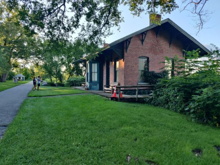
One genre of attempts to twist renewal’s admittedly highly undemocratic processual legacy into preserving its physical legacy is the preservation of open space at the expense of the potential to restore the dense development that in many northeastern cities existed before the era of renewal. One of my favorite hangouts in Albany was Hudson-Jay Park, a small green space carved out of the junction of the dense brownstones of Center Square and the Modernist marble wall of the Empire State Plaza, and a legacy of land cleared for a never-built planned freeway tunnel entrance.

hudson jay

Hudson-Jay Park in Albany, looking east toward the Empire State Plaza. Author’s photo.

Or take the example of Meriden, Connecticut, which I wrote about in 2014. In the core of downtown, right across the street from the railroad station, a giant, autocentric mall had torn down several square blocks of dense urban development decades ago. With the coming initiation of more frequent rail service on the Hartford Line, Meriden engaged in a generally positive community process designed to revitalize downtown with TOD….but instead of restoring dense development on the former mall site, built a giant transit-oriented park.

meriden

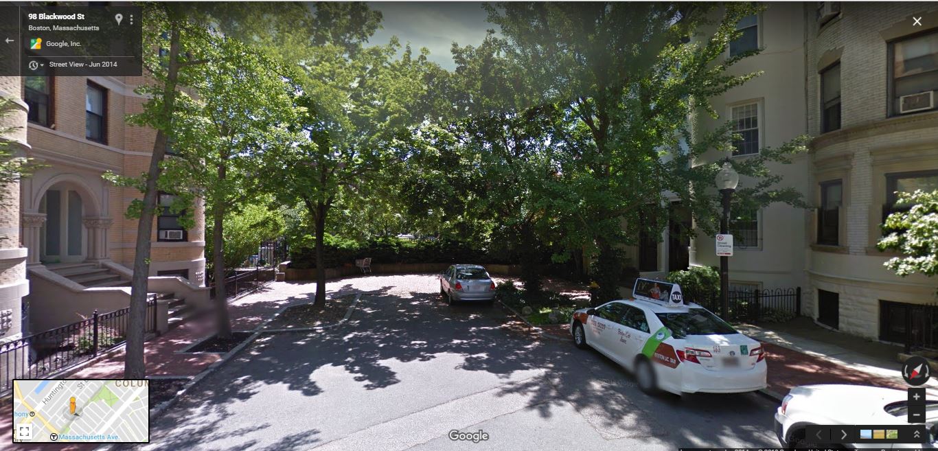
Meriden is, though, an economically depressed city where the demand side of the development equation is unclear and where community members may be less conscious of exactly how they’re handling the legacy of urban renewal, so let’s take a look at an example closer to my current home.  Last year MassDOT sold off a number of small plots of land along the Southwest Corridor in Jamaica Plain (JP). The plots are a direct legacy of the era of urban renewal and freeway construction; the state had seized them decades earlier in order to build a freeway on what’s now, after a civic revolt, the Amtrak/MBTA line known as the Southwest Corridor. Since rail lines, even with an accompanying greenway, take up much less room than a freeway, the state was left with a number of leftover lots, some of them of irregular size or shape, but many of them potentially suited to restoration of the dense pattern of development that existed before the massive use of eminent domain and land clearance in the area. Since the construction of the Southwest Corridor, some of these lots have become open space or part of the greenway; others serve as community gardens. Indeed, one of the lots was taken off the auction block in order to formalize its use as a garden. An anonymous Twitter user took the time to argue with me, contending that my desire to see public land used for a purpose higher than community gardening was, in fact, insensitive to the memory of the struggle against urban renewal:

Similar thoughts appeared elsewhere during the discussion. I think it’s worth diving into that a little bit. In the mind of this Twitterer–and numerous other JPers–fighting urban renewal has nothing to do with restoring the dense development that characterized pre-renewal JP, or fighting autocentricity per se, but relates exclusively to honoring the wishes of the self-defined “community” that once fought renewal–and no one else. Fighting to preserve open space–open space that had not always been that way!–in an area truly rich in it when Boston is suffering from a housing crisis induced in large part by the era of urban renewal seems, in contextual reality, not only quite far from honoring the fight against renewal but indeed supportive of the very ideas that drove renewal in the first place. What better honors the JP that existed before renewal: a community garden or moving toward rebuilding, for example, the vibrant commercial area that once existed around what is now Green Street station on the Orange Line?

Jamaica_Plain_station_postcard_(2)

Jamaica Plain railroad station, on the current site of Green Street MBTA station, around 1910. Note the significant commercial and industrial development around the station. Source: By Unknown – Scanned postcard from eBay auction: “JAMAICA PLAIN MASSACHUSETTS MASS. RAILROAD DEPOT TRAIN STATION VINTAGE POSTCARD”, Public Domain, https://commons.wikimedia.org/w/index.php?curid=45952810

31931813192_72db4a59e6_o (1)

Jamaica Plain station in the middle of disinvestment and urban renewal, in 1951. Source: City of Boston on Flickr. https://www.flickr.com/photos/cityofbostonarchives/31931813192/in/photostream/

green street today

Green Street station today, looking south from the corner of Green and Amory. Note removal of all commercial buildings (although there is one behind the camera) and empty lot at the southeast corner of Green and Amory; I’m told local residents have opposed new construction on this lot.

It’s worth thinking about the implications of an ideology (although it’s hardly theorized enough to be called that, the feeling seems common enough) of open space-as-antidote-to-renewal. I would, bluntly, posit that this ideology is in no way an antidote to renewal and in fact in many ways accepts and cements the Corbusian principles underlying the entire concept of urban renewal. It’s towers in the park, minus the towers, but with some (but not too many) handy restorable brownstones or triple-deckers.

This ideology of garden-as-preservation-from-renewal is, whether consciously in the minds of its proponents or not, inseparable from the same kinds of (mainly white) middle-class consumer desires that actually drove renewal as an ideology. In his highly original and significant The Invention of Brownstone Brooklyn, Suleiman Osman lays out how 1960s South Brooklyn gentrifiers created narratives of saving their “middle ground” (that is, between Manhattan and suburbia) areas from the twin threats of Robert Moses-style Modernist renewal and the uncaring natives who were allowing the area to decline. These narratives, obviously, were self serving, and in them we can see the seeds of some of the more obnoxious aspects of gentrification today. But we see arguably the same logic at play in JP and elsewhere today, as some defend de-densifying the neighborhood and preventing the restoration of transit-oriented development as fighting renewal. Like Osman’s South Brooklyn gentrifiers, the people who fought fiercely for their neighborhood in the face of the assault of Corbusian, autocentric renewal deserve credit for preserving an ideology of urbanism of sorts in decades past–and critique when they end up doing the work of autocentrism.  

Understanding the fetishization of open space in the wake of renewal as a middle-class consumer ideology largely invented by gentrifiers makes the second, and far more challenging, common genre of slightly-off references to urban renewal somewhat jarring. This is the tendency of leftist anti-gentrification activists and some within communities of color to refer to densification and transit-oriented development efforts as a variation on urban renewal. On the one hand, where community consultation is lacking–or even where it is done well, but displacement is accelerating because of strong market demand–it’s reasonable for fearful people to interpret pretty much any action policymakers take as not reflecting the wishes of the community and therefore bringing up the spectre of renewal (and in a situation with limited good options, policymakers should be ready to be accused of not being consultative enough no matter their choices). On the other hand, this accusation completely erases the aspects of urban renewal that had to do with autocentricity and the consumer desires of the white middle class for easy car access throughout the city and easily available parking–which is to say, most of the core of the renewal ideology.

A typical example is this from  Erick Trickey’s reasonably good article on the Green Line light rail project connecting Minneapolis and St. Paul in Politico:

And many poorer communities along the route simply didn’t believe the Green Line would benefit them. They saw light rail as a threat that would disrupt their neighborhoods and bring gentrification—a sequel to the urban-renewal projects of the mid-20th-century that bulldozed poor communities for the sake of suburban commuters…Another reason for opposition—which surprised transit planners and city leaders—was the long memory of St. Paul’s older African-American residents, who’d been victimized by racist highway policy a half-century before. Rondo Avenue, the main business strip in St. Paul’s largest black neighborhood was bulldozed to make way for the I-94 freeway in 1960. That destruction of more than 600 black families’ homes and dozens of black businesses—a tragedy the federal government replicated in black neighborhoods across the country—ripped apart the city’s African-American middle-class economy, inflicting lasting damage to black families’ wealth and homeownership. (A play about Rondo, The Highwaymen, played this February at St. Paul’s History Theatre.) So for some black residents south of University Avenue, another transportation project in their neighborhood felt like war….Nathaniel Khaliq, who was president of the St. Paul NAACP at the time, lost his childhood home on Rondo Avenue to I-94. To avoid any repeat of the disruption the freeway had caused, he preferred an earlier proposal to place the train tracks down the center of I-94. When transit planners chose University Avenue as the route instead, the NAACP sued.

There’s a lot to unpack here. There should be no doubt that community concerns about displacement and racist policy were, as they often are in other cities, valid; while the vulnerability of poor people of color to displacement is a symptom not of transportation policy but of much larger structural forces in American life, it is in many ways felt most acutely in areas with new high-quality transit, given the overall scarcity of such systems in this country. But there’s no escaping the contradiction inherent in the rhetoric and suggestions here. Put simply, the way to protect the black community from a second wave of urban renewal was to replicate the physical planning practices of the original urban renewal programs. Putting rail transit in a freeway right-of-way was for decades, and in some places remains, a common practice, but it’s a really crappy idea that exposes passengers to pollution and minimizes walking access to stations–and cements (literally) the autocentricity of the built environment.

Damien Goodmon of the Crenshaw Subway Coalition provides a somewhat more hyperbolic example of this train of thought in last week’s post in response to Scott Wiener’s ambitious attempt to solve California’s housing crisis by taking the revolutionary step of … building housing.  In response to the idea that dense development should accompany transit, Goodmon declares,

Not since the “Urban Renewal” projects of the 1960s (most appropriately characterized as “Negro removal” by James Baldwin) has something so radical and detrimental to the stability of urban communities of color in California been proposed.

Certainly, Wiener’s bill as proposed would markedly transform many California communities. But Goodmon’s attitude points to a tension in the concept of what’s “good for” disadvantaged communities. It is, in today’s immediate context, somewhat reasonable for communities of color and poorer communities to understand some transit projects and the project of restoring transit-centric urbanity as not being primarily “for” them. In many cities, transit lines generally run radially, connecting outlying neighborhoods to downtowns; as downtown employment has in many cities become increasingly white-collar, low-wage/low-skill employment has fled to the suburbs–often to areas impossible to serve well with transit because of terribly hostile land use. In polycentric Los Angeles, jobs and other trip attractions are spread widely across the metropolis, a development pattern that can be equally hard to serve with transit. Car usage, then, becomes an apparent necessity for low-wage workers, even as it represents a massive financial burden.

However, as I’ve written about New Haven, we should understand this dynamic as being a product only of today’s immediate context, not as inevitable but as a consequence of a series of autocentric policy choices beginning with the era of urban renewal and pushed over the course of decades by the car- and parking-obsessed white and white-collar classes. Thinking of restoring transit-centric development patterns as a follow-on to urban renewal, rather than a refutation of it, only makes sense if one cannot envision a future where disadvantaged people gaine equal access to the world of mobility by transit–a world that should logically be far more hospitable to them than the literally poisonous world of autocentrism. It is possible that if Scott Wiener’s SB 827 were to be enacted as written, it would lead to a traumatic change in specific black and Hispanic communities in LA (though smarter people than I have expressed doubts about that, expecting most new construction to occur on LA’s rich, NIMBY Westside). Yet it is virtually inevitable that in the long run life for the poor and vulnerable in California would be greatly improved by greater housing availability, more transit, and the restoration of the ability to live a life without car ownership, now effectively government-mandated in much of the state.

There’s a lesson there for policymakers, and it doesn’t consist exclusively of “consultative planning is the way to make up for urban renewal.” Rather, it’s that undoing the damage wrought by renewal is a long-term process that we must consistently center on strong principles relating to  mobility, design, safety, and equality. Taking once more  the example of New Haven, which has hollowed out its downtown for parking at the demand of white-collar professionals, only to see increasing numbers of  jobs taken up not by city residents but by suburban commuters. It is those demands for parking, and those worries about the speed of traffic that lead to widening of streets, marginalization of transit, and increasing hostility to pedestrians, that represent the true core of the anti-humane and inegalitarian legacy of urban renewal.

To some extent, I think urban renewal discourse has become so toxic and counterproductive precisely because we find ourselves at a moment of transition and crisis. Urban renewal and freeways destroyed the spatial/economic logic of transportation and land use that had prevailed since the beginning of urbanity, a logic that values physical access and proximity. With the end of construction of new urban freeways (with some horrific exceptions) and growing congestion strangling suburban highways, that logic–one that rewards compactness and punishes spawliness–is reasserting itself rather strongly. It is, perhaps, a testament to the lasting autocentric effects of urban renewal that many people, including advocates from the very communities that have suffered most from renewal, are struggling so hard to adapt to the new/old reality.

Fighting autocentrism remains an uphill battle in the US. As I hope I have made clear here, despite the reassertion of basic spatial logic in recent decades, the principles of autocentricity, car mobility, and easy parking introduced by the era of urban renewal have proven extremely durable and remain in practice remarkably popular, no matter the consensus on Urbanist Twitter. It’s important to keep in mind, then, that those principles ultimately reflect a spatial, economic, and social ethic not of equality and egalitarianism, but of segregation and geographic injustice–an ethic that has done enormous damage to vulnerable communities across 60 years of car-centric American living. The lesson here is, to say the least, not to liberate vulnerable communities, or preserve “authentic” urban neighborhoods like JP, by cementing autocentricity, but to smash the wheel entirely, taking our inspiration from a renewed understanding of the core meaning of renewal–and from aspects of the neighborhoods and networks that existed before it, modified with the lessons we have learned about democracy, privilege, racism, and egalitarianism in the meantime. Onwards.

Ironies of Highest and Best Use

I went to the Roslindale Square/Village RMV to convert my NY license to a MA one yesterday. While I successfully converted the license, the trip was a pain because a) I was available to do it because I was home sick from work and b) the RMV has clearly not learned the lesson I keep tweeting at transit agencies, that inaccurate real-time estimates are worse than none at all (I was given an estimate of zero wait and ended up being there for 45 minutes, standing the whole time in a room that was incredibly hot and smelled strongly of pot and people). It did, however, give me a chance to check out the area some, and in particular (the exterior of) a building I had wanted to see, the former Boston Elevated Railway Company substation at the corner of Washington Street and Cummins Highway.

A substation, you might think, would be a boring and utilitarian building. Not so! Remnants of traction systems past–and there are many, since the power systems (as opposed to the tracks) tended to be heavily built–were in fact often elaborate in design and construction.

wp-1488927803337.jpg

The Roslindale Substation, from Adams Park across the street.

The Roslindale substation features beautiful brick construction and high, arching windows; while it’s clearly a building with an industrial history, it’s the furthest thing from today’s functional but ugly boxes. Most interestingly, perhaps, the substation occupies a place of honor and importance in Roslindale, at the intersection of two busy streets (and transit corridors) and in the absolute center of the neighborhood.

rozzie

On the one hand, this makes sense, since several trolley routes historically converged at this corner, as seen in a 1936 map:

ros square substation 36

On the other hand, it seems like placing a substation–as opposed to, say, storefronts–on such an important corner would have been a terrible violation of the zoning/real estate principle of highest and best use, although it should be said that the substation was built in 1911, before zoning swept America. To a certain extent, surely, the substation’s location was the product of a disconnect between transportation and land use; from their own perspective, it made perfect sense for BERy to place it there in 1911. And for much of the building’s history, demand for land in Roslindale Square was relatively low; it was, after all, vacant for 45 years, until just this year. But–and here’s the irony the title of this piece refers to–the area is now somewhat up-and-coming, and the substation is now in the process of being converted to commercial use (an already-open craft beer store and a restaurant to be called the Third Rail), with the remainder of the lot taken up by new apartments. As the planner’s proverb that I just made up goes, every lot finds its highest and best use, sometimes it just takes 106 years.

Interestingly, much the same story unfolds just a few miles down Washington Street toward downtown Boston, with BERy’s former Egleston Square substation.

Egleston substation walgreens

Like Roslindale Square, Egleston Square historically represented the convergence of several transit lines, and was thus a logical place to put a substation. Unlike the Roslindale substation, this one served both streetcars and the Elevated, and thus remained in service until the closure of the latter in 1987. Like its more southerly counterpart, though, it fell into abandonment and ruin thereafter, until being resuscitated in 2008 to serve as the studios of Boston Neighborhood Network Television. As you can see from the Streetview capture above, the building is a remarkable contrast to the low-slung, suburban-style Walgreens next door–the high-quality architecture of a century ago continuing to pay dividends. While Egleston Square as a whole is not the world’s most urban-feeling built environment, the substation should–after nearly a century of life as an industrial building–be able to help anchor its rebirth in its new role.

If there’s a point to this post, other than that people do interesting things with old trolley substations, it’s that good architecture endures and tends to lend itself to a positive use in the long run. Like life, land-use dynamics are unpredictable and changeable, which is (part of) why locking uses and styles forever, as American zoning slanted toward single-family uses typically does, is a bad idea. Did the architects who designed the Egleston and Roslindale substations in 1909 and 1911 ever imagine the buildings being adaptively reused for another purposes? Unlikely, although they were clearly built to last. This is not to say that every abandoned building can or should be reused, but it’s a useful reminder of the way demand for land can change over the course of a century. And who knows? The Go Boston 2030 transportation plan, released just today, calls for rapid bus lines to pass both substations. Though they’ll most likely never power trolleys again, both substations could again serve an important transit-oriented use (as they do relative to local bus service today), as attractions drawing people to their neighborhoods along the transit corridors of the 21st century.


An Announcement

I’m aware this blog has been too damn quiet lately, and while I know there’s no excuse for my failure to provide quality content, I’m here now to offer, at least, an explanation: I’ve been spending a lot of time applying and interviewing for jobs, most of which have required travel somewhere, well, other than Albany. It’s been a wild ride and while I’ve had both fizzles and opportunities along the way, it’s taken a while to find the right fit.

Anyhow, now that phase is over.

The Itinerant Urbanist (I keep telling you, the name of the blog isn’t for nothing!) is back on the road—and, what a shock, once again to someplace new to me. Effective January 15th, home base for this blog will be Boston, where I’ve accepted a position as a Transportation Planner and Unified Planning Work Program manager with the Central Transportation Planning Staff, the staff to the Boston Region Metropolitan Planning Organization. I’m excited about both the professional challenge ahead of me and the opportunity to move back to a somewhat larger city—while I do wax poetic about the virtues of midsize city living, there are real advantages to being someplace larger.

I’ve had the luck to count on professional and social contacts among Boston’s large and talkative transit/urbanism Internet community, and I look forward to getting to know more of you in real life. You probably won’t see me commenting on Boston-region stuff too much here or on Twitter—because, you know, professionalism—but know I value the perspective on the region you’ve given me and will continue to help me develop immensely. And I will, presumably, get back to writing on other topics in this space more regularly when my life calms down.

A few weeks ago someone asked a series of questions about where people would like to live, among other things, on Twitter and Urbanist Twitter had a lot of fun with it. My answer to the question of my favorite American cities, ironically, did not include Boston:

https://twitter.com/sandypsj/status/805968421112397824

but rest assured that I am super excited to have found a decently priced apartment a two-minute walk from the Orange Line (Green Street in JP, to be exact), which will be the closest I’ve ever lived to rail transit, or any transit that frequent. My partner’s from Boston and I’ve spent a fair amount of time in the area, so in that way it’s a return home of sorts, but there’s enough mystery left that I’m looking forward to discovering yet another place afresh.

That being said, since it became clear that I’m moving to Boston it has felt, in some ways, fated. While home cleaning out my bedroom in Chicago over Thanksgiving, I found a memento that I had not remembered owning—a laminated poster with a 1915 map of the Boston Elevated Railway transit network on one side and a 1912 map of all the street railways in Massachusetts on the other. Bringing it back to Albany reunited it with my copy of this book on a similar topic. The poster will, I think, be going on my cubicle wall. A sign? Perhaps.

wp-1482284672768.jpg

The Boston side of said poster.

There’s also this:

While I have not (yet) traveled all 3,365 miles of U.S. 20, it does feel to a large extent like that road is the axis along which my life unfolds. My grandmother until recently lived only miles from its Pacific Coast terminus in Newport, which is a beautiful little town that I recommend visiting if you ever get the chance. I spent my high school years in Chicago, and the last 3 ½ in Albany; Route 20 runs through both cities. Our Albany apartment, in fact, is a block and a half from Madison Avenue, which hosts 20. So is it such a surprise that I would end up near the East Coast origin of U.S. 20? Perhaps not.

Because this is a serious blog, I’ll wind up here with some serious analysis. There’s been a long-term on-and-off discussion in the econ/planning/urbanist Internet community—starting even before the 2016 election made it a much-talked-about national issue—about what policymakers can do to help rural and disinvested communities and the people in them. It’s not uncommon to hear (and I’ve been guilty of thinking it myself sometimes) “well, why don’t they just move?” And sure, relocation is one potentially workable strategy. But more than anything else, preparations to make this move have brought home to me just how high the barriers can be to relocation in a high-cost area. We’re lucky that in moving from Albany—certainly not the worst off of Upstate’s major cities—to Boston our rent is ONLY approximately doubling, not tripling. And the amount of cash necessary to put down to secure an apartment is incredibly intimidating, even though Gabriella and I are both white-collar professionals with limited student loan debt and decent savings socked away. I don’t have a magical solution (and I might suggest that we shouldn’t necessarily be looking for such silver bullets) but we should have a policy of easy mobility, and we should think about how to make that happen.

SPEAKING OF WHICH, if you care enough about my ramblings to have read this far—my loyal, brilliant, and thoroughly professional partner Gabriella, who I followed to Albany and who is now following me to Boston—is looking for a job. Gabriella’s spent the last several years developing and managing a multimillion-dollar climate resiliency program for farmers in New York State and is open to any kind of environmental work. You know where to find me with suggestions, contacts, etc.

I’ve enjoyed meeting people through this blog for the last several years, and I hope to continue to do so going forward. Thanks for the company, and onwards.

Don’t Talk About the North-South Rail Link without Context

Boston’s North-South Rail Link is in the news again. And while blog readers know I think the project should have been finished a century ago, and anyone who follows me on Twitter knows I’m a big fan of the idea, I’m a little frustrated with the way dialogue about it seems to be going.

The current round of NSRL discussion was set off by former Massachusetts governors Michael Dukakis and William Weld, who penned an op/ed in the Boston Globe arguing against the Baker administration’s plans for expanding North and South Stations and for building NSRL instead. Perhaps Dukakis and Weld are working through some of their own culpability for not getting the project built as part of the Big Dig, as originally planned; regardless, I certainly agree with them that expanding the dead-end terminal stations is utterly foolish and wasteful.

I also, however, agree with some of Gabrielle Gurley’s rejoinder in Commonwealth Magazine, which argues that Dukakis and Weld’s piece failed to factor in the realistic politics of taxation and spending in Massachusetts, or present a realistic plan for building the very expensive tunnel. Gurley’s piece is far from perfect–she lumps NSRL, a project that would massively increase system efficiency, with South Coast Rail, a boondoggle that continues in the T’s long tradition of overengineered, efficiency-sucking outward expansions–but she does have a point that the politics of spending on large infrastructure projects are tricky at best. Boston has had some traumatic experiences with massive infrastructure projects, and the T’s problems with project management are both well-known and ongoing.

Dukakis is nothing if not determined, though, and he wrote back to Commonwealth, arguing the Gurley’s math had failed to take operational savings and new ridership into account:

And third – a point your piece totally misses – because the thousands of new passengers will produce approximately $120 million dollars a year in new passenger revenue and $80 million in maintenance savings. And that doesn’t even factor in the “value added” that will come from private leasing and development along the route, some portion of which can be captured as additional revenue.

Those combined funds will support a 20-year bond issue that can pay for the project. That is why it will be far easier to win public support for the project and why your column today totally misses this key point.

Dukakis’ numbers (he seems to assume a project cost of $4.4 billion) may or may not be accurate; it seems to me that he states them with far too much certainty for a project that hasn’t been extensively studied in at least 10 years. What bothers me is that both he and Gurley treat NSRL as if it’s a a standalone project. It’s not, and it can’t be.

Currently, the entire MBTA commuter network–even the Providence line that runs under Amtrak-owned catenary–runs traditional (for America) commuter rail trains consisting of a diesel locomotive and towed coaches. Diesels won’t work in a long tunnel, for obvious ventilation reasons, so any NSRL will of course be electrified. Some past studies have assumed that the MBTA and Amtrak would switch to using dual-mode locomotives on some or all lines once a tunnel is built, but that’s kind of nuts; while New Jersey Transit uses dual-modes in regular service, they’re heavy, slow to accelerate, and inefficient. Realistically (and desirably in terms of service efficiency, quality, and reliability), large-scale or complete electrification of the MBTA network must accompany NSRL.

And that’s a good thing! Electric trains are faster, quieter, and more reliable. Electrifying the whole network and treating it like a regional rapid transit system would be a huge boost to mobility for the Boston area. But it also adds considerable expense to the NSRL project. Alon ballparked a figure of $1.5 billion for complete electrification in his post on the topic. Amtrak’s New Haven-Boston electrification was contracted at $2.3 million per double-track route-mile, though Paul (and others) think the final number was higher. $3 million per route-mile seems reasonable; you might save some on single-track sections (although the underlying infrastructure is the expensive part), and save in other places. Using the $3m/mile number, and excluding the already-electrified Providence Line (though that line, as F-Line points out, would need upgrades to the electrical infrastructure because of Amtrak’s cheapness), I come up with a number lower than Alon’s, just under $1 billion: (information from here)

Line Route-Miles Cost @ $3 m/route-mile
Newburyport/Rockport 34.9 104.7
Gloucester Branch 16.8 50.4
Haverhill 32.1 96.3
Lowell 24.5 73.5
Wildcat Branch 3 9
Fitchburg 48.8 146.4
Worcester 44.3 132.9
Needham 9.3 27.9
Franklin 27.4 82.2
Stoughton 4.6 13.8
Fairmount 9.2 27.6
Middleboro 35 105
Greenbush 17.3 51.9
Kingston/Plymouth 24.2 72.6
Total 331.4 $994.2

At a minimum, we can say that complete electrification will add $1 billion to the cost of NSRL, and quite likely more. There are ways to reduce that number; most transit pundits think the Needham Branch should be converted to an extension of the Orange Line, and you might not bother electrifying Kingston and Greenbush because of low ridership. On the other hand, Amtrak might want to electrify the all the way to Portland and convert the Downeasters into Regional extensions.

Lest anyone accusing me of scaremongering, I will clarify that electrification of the MBTA system is something that should happen regardless. This is especially true of the South Side network, which persists in the bizarre situation of running aging, slow, unreliable diesels under catenary on the Providence line. It’s about bringing an aging system into the last century. But it needs to be part of the conversation on NSRL–both because of the additional costs and because making the case for NSRL should be only part of making a comprehensive case for modernizing the whole MBTA system. 

Electrification, of course, comes with additional costs. The biggest is rolling stock. By my count, based on Wikipedia, the current MBTA commuter rail fleet has almost 67,000 seats split among 457 or so coaches. Depending on configuration, Metro-North’s M8 EMUs seat about 110 people, meaning you’d need over 600 equivalent units to replicate existing MBTA fleet capacity. At $2.54 million per unit for the initial M8 order, that’s over $1.5 billion to buy EMUs. Things could get a little cheaper; Metro-North is clearance-limited by the Park Avenue Tunnel, whereas MBTA uses a large number of bilevel coaches and NSRL would presumably be built to clear them. The newest (only?) US bilevel EMUs, Metra’s Highliners, cost $3.6 million per unit, and seat 128 (not that great a capacity improvement over single-level coaches, because Metra’s gallery-car setup sucks–MBTA bilevels seat up to 185). MBTA could also choose to buy electric locomotives to haul the existing coach stock.

The final major expense that might accompany NSRL is the cost of building high-level platforms at all, or almost all, MBTA stations. Many already have them; it’s just good practice. Most of the MBTA network sees little or no freight traffic, so clearances really should not be considered an issue. Having level boarding is especially important at outlying stations when all trains are running through a constrained central segment such as a tunnel, and thus must keep to exacting slots. I count 132 stations on MBTA lines that might need high-level platforms; I’m too lazy to look up how many already have them like I did for the Morris & Essex Lines, and how many stations have 1 as opposed to 2 platforms. Cost estimates for high-levels vary; somewhere in the ballpark of $5 million per platform seems reasonable, while MBTA’s fairly simple new Fairmount Line stations cost $6.9-$9.4 million each. If each of the 132 stations costs $5 million for a high-level platform, the total cost would be $660 million; if it’s more like $9.4 as on Fairmount, it would be $1.2 billion. The actual number would likely be somewhere in the middle. 

For the record, Dukakis’ estimate of $4.4 billion in tunnel construction costs seems reasonable if (a HUGE if) the project is managed correctly. Though he and Weld failed to get the tunnel included in the Big Dig, despite it being included in the initial plans at various points, the construction did leave “slurry walls’ underneath the freeway tunnel that make future tunneling easy. The real complication is the need to construct portals for various lines, winding them between many layers of infrastructure. Including my estimates here, the costs of a modernized MBTA rail system would be:

$4.4 billion for the NSRL tunnel

+

$1 billion for electrification

+

$1.5 billion for new rolling stock

+

$900 million (roughly splitting the difference) for high-level platforms

=

a total of $7.8 billion for complete modernization. 

That might be optimistic; one cannot count on the T to manage projects well, and the projected electrification costs may well be low. But it should be fairly comprehensive.

I’ve just spent 1,300 words talking about how expensive it would be to build NSRL and the other improvements it requires. The final number is truly massive, almost twice what Dukakis seems to assume in his recent writing. And yet, I’m doing this as a fan of the NSRL project. Why? Because not acknowledging the true price of the project also risks obscuring its true benefits. Seeking to win over opponents by minimizing the projected cost of NSRL isn’t going to work; Americans are too paranoid about government spending for that.

It’s very easy for skeptics to point to a multibillion dollar price tag and compare the NSRL project to disasters like the Big Dig. But there’s a key difference: the Big Dig represented a choice for path dependence, for continuing Boston’s dependence on highways at massive cost. It was the natural next step for the highway network, representing a relatively minor improvement in functionality–and a major improvement in aesthetics. But it didn’t provide a new function the road network had never provided before. By contrast, NSRL would be revolutionary, not evolutionary. It’s not “just a tunnel,” and if you’re having the discussion on the grounds that it is, you’ve already lost. Proponents of NSRL need to talk about it in terms of its potential to truly transform the entire system, and that means detailing all of the additional functionality that NSRL can provide–and acknowledging its cost.

Notes on Boston-Springfield Service

Readers of this blog know I have a particular interest in intercity rail in New England stemming from growing up in New Haven. So when Eitan Kensky sent me a February presentation I hadn’t previously seen from the Northern New England Intercity Rail Initiative (NNEIRI, not to be confused with the Northern New England Regional Rail Association, or NNEPRA, which runs the Downeaster), I was seriously intrigued. There have been numerous efforts over the years to revive the Inland Regional service that Amtrak and predecessors once ran between Boston, Worcester, Springfield, Hartford, and New Haven, and this document presents the general outline of the group’s current vision for the return of such service. Much of the research seems to have been done by contractors HDR, and the predominant vision is clearly that of MassDOT, with secondary input from Vermont and other stakeholders.

NNEIRI study area map

NNEIRI study area map

Massachusetts has, of late, been focused on two major goals for non-Northeast Corridor intercity rail: a link to Montreal and restoration of Inland Regional service. The current study (logically) links these two together. Tough previous service to Montreal has run along the Central Vermont line, turning off the Boston & Albany at Palmer to serve Amherst before heading north through Vermont, the current vision has Boston-Montreal service using the recently rehabbed Connecticut River Line from Springfield to Greenfield before continuing north. It’s a little bit longer, but serves Springfield, Holyoke, Northampton, and Greenfield instead of just Amherst, and takes advantage of the state-owned Conn River trackage.

The predominant challenge to intercity rail in New England is that the trackage is in most places exceptionally curvy. The build alternatives envisioned for the NNEIRI service thus focused on regular-speed trains, with no ambitious plans for even moderate-speed (110 mph) options. It’s important to remember that “maximum speed” here means Maximum Authorized Speed, or MAS, rather than average speed. On curvy legacy tracks the trains are unlikely to obtain the maximum speeds for very long stretches, given FRA restrictions on tilt for conventional equipment (although the 90 mph MAS alternative does make brief mention of the possibility of acquiring tilt equipment).

Table of service alternatives

Table of service alternatives

A Boston-to-Springfield time of right around 2 hours would be extremely competitive with driving, which is about an hour and a half without traffic (yeah, right) and realistically usually at least a half-hour longer. It’s also about the same time as Peter Pan’s bus offerings, but a train would presumably offer a much higher level of comfort and reliability.

Costs would fall in the billion to billion and a half range for the bottom two alternatives, which seems on the high end for relatively simple double-tracking work within an existing right-of-way; I assume most of the capital expenses would be on the Vermont sections, since the B&A right of way is built to accommodate at least two tracks.

nneiri costs

Overall, the conclusion seems to have been that bumping MAS from 79 to 90 mph would result in considerable extra expense with little time saved or gain in ridership. The study team’s Draft Build Alternative is a modified Alt 2, with 79 mph MAS and slightly fewer trains:

draft build alternative

Eight trains per day would run through from New Haven to Boston, a kind of mini-Inland Regional service. These trains would function as extensions of the current New Haven-Springfield shuttle service. There would be one round-trip per day from Boston to Montreal, and another from New Haven to Montreal, while the Vermonter would continue as it currently operates, with an extension to Montreal. Springfield would get 9 round trips per day to Boston, and presumably the New Haven-Montreal train would have a timed connection with a westbound Boston-New Haven train at Springfield, giving Boston in effect two daily round trips to Montreal.

All trains are envisioned to make all local stops, which is interesting to me; I would have run the Inland Regional/shuttles as expresses in Connecticut, stopping only at Hartford. As it is, the additional 9 corridor trips will provided important added frequency to the NHHS/Hartford Line service that should be beginning in 2016. A 2011 NHHS document envisions full cross-ticketing between NHHS and shuttle/Regional trains, and the boost from NHHS’ 25-32 trains per day at launch to 34-41 including the corridor services is nothing to sniff at. However, that many trains would clearly require Connecticut to finish double-tracking the Hartford Line between Hartford and Springfield. That task isn’t itself all that complex but has been deferred to Phase II of the NHHS project (though it is included in Governor Malloy’s 5-year transportation ramp-up plan) because of the  considerable expense of rehabbing the Union Station viaduct in Hartford–which is, somewhat amazingly, believed to no longer be able to hold two trains at once–and the bridge over the Connecticut River.

Interestingly, study staff clearly believe that Springfield-Boston service alone would be a poor use of resources, labeling it “Low Ridership” and “Ineffective and Costly.” As Alex Marshall pointed out on Twitter, much of the envisioned ridership to New Haven is surely people from Worcester or the Metro West region who want a two-seat ride into New York City without doubling back into Boston to catch an NEC train.

Likewise, the study labeled plain Boston-Montreal service “Low Ridership,” while noting the potential for higher ridership in the New Haven-Montreal corridor. Despite decades of pleading for Montreal service, planners still seem to believe that Boston doesn’t quite deserve it. That’s not particularly surprising to me given how slow such service would be and how sparse population is along the corridors between the two cities. So for now, there will likely be just the one round trip per day, plus the possibility of a two-seat ride via transfer in Springfield, and that situation seems likely to stay the same for quite a while.

Other notes

Finish the Cross

As currently planned, the NNEIRI system looks like a sideways T, with the long axis pointing to Boston. I’m on record as a (self-interested) proponent of Albany-Boston service, and I think some of the improvements proposed here strengthen the case for finishing off a cross-shaped network with trains from Boston to Pittsfield and Albany. Double-tracking the Boston Line from Worcester to Springfield would leave less than 100 miles of single track from Springfield to Albany (it’s 102 track-miles, but there are existing sidings and stretches of multiple track). If trains can do Boston-Springfield in 2 hours, a time of 4 hours to Albany should be eminently achievable even without much in the way of speed improvements. With significant speed improvements (most of the line west of Springfield is limited to 40-50 mph, even though the trackage west of Pittsfield isn’t all that curvy or steep) a time in the 3:30 range–which my previous post identified as the time necessary to be competitive–should be achievable. That would open up the possibility of Boston-Toronto service via the Erie Canal corridor cities–a potential market for an overnight train?

Boston Line Capacity

One of the major ongoing dramas in New England intercity rail has been CSX’ reluctance to share the ex-B&A right-of-way with passenger service. Given current constraints, it is somewhat understandable; it’s a steep, curvy line that has suffered from decades of deferred maintenance (yes, part of that is CSX’ fault, but the neglect predates CSX ownership). CSX runs 25-30 trains per day on the line, which approaches the capacity of a mixed-use single-track line, even one equipped with advanced (by freight rail standards) CTC signaling:

From NCHRP Report 773

From NCHRP Report 773, “Capacity Modeling Guidebook for Shared-Use Passenger and Freight Rail Operations”

Double-tracking the line, however, offers enormous potential, jumping the capacity from an estimated 30 trains per day to 75. In other words, CSX could double current traffic–a situation no one sees as being around the corner in New England–and there would still be 15 slots per day for passenger traffic. More realistically, a fully double-tracked B&A could easily accommodate 40 freights, the 8 proposed Inland Regional trips, 6-8 trips to Albany, and the Lake Shore Limited–a total of under 60 trains per day west of Worcester.  Of course, fully double-tracking the line requires the states of Massachusetts and New York to cooperate, and the Cuomo administration has shown little interest in efficient passenger rail.

Pessimistic SPG-NHV times

The table of travel times above envisions a trip time of 1:40 from Springfield to New Haven given all local stops. This seems somewhat pessimistic to me, as the current shuttles and Vermonter are scheduled for 1:20 to 1:30 over the same route; perhaps the longer time takes into account that a few stops will be added under the NHHS scheme, but those should be counterbalanced by improved track speeds; it’s not a big deal, but I’m somewhat confused.

Who’s going to operate it?

Most commentary I’ve seen has assumed that any extension of rail service from Boston to Springfield would be operated by the MBTA. Running the trains through to New Haven would seem to preclude that possibility. Amtrak would seem the most logical choice, but the northeast state haven’t been thrilled with it of late; Connecticut, for example has opened the NHHS service to a bid competition. The NNEIRI network is an extremely complex system, involving at least three states, plus the province of Quebec and federal authorities regulating border crossings, the private railroads owning the tracks, and various other stakeholders. So perhaps now is the time to revive my call for a unified Northeastern passenger rail authority.


That Time Boston Could Have Had a North-South Rail Link for $8 Million

As part of my research project, I’ve been doing some looking into Boston’s North-South Rail Link concept–the idea of a tunnel linking, finally, North Station and South Station. NSRL is a complicated project whose merits are certainly up for debate (though I tend towards thinking it’s a good idea), but that doesn’t appear to be on the horizon anytime soon. But did you know that there was a point at which Boston could have had the tunnel built at minimal cost to taxpayers?

A March 8th, 1910 headline in the Boston Globe blares :

byrnes

The gist of the accompanying article was that Timothy E. Byrnes, Vice President of the New York, New Haven, and Hartford Railroad, had conveyed to the state’s legislative committee on metropolitan affairs that the New Haven and the Boston & Maine–then united under the ownership of J.P. Morgan protege Charles Mellen–would be perfectly willing to pay most of the costs of a tunnel between Boston’s two stub-end stations, if the city would let them. The catch? They wanted the city to create a “boulevard” between the two stations, presumably cutting a broad swath through downtown Boston to enable cheap cut-and-cover tunneling.  The railroads estimated the costs to the city at $10 million–approximately $240 million today–of which they were offering to cover one-fifth, plus the costs of the tunnel itself, and of electrification of the Boston suburban rail network. Byrnes claimed the tunnel–and accompanying electrification–could be finished within three years, hauling both passengers and freight between northern and southern New England.

Surely, $8 million was a lot of money in 1910. But with the railroads offering to cover 2/3 of the cost of a tunnel, how did a project that would have proved so advantageous to the city that the idea is still being brought up a century later die?

Just four days after Byrnes–who had been on his way out of the hearing chamber at the end of the day when asked to speak–dropped his bombshell on the committee, the city responded. The Globe headline on March 12th read:

city rejects

Babson was the city’s Corporation Counsel, who made sure to tell the committee that “under present conditions the tunnel would not be worth to the city anything like an outlay of $8,000,000” and that “the city should not own the tunnel because it does not own the railroads at each end.” A legislator suggested that the railroads might lease the tunnel from the city, paying 5.5-6% interest and with ownership reverting to the city after 40 years, but neither Babson nor the railroads were amenable to that suggestion.

The tunnel idea did not die immediately–according to one article I have found, it was still kicking around two years later, as part of contentious negotiations between Mellen and the Massachusetts legislature over the fact that his control of both the B&M and the NYNH&H gave him a near-monopoly on rail traffic in New England. The idea of joint government-railroad control of the tunnel, based on a lease with relatively steep interest, had resurfaced, and government investment in the tunnel was on the table in return for Massachusetts allowing Mellen to exercise full control of the B&M (which the legislature had previously intervened to stop). But the Mellen monopoly was, by 1912, in its last days; besieged by legislative action, lawsuits, and public pressure, the New Haven would soon divest itself of the B&M, though not before 21 of its directors (though not Mellen) were indicted for conspiracy to monopoly. I haven’t delved deep enough to know exactly when the tunnel idea last saw the light, but it seems to have died a quiet death.

From a public policy perspective, it’s hard to look back at this episode and resist the impulse to punch a wall. The short-sightedness of the public officials who could have allowed the tunnel to be built–and to high standards, with four tracks and electrification of the Boston suburban network!–is remarkable. But 1910-12 was a very different time in America, a time when railroads were very much still an immediate enemy in public life and a chief target of progressive reformers. And indeed, the 1910 tunnel proposal was very much a product of monopoly–it was integral to Mellen’s vision of a unified NYNH&H and B&M (which, according to the 1912 article, would have been re-branded as “New England Lines”), and the public benefits, while substantial, were entirely secondary. And as quick as we are to condemn brutal transportation-oriented urban renewal in Boston and other cities, can we really look back and say that the idea of clearing a boulevard between North and South Stations was moral?

A later vision of a transportation conduit through downtown Boston. http://www.cyburbia.org/gallery/data/6518/00w.jpg

Land clearance for a later transportation conduit through downtown Boston. http://www.cyburbia.org/gallery/data/6518/00w.jpg

Though we know that constructing the tunnel would have had horrible outcomes for the residents in its way, and it might have strengthened the Mellen monopoly, it’s hard to feel any other way than that Boston’s objection to the project was short-sighted. A full century later, the proposal to build a similar project is still percolating, and it’s hard not to wonder–if there is still an argument to be made for a tunnel, now that the region has sprawled and developed away from the rail-oriented suburban mini-cores that predominated then, how different might the suburban development of the Boston region have looked if city officials had been more willing to work with the railroads 105 years ago?

Ridership and Parking Utilization on the Providence/Stoughton Line

Inspired by a vocal discussion on Twitter last night

Park-and-Rides are one of the most controversial topics in planning and transit circles. Some contend that such facilities encourage unnecessary car use, while others believe that in the right circumstances they can reduce car usage. One example of a notoriously unsuccessful Park-and-Ride facility that came up on Twitter last night is the massive garage at the extreme southern end of MBTA’s Providence/Stoughton line, Wickford Junction, Rhode Island. Opened in 2012 at a cost of $44 million, the station includes a massive, 1100-space garage that is supposedly aesthetically modeled (on the outside, presumably) on the historic Lafayette Mills building nearby. Suburban American kitsch is the best kitsch.

Via RIDOT on Flickr, here’s the garage as completed….

https://www.flickr.com/photos/ridotnews/7024336895/in/photolist-gzomVm-nHRdSt-gzoRik-bGHyBv-btNL87-bGHyCP-bGHyB6-bB1Hmv-fcKxb2-fdfL2F-jpWUCw-bB1HoV-bo6R33-bB1HqH-bQ8mot-bB1uiP-bo6BX7-bo6C1m-bo6BWh-bB1ukc-bQ8nwt-9CYAmB-bQ8qMv-bBdL6S-bQkRiB-bQkRnT-bQkRoD-bBrbNb-bBrbSw-bBrbLw-bBrbFC-bBrbHY-bQkRpa-bBrbEy-bBrbHb-bBdFxm-bBdxKQ-bQ8i4x-bBdC8o-bBdwN5-bBdEhG-8imtV1-bBdyNN-8iif8M-b9Ap7H-jpWUW7-bo6BYA-bo6C2y-bB1unF-bQ8oJX

And under construction in 2011.

https://www.flickr.com/photos/ridotnews/6813671106/in/photolist-gzomVm-nHRdSt-gzoRik-bGHyBv-btNL87-bGHyCP-bGHyB6-bB1Hmv-fcKxb2-fdfL2F-jpWUCw-bB1HoV-bo6R33-bB1HqH-bQ8mot-bB1uiP-bo6BX7-bo6C1m-bo6BWh-bB1ukc-bQ8nwt-9CYAmB-bQ8qMv-bBdL6S-bQkRiB-bQkRnT-bQkRoD-bBrbNb-bBrbSw-bBrbLw-bBrbFC-bBrbHY-bQkRpa-bBrbEy-bBrbHb-bBdFxm-bBdxKQ-bQ8i4x-bBdC8o-bBdwN5-bBdEhG-8imtV1-bBdyNN-8iif8M-b9Ap7H-jpWUW7-bo6BYA-bo6C2y-bB1unF-bQ8oJX

The payoff for all of that investment? A massive, staggering number of riders–a full 159 inbound boardings per day in 2013, as you can see in the handy-dandy ridership map provided by the MBTA in their 2014 Blue Book.

There are few words for the amount of fail that the Wickford Junction project represents. To (perhaps) justify the investment, the station would need to attract nearly seven times the number of boardings it currently sees every day. And that’s to say nothing of the in track, trains, and crew costs that were necessary to extend commuter rail operations that far south in the first place. The overly rosy projections for Wickford Junction ridership date back as far as the 2003 Environmental Impact Study RIDOT conducted for the commuter rail extension, which contains the following helpful predictions:

2003 EIS

2003 EIS

Given the dire situation in Wickford Junction, then, I was intrigued by the situation along the rest of the Providence/Stoughton Line (and by the system as a whole, but hey, let’s start with one line, that’s easier to get a handle on). Here’s a spreadsheet with ridership numbers and parking capacities at all of the stations between Wickford Junction and Hyde Park (I decided it would be silly to look at Forest Hills and Ruggles, where things are complicated by the presence of the Orange Line). Ridership data is from the map above, parking data is from the MBTA website.

Since the sheet doesn’t display well on WordPress, full link is here. In graphic format, the patterns look like this:

Thanks to my partner G for Excel help!

Thanks to my partner G for Excel help!

A few things jump out.

1. The Rhode Island stations south of Providence are obviously a hot mess. If money had to be spent on extending MBTA service down there, the way to do it wasn’t to build fancy stations and then only run a few trains per day. Frequency matters. That should have been obvious from the beginning, but it’s exceptionally clear now.

2. Providence is a nice example of an urban station that doesn’t feel the need to provide huge amounts of parking to attract riders. New Haven could learn a lesson.

3. At the highest-ridership suburban stations on the line (South Attleboro, Attleboro, Mansfield, and Sharon) parking capacity is only about half of boardings, suggesting that many people do indeed walk or get dropped off (these station don’t have much in the way of feeder bus service–Sharon I know for sure has zero).

4. Stoughton and the Canton stations are an interesting case. Parking capacity doesn’t come close to matching the number of boardings–but according to the MBTA’s data, each station has 40% or more of its spaces available on a given day. Stoughton and Canton are relatively walkable despite a dearth of feeder bus service; presumably, many people walk or are dropped off at these stations, and others park for free on town streets to avoid MBTA parking charges.

5. Despite its entirely car-dependent location, Route 128’s parking remains underutilized by several hundred spaces, even taking combined MBTA and Amtrak ridership into account.

Conclusions

A few lessons seem apparent. First, MBTA and the agencies it works with have a problem with overestimation of parking demand–and in that, they’re certainly not alone among American commuter rail operators. Not every lot along the Providence/Stoughton line is underused, but the more monumental ones (Wickford Junction, T.F. Green, Route 128) certainly are. Operators and planners should let the demand for parking come to them, rather than trying to anticipate how it will develop. By all means, reserve space for a garage if necessary, but don’t built it until demand makes itself known. And for god’s sake, tell the locals to charge for parking too, or they’ll take away all of your paying parkers! And remember, even at the best-utilized park-and-ride stations on this line, it certainly appears that around half of riders don’t park to ride the train.

Second (and this may seem obvious, but MBTA and friends don’t seem to have grasped it) the quality of the built environment around the station matters. One of the CityLab articles I linked to at the top argued that distance from the city center should be the determining factor in the decision to build a Park and Ride facility; I’d substitute characteristics of the local built environment. Providence/Stoughton stations that are embedded in relatively walkable areas–Providence, Stoughton, Canton Center, Canton Junction, Hyde Park–exhibit very weak parking demand. Old New England towns don’t exhibit a linear progression from urban to suburban, and planners should pay attention to that. I don’t have much of a problem with Park and Rides in very suburbanized areas, but we shouldn’t be expecting people to drive half a mile from home to the station if they can walk it.