A Walk in the Neighborhood and Urban Albany

It’s drop-dead gorgeous out today, and Wednesday is my day off of classes, so it was time for a walk around the neighborhood. Since the sun is out (finally) I figured now would be a good time to showcase Albany a little bit and comment on some of the (positive and negative) aspects of urban design, planning, and urbanism in the downtown area. All pictures are taken within a mile of my apartment.

Tree budding, Hudson Ave. just east of Lark

Tree budding, Hudson Ave. just east of Lark

One of the the surprising things about Albany is that some of the monumental architecture can make it feel like a much bigger city than it really is (~97,000 people, down from a high of 135,000). Here the towers of the Empire State Plaza–the larger one, the Corning Tower, is 42 stories, and the Agency Buildings are about 20 stories shorter–pop up over the mid-rise apartment buildings occupying the valuable real estate adjacent to Washington Park as we look east down Hudson Avenue. The towers are cleverly tucked into the slope down to the Hudson so that their full height isn’t apparent, but they do put the low-rise Center Square neighborhood into perspective.

wpid-20150429_134900.jpg

Olmstedian (though not designed by Olmsted himself) Washington Park is one of the true joys of living in downtown Albany. Here, the sun shines over the lake that is one of the park’s central features, and over the odd-duck Lake House (now mainly used as a theater), one of a very few Spanish Revival-styled buildings in the area.

wpid-20150429_135424.jpg


Who says modern builders can’t imitate historic styles? I don’t usually walk on the block of Madison between New Scotland and Robin, so while scooting by on the bus I’ve never actually noticed that this townhouse is a relatively recent fake:

wpid-20150429_135638.jpg

Albany has several other infill projects that are well-done imitations of historic styles; it’s something that the city does well. If that offers hope, turning the corner offers despair:

wpid-20150429_135926.jpg

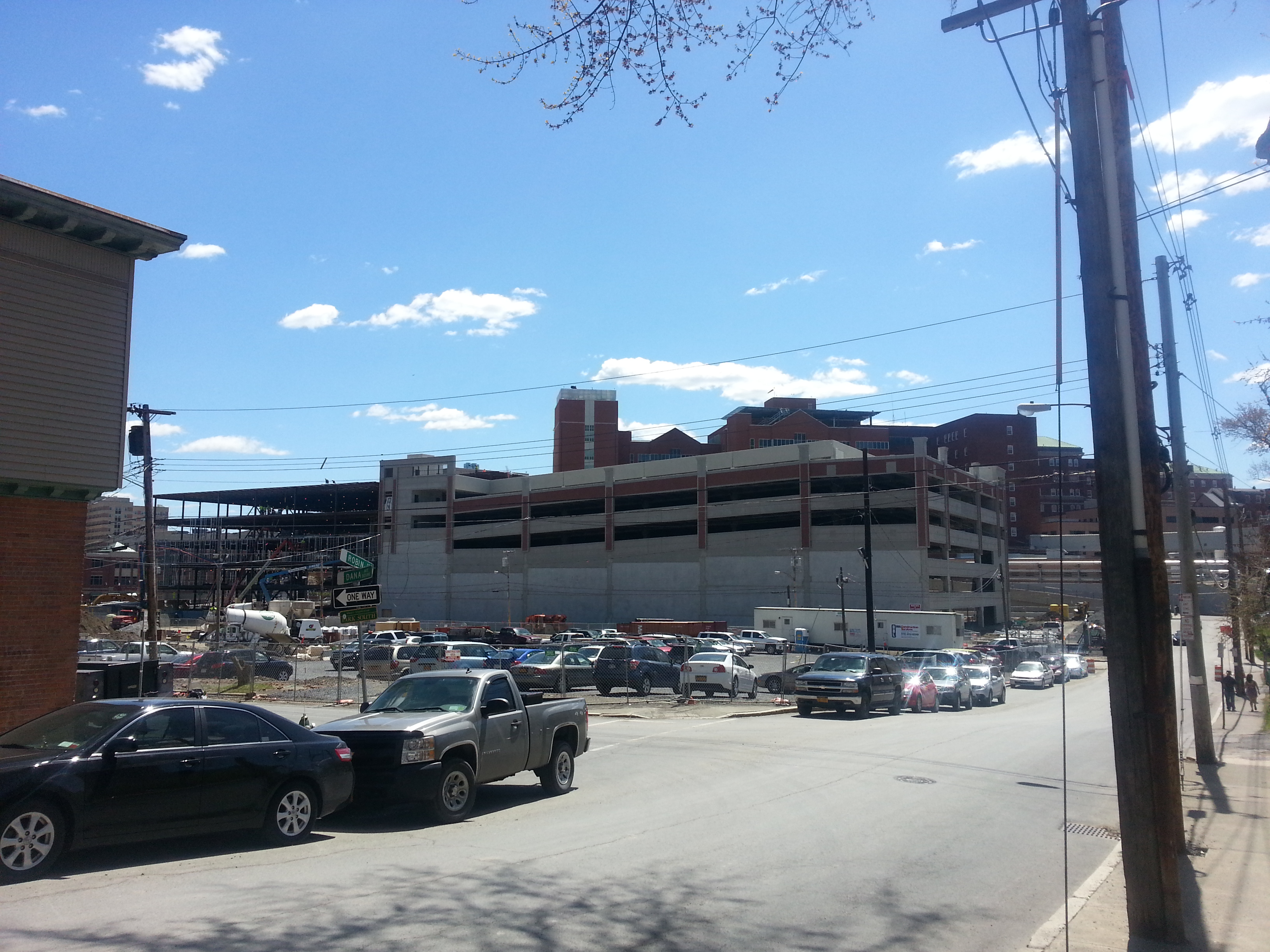
This was really the point of my walk today. The Park South Urban Renewal Plan–yes, we still use that phrase here in Albany–driven by Albany Medical Center has (just since I moved here less than two years ago!) wiped out two whole blocks of homes to put up a new mixed-use development (but mainly just parking). Just months ago, this view would have looked like this:

robin dana

The plans certainly aren’t the worst, but they’re certainly not the most urban-feeling plans either. What makes the project–the beneficiary of state tax credits–particularly outrageous is that the enormous, 800-1000 car garage (the exact size seems to keep changing) you can see under construction in the picture above is completely unnecessary.

More garage, in case you weren't convinced enough of the scale.

More garage, in case you weren’t convinced enough of the scale.

Somehow, a single daffodil survives between concrete, construction materials, and insulation material that's been left out. It's almost TOO #$@#$ poetic.

Somehow, a single daffodil survives between concrete, construction materials, and insulation material that’s been left out. It’s almost TOO #$@#$ poetic.


No seriously, it's really huge.

No seriously, it’s really huge.

What was here before clearance? Nothing particularly special, a few low-rise middle-class homes:

Looking west on Dana about halfway between New Scotland and Robin

Looking west on Dana about halfway between New Scotland and Robin

The Park South neighborhood has been in a rut for a while; many of the houses, including the ones that have survived the renewal project, are in poor shape, and this was never an upper-class neighborhood to begin with. That being said, AMC owns much of the real estate in the area and has been patiently awaiting its opportunity at redevelopment. And major institutions, for-profit or not, that hold on to large swaths of land for a promise of future development over long periods of time are virtually never good stewards; if you haven’t read my early post on Chicago’s The Valley neighborhood, go do so. Granted, it’s an extreme example, but it’s illustrative of the dangers of long-term planning for megablock development.

We’ll close the tour with a picture of something more hopeful, a new mixed-use building (retail on the first floor and apartments above) on the corner of Lark, Delaware, and Madison.

wpid-20150429_141420.jpg

I could’ve gone with two or three more stories of apartments on top, but it’s certainly nothing to sniff at…and there’s no added parking! (the building will share with the condoized historic police station next door on Madison)

Amazing how many issues come up on a brief (1.5 miles total) stroll around the neighborhood sometimes.

Revisiting State-Level TOD Planning

Last month I wrote about Connecticut Governor Dannel Malloy’s ambitious plans to create a state-wide Transit-Oriented Development corporation, essentially making the case that Nutmeggers and planners alike should give the idea a chance. In short, I wrote (and believe) that the state needs some control over station areas to maximize the relatively significant investments it has been making in transit and combat rent-seeking by suburban NIMBYs. That being said, I think the discussion is worth revisiting and sharpening, since this legislation is potentially a really big deal both for Connecticut and the planning world.

The Connecticut proposal brings up two related issues: the question of regional governance and the question of whether state government is any more trustworthy than local government when it comes to progressive principles of planning and development. Let’s tackle these individually.

Regional Governance–Does it Matter?

Angie Schmitt posted a summary of my piece on Streetsblog.net, and it provoked a number of responses, mainly along the lines of “but state governments suck too!” Fair enough–we’ll talk about that below. One commenter wrote that

I have a feeling that Streetsblog is very, extremely casuistic when discussing the “whose level of government should do what”, without any consistency on the arguments, only some specific situation where it will support whatever arrangement works for a single case, damned be unintended consequences.

To which I say: so be it! If I have one feeling about forms and structures of governance, it’s that we don’t matter nearly as much as we think. I’ve been taking a course on regional governance this semester, and while it is perhaps the bias of my professor, the overwhelming takeaway has been that the exact structure of governance and government matters less than accountability, good stewardship, and the intentions of elected officials. This point gets hammered home over and over again in one of the primary books for the course, David K. Hamilton’s comprehensive 2014 Governing Metropolitan Areas: Growth and Change in a Networked Age.  As LetsGoLA wrote in one of my favorite-ever urbanist blog posts,

None of this really matters, though, if the people running the agencies are acting in bad faith…In fact, in the context of discrimination, regional consolidation can make things worse, even if it makes technical sense. For years, urbanists bemoaned the lack of a regional transit agency in Detroit. The feds finally forced the issue, and in late 2012, the state created such an agency. The Southeast Michigan Council of Governments (SEMCOG) was charged with administration during the transition, and promptly used its power to reduce Detroit’s transit funding by 22%. When the problem is a desire to avoid treating some people fairly, technical solutions are helpless.There are no apolitical technical policies.

So yeah, let’s embrace casuistic governance. Whatever works, we can do. After all, casuistic policymaking is as old as the Western tradition; Hammurabi’s Code is largely written in a casuistic mode, as are many biblical legal passages. I don’t really care who runs things, as long as stuff gets done. And conversely, no structure of governance should be afforded less skepticism or held less accountable than any other.

Can (and should) we trust Connecticut state government to be better at TOD than cities?

Anstress Farwell of the New Haven Urban Design League was kind of enough to have coffee with me last time I was in New Haven, and we took the opportunity to chat about the governor’s TOD plans. Anstress, who is inarguably New Haven’s top urbanist scold and city purist, is appropriately suspicious of the ability of any level of government to implement progressive planning principals. It’s an entirely understandable attitude in New Haven, the city that probably did more per capita (it took more federal dollars than any other city per capita) than any other to destroy itself through “progressive” urban renewal.

And it’s completely reasonable to be suspicious of the intentions of state government, considering that it’s pushing giant new garages next to the train stations in both Stamford and New Haven. And yet, in other places, state government has pushed TOD against the NIMBYish intentions of suburban towns, and the state could hardly make existing conditions worse in many places, and seems likely to force some reluctant municipalities into compliance. It’s also worth noting that local government has been on board with the new garages in both Stamford and New Haven, while New Haven is making only halting strides towards tackling its downtown parking addiction.

So can urbanists and progressive planners trust Connecticut state government to implement good policy, should it gain power over station-area land use? There certainly seems to be reason for skepticism. But it also seems unlikely that the state government could do any worse than municipalities are currently doing, and centralizing planning might at least streamline some processes. So I guess the answer is a resounding maybe.

If we can’t trust anybody, what should we do?

One of the ideas that Anstress and I threw around when we chatted was the idea that instead of TOD power resting with any particular level of government, it should instead reside in the area of policy. That is to say, the state should establish a strict set of benchmarks for land use around stations, and give local governments a certain amount of time to meet them. Should municipalities prove unable to meet those benchmarks, the state would then be authorized to seize the land through eminent domain (which it of course already legally is) and add it to the inventory of a statewide TOD authority. This way, it would be the TOD benchmarks–rather than the state authority–that would become the center of the policy. It would be clear that the intention is to achieve good land use, rather than just to concentrate power in the hands of state government at the expense of municipal government. And the targets for municipalities to  meet would be clear and public, meaning the reason for a state takeover would be clear if that should in fact happen.

Obviously, suburban municipalities in Connecticut are going to resist any initiative that threatens to bring them dense development. And city governments clearly need some work as well There is, therefore, an obvious role for state government to play; but what should it look like? In my ideal world, the state would be foregrounding good policy rather than centralization of power in its messaging and actions on the topic, which would likely help them sell the TOD authority as well. Cynical political bartering will most likely win out, but I can dream, can I not?

Notes on Long Transit and Diagonal Streets

Between school, Passover, and life, I’ve been extremely short on time and (especially) focus to write recently (though I did do a Twitter series about Amtrak reform, Storified here), but I do want to get something up.

Jake Blumgart has a post in the Philly Voice about SEPTA’s fabled Route 23,  the former-trolley-now-bus that connects tony Chestnut Hill in the city’s Northwest with Center City and South Philadelphia. Route 23 has been acclaimed as the world’s longest trolley route, a claim I’m skeptical of, if only because Chicago’s Route 49 (Western Ave.) has run up to 20 miles at times. It’s also a flashpoint of the bus-trolley wars, with some romantics consistently calling for the return of the trolleys that were taken off the route in 1992 (much of the rail infrastructure remains in place). The problem is that, as Blumgart notes in his piece, “When trolleys rumbled along the 23, an end-to-end ride took more than three hours; the bus takes about half of that time.” (I believe that number is somewhat exaggerated–Blumgart got it from long-time riders of the route–but there’s little doubt that the trolleys were indeed slower than buses that can pull into and out of traffic)

Route 23 intrigues me because it combines two particular challenges of urban transportation planning: super-long mixed-traffic transit routes and diagonal streets that cut across the city grid.

Route 23 map from SEPTA's schedule packet--so long it needed to be split into two images!

Route 23 map from SEPTA’s schedule packet–so long it needed to be split into two images!

As you can see from the map, Route 23 runs largely in a two-way pairing on 11th and 12th Streets from its terminus in South Philadelphia through Center City, then switches onto the diagonal Germantown Avenue, running northwest to the tony Chestnut Hill neighborhood. The route is also very long for a local bus, almost 14 miles. As a result of the length and Philly’s notoriously narrow and congested streets, Route 23’s on-time performance in 2012 was only 64%, fairly atrocious by transit standards. As a result, SEPTA is considering splitting the historic route in two, with one branch running from Center City to Chestnut Hill and the other from Center City south. Since–as Blumgart documents–virtually no riders use the whole route, there seems to be little opposition to this change.

And that leads me to thinking about the viability of super-long local bus routes in other places. I used to commute on the Chicago Transit Authority’s #49 bus, the core service on Chicago’s uber-long (24ish miles) Western Avenue. Where Route 23 is scheduled to cover its 13.8 miles in about 1:15, for an average speed of roughly 11 mph, CTA’s 49 is even slower, scheduled to cover its 15.7 or so miles in 1:30, for an average speed just under 10.5 mph. Aside: this means that the CTA 49–which has, in the past, extended past its current terminal at Berwyn all the way to the Evanston Line, about 3 more miles–is both longer and slower than the much-maligned Route 23. Unsurprisingly, the 49 is a massively unreliable route, with bunching common. Since the cancellation of the former X49 limited a few years ago, it is the only transit option in the corridor, and one of the most popular routes in the city, carrying even more people than the 23.

The problem with the 49 is that, unlike the 23, there is no especially convenient place to split the route in the middle. I’m sure relatively few people ride the route from end to end, but there’s no point where the entire bus empties out and exits, as happens to the 23 in Center City. Additionally, I will personally testify that having more splits in the route would be a massive pain in the ass, since having to transfer from the 49A and 49B extensions to the core route in order to continue a linear journey is already a major problem. The 49’s reliability problems can’t be dealt with by cutting the route in half, so what options are left for the CTA and other operators faced with similar long-route challenges? (that’s a genuine question!)

The other thing that’s intriguing about Route 23, of course, is that its northern half runs along Germantown Avenue, a diagonal street that once connected that neighborhood to the Philly waterfront. Though Philly’s grid isn’t as regular as, say, Chicago’s, Germantown Ave. still stands out as an oddity on its generally northwest-southeast path.

Germantown Ave. highlighted, from Google Maps

Germantown Ave. highlighted, from Google Maps

Germantown Ave.’s odd alignment–and its Phillyish narrowness–makes it a challenge for fast, efficient transit–but an opportunity for other things, as James Kennedy of Transport Providence, a Philly native, pointed out:

https://twitter.com/TransportPVD/status/590903506439122944

https://twitter.com/TransportPVD/status/590904084925931520

https://twitter.com/TransportPVD/status/590910894193913856

This is a question that intrigues me, since Chicago’s notorious diagonal streets have proven to be a major challenge for traffic of all types in that city. Of course, Chicago’s diagonals are more regular, such that they often cross two other arterials in a nightmarish six-way intersection. Witness Lincoln, Damen, and Irving Park:

Or Lincoln, Ashland, and Belmont:

Among other terribleness, the new Google Maps is temperamental about embedding, so you get a JPEG for this one.

Among other terribleness, the new Google Maps is temperamental about embedding, so you get a JPEG for this one.

These intersections are horrible for pedestrians, create massive traffic jams, and just generally suck. And there’s not too much the city can do about them. The problems at the intersection of Damen, Fullerton, and Elston are so bad that the city is spending millions to realign the intersection, but low-value industrial land isn’t usually available to do that.

Chicago DOT's graphic explanation of the Damen-Elston-Fullerton realignment.

Chicago DOT’s graphic explanation of the Damen-Elston-Fullerton realignment.

Perhaps the boldest initiative Chicago has ever undertaken to tame one of its diagonals was the 1978 pedestrianization of a short stretch of Lincoln Avenue (no, not all of the horrible intersections involve Lincoln, but it does have many of them) southwest of the intersection with Lawrence and Western, creating the Lincoln Square (mostly) pedestrian mall, the core of one of the city’s hottest real estate markets:

western lawrence

Perhaps the Lincoln Square mall has been buoyed (and to tell the truth, it hasn’t exactly been a smashing success) by being next to the busy Western Brown Line station. But it might also represent the potential of a new approach to those problematic diagonal streets. The luxury of a grid is that it often works best without diagonal streets cutting through it at angles that are either random (Germantown) or too regular (most of Chicago’s diagonals). Surely, the idea of making these streets into a transit, bike, and pedestrian mall is radical. But it may be a really good idea.