Why Connecticut’s TOD “Power Grab” is a Big Deal

CT News Junkie reports that the Connecticut legislature is considering a pair of bills that would to some extent transform the paths of governance in the state. Writer Suzanne Bates frames the bills as a centralization of power in the hands of the state, which is a conclusion that’s hard to argue with, though I imagine many of my readers will not consider that a bad thing as she clearly does. The first bill concerns a couple of changes to the way the state administers taxes, but it’s the second one that we’re more concerned with here:

The second bill — House Bill 6851 — is also a power grab by state government. It would give a quasi-public state agency — called the Transit Corridor Development Authority (TCDA) — control over housing and commercial development around transit stops….

The bill has changed significantly since it was first introduced — for the better. Initially, the TCDA would have had the power to use eminent domain to condemn property around planned or current transit sites. As amended, the bill keeps eminent domain authority with municipal and state lawmakers.

The bill also no longer has the language that municipal governments “will” comply with the TCDA. Now local authorities would delineate the land designated for transit-oriented development, then enter into an agreement with the TCDA to turn that property over.

Bates considers the bill a threat to local communities and Connecticut’s tradition of home rule. I want to offer a different perspective that might explain why Governor Malloy and his supporters in the Legislature might be willing to consider what seems to be a drastic step.

Transit-oriented development, or TOD, is a central pillar in Governor Malloy’s statewide transportation plan. And there have certainly been successes; the new CTFastrak busway, connecting Hartford and New Britain, has spurred redevelopment along its route, and the governor’s office has made funds available to further TOD efforts in that corridor and along the soon-to-open New Haven-Hartford-Springfield (NHHS) rail line. Malloy has not just pushed the state’s significant (and expensive) transit projects, but has put considerable capital, both political and fiscal, behind the state’s efforts to build TOD around the new or revamped stations.

The problem is that Connecticut’s municipalities have not always been amenable to the state’s TOD strategy. A 2013 Regional Plan Association Report entitled “Halfway There” revealed that of the stations along the Metro-North New Haven Line, the state’s busiest transit corridor, only around half had (realized or envisioned) plans for mixed-use walkable development in the station area.

From RPA report "Halfway There," http://library.rpa.org/pdf/RPA-Halfway-There.pdf

From RPA report “Halfway There,” http://library.rpa.org/pdf/RPA-Halfway-There.pdf

Last year I wrote about how Meriden, whose Amtrak station will be upgraded for the NHHS service, is wasting the potential for true TOD in its downtown, planning to use a huge lot across the street from the station for a park rather than dense development. Newington, along the CTFastrak corridor, has (over the objections of its well-meaning economic development chief) considered implementing a moratorium on high-density development. Taken together, these developments–or really, lack thereof–reveal an ongoing threat to Governor Malloy’s transit- and TOD-centered agenda: the ability of individual municipalities to sabotage the state’s efforts through uncooperativeness or obstinacy.

Quite simply, the ability of Connecticut’s municipalities to prevent TOD not only undermines principals of progressive development but threatens the the viability of the state’s expensive transit investments themselves. It’s a pattern that has played out repeatedly across the country: some higher level of government, be it federal, state, or regional, invests significant money and energy in building a new transit system, only to see the municipalities along the line reserve the benefits of the investment for existing residents of the area. The rhetoric may be about local control and “the character of the area,” but the realities of the movement are all too often more cynical. Pocketing the benefits of state investments in mobility while denying them to other people who may wish to relocate to the area and refusing to allow growth that will enhance the state’s investment is not only regressive; it is the kind of rent-seeking that has handicapped transit planning all across the country for years. Connecticut must do better, or its aggressive transportation investment program will largely go to waste.

A CTFastrak bus demonstrates the state-municipality disconnect as it approaches the not-yet-complete station at Asylum Street and Union Place in Hartford, 3/29/15. The buses and busway are a state investment; the not-ready-for-opening-day downtown stations are the responsibility of the City of Hartford.

A CTFastrak bus demonstrates the state-municipality disconnect as it approaches the not-yet-complete station at Asylum Street and Union Place in Hartford, 3/29/15. The buses and busway are a state investment; the not-ready-for-opening-day downtown stations are the responsibility of the City of Hartford.

Is the bill that the Malloy administration is currently pushing the right way to correct this imbalance? In truth, the bill, especially in its watered-down form, won’t make the state’s powers that much greater, since it already holds power of eminent domain. The bill would seem to exempt state-owned properties from local zoning–a major step–and would centralize parking rates in the station area in state hands, which is a no-brainer. It would also create a central administration for station areas, which could be good or bad, depending on the leadership and competence of that authority. I wonder, though, if there is a middle way forward where municipalities that are willing to voluntarily follow the principles of TOD could maintain local control so long as they meet a checklist of requirements that would allow the state to maximize its investment. I’m sure many of the larger cities would be thrilled to work with the state on that approach. It’s also worth noting that state priorities aren’t always the most progressive; the state has recently agreed to fund a second massive parking garage for New Haven’s Union Station.

In the meantime, though, the Malloy-backed idea of centralizing land-use authority in station areas might represent a way forward for numerous transit systems across the country. Imagine if instead of building transit and just hoping the local municipality will do the right thing, states and authorities could go about their infrastructure business secure in the knowledge that land use will support, not sabotage, ridership potential. Stephen Smith made the argument on Friday in New York YIMBY that “Community Control is Destroying America’s Cities,” and while he may overstate the case to some extent, similar dynamics have too often played out around new transit investments. Let’s give Dannel Malloy’s efforts at state-driven TOD a shot. After all, it may be a power grab, but it’s not about abusing authority; it’s about protecting an investment from those who would waste it. That’s a principle citizens of any ideological stripe can get behind.


The Second and Third Lives of Elite Urban Neighborhoods

Gentrification, of course, is all over the news. We hear about it all the time. We’ve also heard a lot about how poverty is a bigger problem for most American cities than gentrification. This latter point is undoubtedly true. But based on my experience living in and studying a couple of midsize American cities, I want to propose a middle ground–that what might otherwise be called “gentrification” in higher-demand markets in fact follows a somewhat different pattern in these cities.

Last week a friend sent me a link to this interesting documentary produced by Albany’s PBS station, WMHT. Though only aired recently, the footage chronicles changes that took place on the block of Lancaster Street between Dove and Swan (“Lower Lancaster” in the film’s parlance) almost 35 years ago, in 1980-81, as filmed by a cameraman who lived on the block.  The Empire State Plaza—the massive, anti-urban state office campus imposed on Albany by Nelson Rockefeller—had opened at the bottom of the block only a decade before, and its arrival had brought a wave of professional-class urban pioneers (as they repeatedly call themselves) into what had been a somewhat rundown area. The word “gentrification” gets thrown around a lot in the documentary footage, and there’s a lot of talk about the numerous lower-income tenants on the block who were then in the process of being displaced by newcomers who bought up buildings, renovated them, and rented them back out at higher price points.

But is what we see in the WMHT film really what we today call “gentrification”? Clearly, the process in action on Lower Lancaster in the film involves displacement of poorer renters—some, though by no means all in this case, minorities—by wealthier (though not by any means elite), whiter new residents who mainly own their own homes.  But it’s also worth considering the differences between the occurrences on Lower Lancaster and the typical American narrative about gentrification.

The first thing to understand is the Center Square—a name acquired by the area relatively recently, in the postwar era—has long been one of the “elite” residential neighborhoods in Albany. The block of Lancaster in question is only two blocks from Washington Park, around which clustered the toniest homes in Albany (a truly spectacular architectural legacy to this day).  The “Lower Lancaster” block itself is home to a number of gorgeous 2-3 story rowhouses, as well as the 1885 Romanesque masterpiece Wilborn Temple (built as Temple Beth Emeth), which in its day attracted the wealthiest of Albany’s German-Jewish population to the block.  All that is to say that while the area around Lark Street had gone somewhat downhill by the 1930s, with many buildings being converted to downscale rooming houses, it still retained vestiges of its elite past, both socially and architecturally.

Beautifully restored woodwork on the door of a home on Lancaster Street. Lower of two plaques at left is a federal historic designation.

Beautifully restored woodwork on the door of a home on Lancaster Street. Lower of two plaques at left is a federal historic designation.

And it was that heritage more than anything else that made the neighborhood ripe for “settlement” by professional-class types in the years after the South Mall (the original working name for the Empire State Plaza) opened. These people were attracted not solely by the proximity to the Plaza—indeed, many of them were, and continue to be, turned off by its looming presence—but by the neighborhood’s rich cultural heritage and incredible housing stock.

The Empire State Plaza looms at the bottom of the "Lower Lancaster" block.

The Empire State Plaza looms at the bottom of the “Lower Lancaster” block.

The construction of the South Mall may have depressed housing prices in the next-door blocks enough to make the risk of urban pioneering worth it, but people moved into the neighborhood because they saw a potential for its return to, if not quite the same blue-blood elite status, something similar. Many of the new homeowners and urban pioneers would form the nucleus of the neighborhood associations and activist groups that were able to stop the state’s plans for an amazingly destructive freeway through the heart of the neighborhood.

The story of Center Square—and of that block on Lancaster—isn’t a story of a working-class neighborhood ripped apart and transformed by rapacious, profit-driven developers and wealthy outsiders. It’s the story of a neighborhood that, for better or for worse, experienced an abnormal decline in status—helped along, as in many other places, by the government’s intentional, artificial depression of urban land values—in the immediate prewar and postwar decades, and that many people labored to return to something approaching its peak status in the 1970s and ‘80s. In Center Square, it was the use of luxury housing stock by the poor, not its reclamation by the middle class, that represented an exception to the historical rule.

There was, of course, incredible loss experienced in the process of gentrification.  The WMHT documentary makes clear the fear of lower-income residents unsure of their next move. And the documentary preserves some truly cringeworthy moments from the gentrifiers, who proudly proclaim themselves “urban pioneers” (like the “pioneers” of the West, they were, of course, moving into land that was already occupied) and tell soon-to-be evicted residents that “it’s not up to me” and “it’s just economics.” Perhaps 30 years of exposure has taught gentrifying developers to be a little more careful around cameras, but the words here can be quite the jarring reminder of the callousness shown by many early gentrifiers.

Nor, I believe, is Center Square’s experience of gentrification as renaissance rather than transformation unique. Indeed, I believe it might be better labeled part of a pattern of similar occurrences in smaller American cities. Certainly the two other neighborhoods in Albany that might be identified as “gentrified” in recent decades—Ten Broeck Triangle and the Mansion District—fit the same general pattern of being once-elite neighborhoods marked by outstanding housing stock. Neither neighborhood has been as thoroughly gentrified as Center Square, though neither (especially the Mansion District, despite its name) was as thoroughly identified with Albany’s upper crust as the area near Washington Park. Indeed, it is possible that the difference between the “gentrification” of Ten Broeck Triangle and the definite non-gentrification of neighboring Arbor Hill (despite the APA’s best efforts) is largely attributable to historic perceptions that Ten Broeck was the wealthier, more outstanding area.

Since New Haven—a city of mostly similar size, age, and composition–seems to be my most frequent muse for comparisons to Albany, let’s see if the pattern holds there as well. The truth is that for the most part New Haven’s neighborhoods have stayed fairly consistent in their demographic makeup since the disastrous postwar and urban-renewal era.

I’d say that if two New Haven neighborhoods can be identified as “gentrified” they would be the downtown-adjacent (as are Center Square, Ten Broeck Triangle, and the Mansion District) East Rock and Wooster Square. East Rock has always been one of the elite parts of the cities, long home to Yale professors; it is now a “grad ghetto” with a distinctly yuppie feel and a tight rental market by the standards of midsize cities. Like the rest of New Haven, East Rock had its struggles during the postwar era, but it never quite hit the depths of the Albany neighborhoods.

Wooster Square might be a more interesting case.  Originally adjacent to the city’s bustling docks (and since cut off from the water by land reclamation and a massive freeway interchange), it had a short run as a haven for the city’s rich merchants, which gave it an architectural legacy somewhat comparable to those of the Albany neighborhoods. Though some wealthier families continued to live in the area, it always had a mixed class makeup, and fairly quickly became associated with New Haven’s famous Italian community and their distinctive style of pizza. Thus Wooster Square’s primary identification in the minds of New Haveners is as a working-class Italian enclave, but it still holds the architectural and perhaps cultural legacy of its earlier upper-crust residents. Regardless, Wooster Square has seen considerable new apartment construction in recent years, with units being listed for relatively high prices—definitely what the typical American narrative would label “gentrification.”

Diagram of high-status neighborhoods in New Haven in 1909, from Douglas Rae's "City". East Rock at top; Dwight at left. Wooster Square had already declined.

Diagram of high-status neighborhoods in New Haven in 1913, from Douglas Rae’s City. East Rock at top; Dwight at left. Wooster Square had already declined.

Neither East Rock nor Wooster Square follows the pattern I laid out as neatly as do the “gentrified” neighborhoods of Albany, but they’re not that far off. The fate of the Dwight neighborhood directly west of Yale University will be a fascinating test case; formerly one of New Haven’s wealthier neighborhoods, it experienced a redlining-induced slide in the postwar years from which it has never really recovered. Dwight is showing a few signs of gentrification, sparking considerable fear among residents, but whether that process will take off has yet to be determined.

What does it mean, then, that many of the cases of “gentrification” in midsize cities are in fact less a transformation of a neighborhood into something it’s never been than a revival of its former identity? I think it helps clarify a point I’ve had trouble putting into concise words for a long time, but that others have certainly talked about: American discourse—especially on the Left–has been using the word “gentrification” to talk about at least two separate, though related, processes.

Process 1 is the pattern where ridiculously high demand for housing—mainly experienced in larger cities—pushes wealthier, whiter professionals into areas that have always, or virtually always, been lower-middle or working-class. The names of such cases, I’m sure, are familiar to anyone who follows urban issues: Harlem, Bed-Stuy, Red Hook, The Mission, Somerville, Humboldt Park, Boyle Heights. These cases are indicative of a housing market that is way out of whack; certainly, the desires of hipster gentrifiers for gritty “authenticity” play a part, but for the most part these neighborhoods boast neither the best convenience (Red Hook doesn’t have a subway stop!) nor the most outstanding housing stock. The impetus for gentrification is push, not pull.

Process 2 is what I’ve described here as being more typical of “gentrification” in smaller cities, though it certainly describes the recent changes in many neighborhoods in larger cities as well.  In this paradigm, people who we call gentrifiers are pulled to neighborhoods that have lost some of their former considerable luster. Let’s face it: generally speaking, the wealthy of the 19th century chose well. These neighborhoods have a lot to recommend them: they tend to be conveniently located and sport excellent access to downtown, green space, and other amenities. Then, of course, there is the matter of housing stock, which is solid at worst and truly outstanding in the case of the Albany neighborhoods I have highlighted.

We need different words to talk about these two processes.

They share many challenges that urban policymakers have to deal with—displacement of lower-income residents being the primary one—but I would argue that we can distinguish between on the grounds of desirability of their occurrence. Process 1 is a sign of a sick city (albeit one sick with success, or as Jane Jacobs said, oversuccess), and in particular of a sick housing market. It’s a symptom of inequality, bad policy, and all that entails. Process 2 is, despite the displacement and inarguable loss and pain that occurs, most likely a sign of a city that is healing itself. The days of the postwar federal gravy train are over, and cities cannot continue to exist as forced repositories of the unlucky, discriminated-against, or undesirable. Like it or not, cities need a base of upper middle class residents, even a small one, and they have to live somewhere. 

To some extent, the confusion in the term “gentrification” is inherent. Ruth Glass’ original definition of the term made reference only to how a neighborhood that was undergoing the process looked now, not its historic characteristics. When the term migrated across the Atlantic, it was quickly applied to areas like Philadelphia’s Society Hill: once-elite neighborhoods that had fallen upon hard times. Glass’ original idea of gentrification also had connotations of a more organic process, whereas Americans tend to apply the term both to government-sponsored transformations like Society Hill and to less organized processes like what happened to Lower Lancaster Street. Our use of the term tends to ignore historical context and nuance in favor of arguments about who “owns” a particular neighborhood or area. And that’s a problem, because not all processes that involve wealthier people moving into an urban area look the same, or are the same.

How are policymakers to respond to cries of “gentrification”? The literature on that topic is obviously voluminous, as are the feelings. That being said, I think what I have labeled “Process 2” has some lessons for us. First, the response to the challenge of gentrification should be triage. Neighborhoods that were once elite, and still have excellent convenience, amenities, and access to downtown, are almost certainly going to gentrify. The reality is that fighting that process is probably going to be a losing battle for all involved. That doesn’t mean there isn’t tremendous pain and loss of community involved—there most certainly is. But efforts should probably focus on fighting winnable battles–finding nearby affordable housing for displaced residents, leveraging new investment to create community assets, and the like–rather than trying to maintain neighborhoods in their historically exceptional stasis. Second, cities should probably plan for gentrification in once-elite neighborhoods in the medium-to-long term–even cities with housing markets that are entirely depressed at the moment. That means proactively zoning for growth, preserving affordable units, and working with landlords to prevent rising rents from displacing small businesses.

It’s not news that “gentrification” as a process differs from city to city, and that in particular there’s a huge disconnect between the experiences of “hot” coastal cities and pretty much everywhere else. Nor is it news that narratives of gentrification and displacement generally lack local and historical nuance, egged on as they tend to be by Marxist-leaning academics who seek to fit every experience into one overarching paradigm. (seriously, does any field have as big a disconnect between academy and praxis as urban studies/planning?) But I hope I’ve pointed here in a direction of understanding at least one of the “other” processes that are currently occurring in American cities. I don’t know what to call it. But I do know the word “gentrification” fails to capture most of what needs to be said.

Transit and the Rockview Problem

On Wednesday the New Haven Independent reported on the challenges facing residents at the city’s recent rebuilt Rockview public-housing development who wish to catch a bus into town:

It doesn’t matter if it’s freezing cold, or broiling hot, whether you can walk or have to use a wheelchair. If you want to catch a bus, you have to make your way to the intersection of Wilmot Road and Brookside Avenue, which is nearly a mile away.

“It makes no sense,” she said. “This neighborhood used to have a bus stop.”

That was before the old West Rock housing development was razed and rebuilt with $33 million, reopening with a sparkle in December 2013. Now the residents of this pocket of West Rock have shiny new homes, but still lack one of the all important amenities that officials said they would receive as part of a master plan to revive the area: bus access.

Now people need to walk seven-tenths of a mile uphill to catch a bus, seven-tenths of a mile back up to head home.

To the residents facing a challenging and punishing walk to a local bus stop, the lack of bus service to Rockview seems–appropriately–like an obvious example of poor planning. That the development should re-open for residents without one of the basic components of urban life–transportation options–is indeed an affront to good planning, and, above all, to those residents. But the challenges facing Rockview residents also illustrate a broader issue within the world of planning: how to successfully integrate housing, land use, and transit, and above all how to make transit function in an environment that is fundamentally hostile to its efficient operation.

The walk from Rockview to the nearest bus stop. Exhibited line is 4/19 of a mile; other homes not shown on satellite imagery are further.

The walk from Rockview to the nearest bus stop. Exhibited path is 4/10 of a mile; other homes not shown on satellite imagery are further.

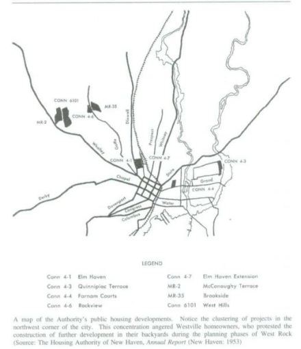
The defining characteristic of Rockview–and its neighboring developments, Brookside and Westville Manor–is their isolation. Adam Wolkoff wrote of the area’s remoteness in his excellent Connecticut History article (and Columbia University senior thesis) on the developments, “Creating a Suburban Ghetto: Public Housing at New Haven’s West Rock“:

Geography, combined with the institutional history of the site, meant that the Springside Farm had never been developed within the broader pattern of New Haven’s pre-war residential sprawl. In the shadow of the picturesque glacial moraine of West Rock Ridge State Park, and removed from shopping areas, employment centers, and mass transportation, it possessed a suburban quality, which one writer lamented in 1937, should have made it a choice location for first-class residences instead of a home for the indigent. Yet even after New Haven brought infrastructure and a critical mass of people to the site, it retained this secluded character, largely because the site was too inaccessible to attract investment. Geography, however, did not have to determine the fate of this community and to a great extent the development’s failure to become an integral part of greater New Haven was the product of political choices. Through a series of decisions, the city, in cooperation with the neighboring suburb of Hamden, walled off the project’s residents from the surrounding community. (pp. 70-71)

Rockview, Brookside, and Westville Manor were built to be “out of sight, out of mind”–to store New Haven’s needy in suburban greenery far from the grime and grit of the city’s inner neighborhood. Perhaps the outdoorsy benefits of the site were thought to outweigh its isolation; certainly, midcentury urban renewal in New Haven exhibited a fierce strain of the environmental determinism that infected renewal projects all across the country. More likely, the connection between land use and transportation needs was never considered. At that time of seemingly boundless political will, energy, and money, overcoming any obstacle–even sending buses miles out of their way to a remote development–certainly would have seemed possible.

Housing Authority of New Haven developments in 1953, via Wolkoff (see below). Brookside towards top left.

Housing Authority of New Haven developments in 1953, via Wolkoff. Brookside towards top left.

It is, sadly, not an unusual story; scattered-site public or designated-affordable housing, while seemingly  an attractive concept, is often later found to be sadly isolated both in terms of both social context and infrastructure needs. And so it was with the West Rock developments, which gradually slipped into decline–and then worse. But that story has been told many times over. I want to talk here about the impact that Rockview’s isolation has on CTTransit’s ability to serve it efficiently with transit, because, well, it’s not a pretty story.

Here’s a snip from CTTransit’s New Haven system map showing the Rockview/Brookside area and the adjoining Pine Rock neighborhood of Hamden:

Snip from CTTransit's New Haven system map, http://www.cttransit.com/uploads_RTDivisionSystem/NH_SysMap_2013.pdf

Snip from CTTransit’s New Haven system map, http://www.cttransit.com/uploads_RTDivisionSystem/NH_SysMap_2013.pdf

The West Rock area is served by the B1 variation of the B bus, the trunk route serving Whalley Avenue, one of New Haven’s main drags. The B1 leaves Whalley at Blake Street in Westville Village (map), and meanders over to terminate in Brookside after wandering past Westville Manor and the entrance to Rockview. It doesn’t connect to the G bus (technically, the G4 variation–maybe you’re getting a sense for why New Haven’s bus system is in need of a major revision) because, well, there’s no physical connection in the street grid. When Wolkoff writes that New Haven and Hamden combined to “wall off” the new developments, he means it literally; a fence was put in along the city-suburb border to forbid passage. The fence became such a symbol of contention and rancor that when it was finally taken down last year, even the New York Times paid attention. Neither bus comes with any particular frequency; the B1 operates with widely variable 10-25 minute headways at peak hours, and 30-minute headways off-peak, while the G4 condescends to circle through Pine Rock six times per day.

The problem, of course, is that it’s virtually impossible to serve such a remote development with efficient transit. Brookside and Rockview are being rebuilt to a fairly dense, New Urbanist-y standard, but they’re not big enough in and of themselves to be a major traffic generator on their own, and they’re not on the way to anything at all.  Reopening the connection from Wilmot Road to Woodin Road in Hamden, and the G4 bus, is a start, but a bus that operates that infrequently is just of very little utility to residents. The B1 provides decent service to the area–probably more than ridership really justifies–but it’s a prime example of some of the drawbacks of branching; every bus that turns to serve Brookside is a bus that doesn’t serve the far denser Whalley/Amity corridor, where buses often run full at rush hour. It’s not that Brookside and Rockview don’t deserve service. It’s just that the decision to site the developments there 65 years ago, and the much more recent decision to rebuild them in place, means that every bus serving them is a bus that doesn’t serve corridors with more demand. At the same time, it’s hard to justify serving the West Rock developments frequently enough to really build ridership, so they get service at somewhat random, not all that useful intervals.

In other words, Rockview’s bus problem is really an example of the coverage-ridership tradeoff. Succinctly put, this principle states that transit agencies and planners face a tradeoff in deciding how many of their resources to devote to “coverage” (trying to make sure as many geographic areas as possible have transit service, regardless of ridership potential), and how many to devote to building ridership in core areas that are likely to attract riders. A closely related phenomenon, labeled the bus complexity tradeoff by Streets.mn, is also at work here, as it is all across the New Haven bus system; a rider from downtown seeking to get to the Stop & Shop on Amity, say, could easily board a B1 rather than a B2 or B3 and wind up at Brookside, or vice versa. The coverage-ridership tradeoff means that serving Rockview and Brookside depresses ridership on core routes likely to attract more riders; the bus complexity tradeoff means that the complexity inherent in a system with as many branches–and twists and turns on those branches!–as New Haven’s is itself overwhelming and a turn-off to potential riders.

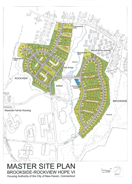
In the short term, improving Rockview’s access to transit really shouldn’t be that hard. Creating road and pedestrian access to Woodin Road and the G4 bus will help residents get to shopping, jobs, and amenities on Dixwell Avenue–but CTTransit will have to increase that bus’s frequency for it to be useful. In the meantime, residents seeking a ride down to the Green should not have to walk all the way down to Wilmot and Brookside. As can be seen in the Master Site Plan illustration above, plans at one point existed to link Brookside and Rockview with a road bridge that would give access to the bus stop at Brookside Ave. and Solomon Crossing. While site plans and road layouts have changed somewhat since then, in the short term a pedestrian bridge that would allow Rockview residents to reach that stop–a much shorter walk than the one to Wilmot and Brookside–seems eminently achievable. When I reached out to city transportation chief Doug Hausladen about that idea on Twitter, he responded enthusiastically:

https://twitter.com/doughausladen/status/573271626965495808

The long-term challenges are more severe. Rockview’s citizens have been disadvantaged, and the political and policy leaders serving them put in a difficult place, by decisions made over half a century ago. The failures of urban renewal and midcentury “rationalist” planning are myriad, but perhaps none is greater than the assumption that automobility had broken the connection between transportation and land use forever and that government would always be able to sustain rump transit service as a politically acceptable social service program. As we have learned, neither of those things was close to true. And as transit regains–through cultural shift or economic necessity–some of its past popularity, policymakers will be increasingly faced with the legacy of places like Rockview: physically isolated communities, crying out for service, but fundamentally hard to serve on a basis of rational efficiency. Rockview is a reminder of how long the planning mistakes of the past can linger, but it is also a warning for the future.

Reflections on Albany, Part 2–Challenges and Problems

A couple of weeks ago I wrote Part 1 of this series, reflecting on Albany’s assets and positives as a place to live and an American city. After considerable ribbing from friends and family and questions about whether I’m working for the Albany tourism bureau (I’m not, and in fact I’m now interning for the Tri-State Transportation Campaign, where you should check out my debut blog post), I’ve finally found the time here for Part 2, a breakdown of Albany’s challenges and problems. It’s certainly not all rosy out there–in fact, it is arguably more cloudy than rosy–so here we are.

Albany’s Problems and Challenges

1) Economy dominated by state work

This is the flip side of #5 (“Stable Economy”) on my list of positives. Despite the efforts of the Cuomo (and several previous) administration to create a high-tech hub in the region, the basis for the Capital District’s economy, and especially that of Albany, remains civil service. That provides a stable baseline for employment, but it’s not the most dynamic sector of the economy. Civil service is also incredibly hard to break into, reliant on a completely archaic system of pen-on-paper tests given at specific, obscure, and infrequent times. The cemented civil service structure brings needed stability for workers, but it also makes recruiting specific talent to government service–and to the Albany labor market generally–very, very difficult.

2) Provincial feel, perception, and self-image

The moniker “Smallbany,” used both earnestly and ironically, says a lot about Albany’s self-image. Like many such words it was initially an insult but has been reclaimed by some as a term of endearment; nevertheless, it says something real about the city. Government jobs mean a constant flow of people between Albany and New York City, so there is always a snooty New Yorker around to remind Albany natives about how backward their city is and to kvetch about being stuck here. Of course, Albany (and especially its Irish community) has long cultivated a provincial feeling of its own, captured well in William Kennedy’s novels.

3) Hard to find interest groups and people to identify with. Social life largely revolves around alcohol.

Maybe I’m just snooty relative to other students, but I don’t enjoy loud, crowded bars, and I’ve found it hard to find ways to socialize that don’t involve such things.

4) Hardened relationships between African-American community and governing class

Though I recently had to walk through a boisterous, crowded celebration of Black History Month (complete with an exhibit honoring ’60s militant group The Brothers) while leaving City Hall, Albany’s black community still largely occupies the place the O’Connell-Corning machine put it in, shut out of the city’s power structure. The black community in Albany, as in several other Northeastern cities, was not large until the postwar era, by which time the O’Connells’ iron grip had already descended. In political identity Albany is still very much an Irish-Catholic town, and for the black community that has meant decades of mostly being ignored and trod upon. Things are, I think, beginning to look up some, but for now Albany’s black neighborhoods remain vulnerable, decaying, and suffering from a legacy of exploitation.

5) Lagging on National Trends

The stereotype of second- and third- level metros is that they tend to be behind the times, and Albany is no exception, particularly in the field of planning and urbanism. Most people around here are still chasing the dream of free parking, huge lawns, and social isolation from their lessors, and, to be honest, this isn’t the kind of region that punishes that pursuit with horrendous traffic congestion or anything of the sort. Albany’s waterfront is marred by a horrendous, expensive, and unnecessary freeway, but the movement to get rid of it is barely in its nascent stages. Any movement towards better urbanism, parking policy, etc is vigorously opposed by the suburban (and near-suburban) lobby, which usually includes the state employee unions (see the next point).

6) Neglect by, and difficult relationship with, the state

Related to #1 and another flip side of #5 on the list of assets: the city’s domination by state work and state land has decided downsides. With up to 60% of the city’s land off of tax rolls–and much of that owned by the state–the city has been left with property taxes at unsustainable rates. Though the city recently got $5 million in assistance from the state’s Financial Restructuring Board, there is still need for more. The state has generally been an unsympathetic and unreliable partner, which is particularly stinging given that construction of the Empire State Plaza wiped out 98 acres of productive, dense neighborhoods and replaced it with freeways and (non-taxed) state buildings.

Institutionally owned properties in Albany, from the Albany 2030 comprehensive plan.

Institutionally owned properties in Albany, from the Albany 2030 comprehensive plan.

The state has often contended that its presence brings needed vitality to Albany and that its workers bring in more economic activity than could possibly be replicated in taxes. Of course, the vast majority of state workers drive into Albany in the morning and out at night, tearing up city-maintained roads as they go, and forming (with the help of their unions) a potent lobby for turning the city into one giant parking lot. And though the Empire State Plaza might have kept tens of thousands of state jobs in downtown Albany, it is a nearly entirely self-contained environment with its own food court, post office(s) and, soon, supermarket, all of which add up to limit its positive spillover effects. For Albany to have a bright future, the sclerotic New York State political establishment will have to stop treating it like a dump and start realizing that a livable state capital city is necessary for bringing in a talented state workforce. Of course, they’ve got little incentive to realize either of those things right now.

7) Competes both with suburbs and with other Capital District cities for immigrants and talent

This is the flip side of #8 in my previous post. True, the three major Capital District cities provide a unique mix of assets and play off of each other nicely. But Albany, though the most prominent of the three, also has to compete not only with the suburbs but with the other two cities for the immigrants who are so crucial to urban vitality and for the picky young talent that will form the basis of the next urban generation. Schenectady, though very much a suffering city economically, has attracted a significant immigrant population. Troy has been proclaimed the Next Brooklyn so many times that it’s become an eyeroll-provoking cliche.

8) Legacy of urban renewal

The tragic truth is that Albany came thisclose to avoiding massive urban renewal projects altogether. The O’Connell machine, suspicious of outsiders and in particular those squeaky-clean feds with all of the strings attached to their money, avoided taking federal dollars for urban renewal in the postwar period. That situation (which extended to housing projects as well and had negative ramifications for Albany’s black community) meant that Albany did not see large-scale slum clearance until the 1960s, as the momentum of urban renewal was starting to slow in other Northeastern cities.  I-90 missed the city to the north and the New York State Thruway to the south.

When “renewal” did come, it was provoked not by local officials but by Governor Nelson Rockefeller, whose insistent pushing–and backroom deals with Mayor Erastus Corning–eventually did wipe out the proverbial 98 acres of central Albany. The slider images from the University of Oklahoma’s Quality Communities project demonstrate the devastation nicely. I can’t embed their Albany image here, but click on the link. And the Plaza opened the floodgates for highway construction as well.

via All Over Albany, the Mid-Crosstown Arterial would have run two doors down from my apartment.

via All Over Albany, the Mid-Crosstown Arterial would have run two doors down from my apartment.

Though Albany avoided being dissected by urban freeways and having an interchange embedded under Washington Park, the (entirely unnecessary) South Mall Arterial spur leading into the Plaza and I-787 along the waterfront did more damage than arguably the Plaza had done all on its own. Although, to be fair, Albany has always been cut off from its waterfront by industry, 787 sealed its alienation from nature, and cut the approaches to downtown’s Union Station, forcing intercity trains across the Hudson to Rensselaer (see #10 below).

9) Tension between machine legacy and progressive good-governance streak 

Like all capital cities, Albany has its fare share of liberal, middle-class, managerial households; indeed, they formed the nucleus of some of the most important opposition to the longtime machine. And yet, it is only with the 2013 election of Mayor Kathy Sheehan that this technocratic class can really be said to have gained control of Albany city government. The last round of elections, in November 2014, led to several open conflicts between the progressive, reform wing of the Democratic part and the conservative wing that can be fairly said to be the legacy of the old machine.

In many ways, the legacy of the O’Connell-Corning machine still thrives. Snow removal is still ineffectively contracted out; our streets get swept every week despite a budget hole; and there is remarkably little tradition of political activism in the city. For the most part, “apathy” appears to be the predominant mode of relation to local politics in Albany. Where the old machine succeeded in suppressing voter interest for decades, the challenge of Albany’s political culture in the decades ahead will be to create an engaged, caring, educated citizenry.

10) Disjointed, incomplete, and expensive intercity transportation

A while ago I wrote about the sad situation of Albany’s gorgeous-but-inaccessible Amtrak station. The removal of the approach tracks to downtown’s beautiful Union Station meant the transfer of passenger operations across the river to Rensselaer, probably never to be restored.

Union Station, 1948  Albany NY 1940s

Union Station in happier times. Via AlbanyGroup Archive on Flickr. 

Albany’s Greyhound station, situated in a sea of parking lots in the shadow of the South Mall Arterial, is an absolute dump, and poorly integrated with other transportation options. Megabus stops at the Amtrak station. Flying out of Albany’s airport is extremely expensive and inconvenient, with limited schedules and virtually nonexistent transit connections to downtown (there’s a local bus a few times per day). Though CDTA has been on-the-ball about advocating for a new, integrated downtown bus terminal, that may or may not happen, and still wouldn’t draw in Amtrak. The disconnection of Union Station means commuter rail, a topic that gets broached every so often in the region, would likely be entirely unsuccessful since there’s no conceivable downtown Albany terminal. For a capital city, it can be awfully difficult to get to Albany.

11) Struggling schools, or perception thereof

Schools were another area neglected under the O’Connell machine. Albany’s Irish Catholics–though for most of its life the machine was less ethnically identified than others, it still had a distinct Irish tinge–sent their kids to parochial school, and the public schools were left to rot. I’m not sure the system has ever really recovered. Albany has essentially one large public high school to which most students, regardless of background, go. That could work well, but from what I’ve heard from kids who attend, it basically leads to extreme class and academic segregation. The other schools have typical urban school struggles. This is hardly a problem unique to Albany.

12) Old city problems: high property taxes, old infrastructure, regulations on small business

Albany’s an old city, and its history is one of the best things about it. But that also means that a lot of the city’s infrastructure is crumbling, and too often the city can’t afford to repair it. The roads are heavily potholed. Streetlights and traffic lights don’t work and go weeks without repair. Water main breaks are common. All of this is (not) paid for with high property taxes on the relatively small proportion of city land that actually gets taxed. It can also be a drag to do business in Albany, even (especially?) for small businesses.  Mayor Sheehan, a former city treasurer, is selling herself as a budget whiz, and seems to be making progress so far, but it seems that nothing short of a comprehensive bill of reparations from the state for the Empire State Plaza (which cost $2.2 billion…in 1970 dollars. That sounds like a nice amount, doesn’t it?) will allow the city to stop playing catch-up and finally get ahead of its challenges.

13) Perception of Albany as a place to work and little else

This is, perhaps, the biggest challenge Albany has to overcome. Though it is the dominant city in the region, it isn’t that much bigger than next-door, sprawling Colonie (~97,000 to ~82,000), and struggles to be taken seriously by the suburban hordes. Certainly the state’s actions in creating the car-oriented Plaza and giving most state employees free parking have much to do with the suburban perception of Albany as a drive-in, drive-out city, but Albany has also struggled to take itself seriously as an urban place. Most suburbanites and state workers react with horror to the idea of raising their kids in the city, if it’s even on their radar at all. I suspect that will change with evolving generational preferences. But it might take a while; Albany, after all, isn’t the most trendy place.