Though it’s been variable given how much I’ve moved around, my most frequent Thanksgiving destination since my family moved to New Haven in 1994 has been my aunt Karen‘s in Northampton, MA. Over 20 years of visiting, I’ve grown to really like Northampton and the broader Pioneer Valley. While it can be more than a little precious, and even insufferable at times, the region has a nice variety of assets and more than a few interesting challenges to tackle.
On this particular trip, I actually had a professional assignment: for a transit planning class, I’m doing part of a group review of the Pioneer Valley Transit Authority system. From a transportation planning perspective, the Pioneer Valley is an interesting challenge in that, with the exception of the decent-sized Springfield metro at the southern end, it has a number of smallish nodes of density and activity with relatively little in between.
Some of my part of the project is examining the possibilities for rail transit in the area, something I wrote about here very early on–as well as an active political desire among Valley leaders. Though I think I know the area fairly well for someone who doesn’t live there, I hadn’t seen many of the areas I’m proposing for stations from ground level, and I hadn’t seen the new stations that opened over the last year to serve the Vermonter in Holyoke, Northampton, and Greenfield at all. So I took the opportunity of Black Friday and the Sunday following–and my very generous partner–and scouted the Connecticut River Line, as it is known, in full from Greenfield to Springfield. Here are some notes from those trips.
Greenfield
Not technically part of the PVTA service area (Franklin County has its own transit agency, the Franklin Regional Transit Agency), Greenfield may in fact have the best multimodal center of any town in the Valley, at least until the revamped Springfield Union Station opens. Just a block from Main Street, the John W. Olver Transit Center integrates local and intercity buses, and now a (temporary) platform for Amtrak’s Vermonter and whatever rail service may follow.

The temporary platform and the Olver TC (on the right)

Better view of the temporary platform. It’s a nice model, I don’t really know why Greenfield would need much more. Note the MBTA-style station sign; is the state prepping for commuter service?

Looking north along the Conn River Line from the temporary platform. The former Boston & Maine line to the Hoosac Tunnel curves off to the left. The red thing on the left is a canopy covering a staircase up to Energy Park, the former location of Greenfield’s old junction station (there’s a caboose on display back there if you look carefully).

A better view of Olver TC. I find the building itself kind of ugly, but it seems to work well and has nice amenities on the inside. In fact, it stands somewhat in contrast with FRTA’s aging bus fleet.
East Deerfield
No, it’s not a potential passenger station, but I couldn’t resist the temptation to visit Pan Am’s East Deerfield yard, just off the Conn River line southeast of Greenfield.

Pan Am seems to have borrowed a Vermont Railway system loco to help out.

There’s an old MBTA coach stashed back there for some reason (note also the snowplow just to its left). I might be tempted to go start running a passenger service on the line with just that one coach and a locomotive…

Just as we were getting ready to leave (there really wasn’t much going on), one of the numerous railfans gathered at the yard on this glorious 60-degree Black Friday mentioned there was a westbound autorack train about to come through. This is my favorite of the resulting pictures.
Old Deerfield
Just a few miles south of Greenfield, this is probably a marginal spot for a new station, but it did historically have a depot, and between Deerfield Academy, the Eaglebrook School, and tourist traffic to Historic Deerfield, there might be enough to sustain a stop. What’s there now, though, is down a rough, potholed 1.5 lane road with a “closed during the winter season” sign…and there’s not much to see.

Trusty steed “Fred” (yes, I have warm feelings for my car, though I’d get rid of it in a second if we lived someplace bigger) on the clearing where I think the old Deerfield station was.

Looking north. A passing siding begins here.
South Deerfield
The only town of any size between Northampton and Greenfield, and it’s not really that big. But it’s walkable and has a few decent-sized employers (the station site is only a few blocks from the massive Yankee Candle factory/outlet, which was crazy full on Black Friday).

That’s a hella nice grade crossing they put in when the Conn River Line was reconstructed.

Looking south from Elm Street in South Deerfield, the ROW actually widens to three tracks to serve a couple of customers.

Looking north from Elm Street, there’s a nice space for a station and park and ride on the west side of the tracks.

I don’t know if this is the original station or a replica, but it’s renovated nicely for a siding company. (pun on the piece of track out in front semi-intended)

Gotta have a station sign in classic font! This appears new, so I wonder if it was done recently.
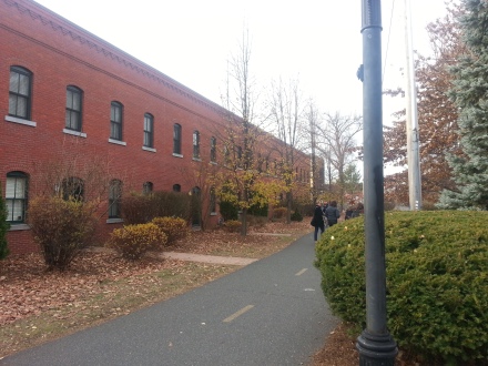
Northampton
I considered throwing in a stop in West Hatfield, but I decided it was too marginal to be worth it (OK, I missed the turn and was hungry, but I had already pretty much made up my mind!) I also think a stop at Damon Road in Northampton is a good idea, but there’s no safe way to park and approach it on foot, so we grabbed lunch and skipped right to Northampton Union Station.

The temporary platform at Northampton is a virtual twin of Greenfield’s, though on the other side of the tracks. The folks standing on it in the picture are waiting for the southbound Vermonter, which wouldn’t show up until hours later after it hit a couple of people sitting on the tracks north of White River Junction.

The new platform is next to, though not integrated with, the now privately-owned former Union Station. They share a good deal of parking, which was mostly empty despite the mobs descending on downtown Northampton for Black Friday lunch. #blackfridayparking indeed.

Main Street, Northampton, looking west from the Canal Trail bridge over it.
Bicycle-oriented development: apartments just north of Union Station have doors opening directly onto the Canal Trail.

The southern face of the Union Station building was once the platform for the New Haven & Northampton division of the New Haven railroad, much of which is now a bike path.
Holyoke
Arguably the most depressed city in the Pioneer Valley, Holyoke is the only one to currently boast an (almost) full-scale train station. It’s also the newest, kicking off in August at a cost of $4.3 million.

The station boasts a 400-foot high-level platform and various amenities one would expect at a station with more than one train per day in each direction, including a bike rack and signs for a bus drop-off.

MBTA-style signage, like Greenfield and Northampton.

Looking south along the platform.

Looking north from the platform, Holyoke’s 1880 H. H. Richardson-designed station is visible.

The Holyoke site has serious TOD potential, with architecturally impressive but vacant buildings right next to and across from the parking lot, and plenty of adjacent vacant land.
All in all, fairly impressive for $4.3 million–and clearly designed for more than just the occasional Vermonter.
Chicopee
Before talking about the potential for a train station, let me just say: what’s up with the four-lane, super-wide one-way streets, Chicopee? Totally unnecessary for a town of this size.
The site I’ve flagged for a new Chicopee station isn’t ideal–it’s separated from the town by I-391, for example–but it seems to be the best option for a town that could use the service.

Looking south. There are actually four trackways on the bridge; there was once a small yard here.

Looking north.
Wason Avenue, Springfield
The site is at least as interesting for its historical connections as for its potential today. Wason Ave. was named after the Wason Manufacturing Company, a late-19th and early-20th century builder of railcars and especially trolleys. Wason’s plant once occupied the area around the rail crossing here, sending out trolleys to customers far and wide (though a large proportion of its business seems to have been concentrated right in Massachusetts).

The Wason Manufacturing plant, courtesy of the Library of Congress
Wason lasted, as a subsidiary of the larger Brill company, until 1932. Today few of the original plant buildings remain, which is actually fairly unusual for New England. The area of the plant is only blocks from Baystate Medical Center, though, and the hospital and affiliate buildings have sprawled into it, such that it has become a major center of medical employment. The built environment is pretty awful, with huge parking lots and high-speed traffic.

Looking northwest; I believe the arch-windowed building in the background is an original Wason plant building.

Looking south.

Just south and west of the Wason Avenue crossing (the tracks run just out of the picture to the left). Parking lot and weep.
Springfield Union Station
Our final stop was Springfield Union Station, the subject of an ongoing $80+ million renovation project that will return the station to its previous glories in preparation for the implementation of commuter service from New Haven and Hartford sometime in the next two years, and hopefully service to Boston sometime after that. It’s an impressive project that will integrate a terminal for local PVTA buses and hopefully intercity buses as well. The future looks pretty glorious:

Let’s play “spot the technical improbability” with this image.
But the present is rather less glamorous. There wasn’t much going on on a quiet November Sunday, but there’s still clearly a lot of work to be done and it takes some imagination to see that rendering coming together.


Though there’s a long way to go, it’s still a very hopeful project for downtown Springfield–and hope is something that city needs. And on that sentiment, this tour is over.

Network effects will really help here. Once NHHS is up and running and the Inland Regionals come back and provide a link to Boston, there’s more for the Pioneer Valley service to connect to and thus more justification for running it. Maybe one day Springfield will regain its status as a crossroads of New England.
Did you go to LocalBurger for lunch in Noho? That’s where I’d go.